Related Research Articles

Margaret River is a town in the South West of Western Australia, located in the valley of the eponymous Margaret River, 277 kilometres (172 mi) south of Perth, the state capital. Its Local Government Area is the Shire of Augusta-Margaret River.
Leeuwin-Naturaliste National Park is a national park in the South West region of Western Australia, 267 km (166 mi) south of Perth. It is named after the two capes either end of the park, Cape Leeuwin and Cape Naturaliste. It is located in the Augusta-Margaret River and Busselton council areas, and is claimed to have the highest visiting numbers of any national park in Western Australia. The park received 2.33 million visitors through 2008–2009.

Antoine Raymond Joseph de Bruni, chevalier d'Entrecasteaux was a French Navy officer, explorer and colonial administrator who served as the governor of Isle de France from 1787 to 1789. He is best known for his exploration of the Australian coast in 1792 while searching for Jean-François de Galaup, comte de Lapérouse.

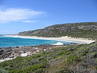
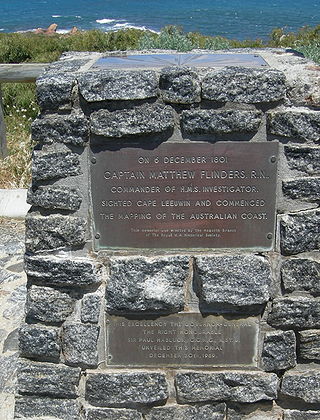
Cape Leeuwin is the most south-westerly mainland point of the Australian continent, in the state of Western Australia.

Augusta is a town on the south-west coast of Western Australia, where the Blackwood River flows into Flinders Bay. It is the nearest town to Cape Leeuwin, on the furthest southwest corner of the Australian continent. In the 2001 census it had a population of 1,091; by 2016 the population of the town was 1,109.
Flinders Bay is a bay in western Australia, immediately south of the townsite of Augusta, and close to the mouth of the Blackwood River.

Hamelin Bay is a bay and a locality on the southwest coast of Western Australia between Cape Leeuwin and Cape Naturaliste. It is named after French explorer Jacques Félix Emmanuel Hamelin, who sailed through the area in about 1801. It is south of Cape Freycinet.
St Alouarn Islands are a group of islands and rocks south-east of Cape Leeuwin in Western Australia, approximately 11 km south of Augusta in Flinders Bay.

Geographe Bay is in the south-west of Western Australia, around 220 kilometres (140 mi) southwest of Perth.
Rear-Admiral Jacques Félix Emmanuel Hamelin was a French Navy officer and explorer. He fought in numerous naval engagements during the French Revolutionary and Napoleonic Wars and conducted several exploratory voyages in the Indian Ocean and Southern Ocean.

Cape Naturaliste is a headland in the south western region of Western Australia at the western edge of the Geographe Bay. It is the northernmost point of the Leeuwin-Naturaliste Ridge which was named after the cape. Also the Leeuwin-Naturaliste National Park, Cape Naturaliste Lighthouse and the Cape to Cape hiking track were named after this location.

Cape Freycinet is a point on the coast between Cape Leeuwin and Cape Naturaliste in the south west of Western Australia.
The Baudin expedition of 1800 to 1803 was a French expedition to map the coast of New Holland. Nicolas Baudin was selected as leader in October 1800. The expedition started with two ships, Géographe, captained by Baudin, and Naturaliste captained by Jacques Hamelin, and was accompanied by nine zoologists and botanists, including Jean-Baptiste Leschenault de la Tour, François Péron and Charles-Alexandre Lesueur as well as the geographer Pierre Faure.

Leeuwin, was a Dutch galleon that discovered and mapped some of the southwest corner of Australia in March 1622. It was captained by Jan Fransz and was the seventh European ship to sight the continent.

Many surfing locations are found along the coast of the Capes Region in Western Australia. The Capes Region, also known as Cape to Cape, is situated between Cape Naturaliste and Cape Leeuwin, within a larger region known as the South West. Despite their wide geographic range, most surf breaks in the Capes Region tend to be associated with Margaret River, situated roughly central to the stretch of coast along which they are located.
The Ngari Capes Marine Park is a marine protected area on the lower south west coast of Western Australia, located approximately 250 kilometres (160 mi) south of Perth. The 123,790-hectare (305,900-acre) marine park was gazetted on 12 June 2012 and the park's western and southern boundaries are the limit of coastal waters of Western Australia, abutting the South-west Corner Marine Park located within the Australian Commonwealth exclusive economic zone.

Caves Road is a 111-kilometre-long (69 mi) scenic route in the South West region of Western Australia. It connects western Busselton with Augusta, running along or to the west of the Leeuwin-Naturaliste ridge, and is an alternative route to Bussell Highway. Caves Road is also a major component of the route from Cape Naturaliste to Cape Leeuwin, in what is known as the state's Capes Region.
Tourist Drives in Western Australia are routes through areas of scenic or historic significance, designated by route markers with white numbers on a brown shield. Tourist Drives were introduced into Western Australia while Eric Charlton was the state government Minister for Transport in the 1990s. The 28 numbered routes collectively traverse more than 2,000 kilometres (1,200 mi) across the state. In addition to the Tourist Drives, there are unnumbered routes such as the Golden Pipeline Heritage Trail, and local governments may designate and maintain local scenic drives, generally unnamed and unnumbered.
Cape Clairault is located south of Yallingup in the coastal region between Cape Naturaliste and Cape Leeuwin.

Hamelin Island lies north of Cape Hamelin, just out to sea from the former Hamelin Bay Jetty, on Hamelin Bay, on the south west coast of Western Australia, about 7 kilometres (4.3 mi) north of Cape Leeuwin.
References
- ↑ Marchant, Leslie R. (Leslie Ronald); Marchant, Francis C. R (2004), Heritage trail guide to French Napoleonic period names along the South West Coast of Australia from Point Peron to Cape Leeuwin, R.I.C. Publications, ISBN 978-1-74126-094-6
- ↑ Fornasiero, F. J; Monteath, Peter; West-Sooby, John; ebrary, Inc; EBSCOhost (2011), Encountering Terra Australis the Australian voyages of Nicolas Baudin and Matthew Flinders ([Revised ed.] ed.), Wakefield Press, retrieved 27 December 2013
- ↑ "WESTERN AUSTRALIA". South Australian Register . Adelaide: National Library of Australia. 9 July 1883. p. 5. Retrieved 27 December 2013.
- ↑ "Scientists Will Study Crayfish Migration". The West Australian . Perth: National Library of Australia. 16 December 1952. p. 7. Retrieved 27 December 2013.