Related Research Articles

Muan County (Muan-gun) is a county in South Jeolla Province (Jeollanam-do), South Korea. In 2005, Muan County became the capital of Jeollanam-do following the transfer of the provincial office from its previous location, Gwangju to the village of Namak in Muan. Muan International Airport was opened here, and will eventually replace the airports in Gwangju and Mokpo.

Buan County (Buan-gun) is a county in North Jeolla Province, South Korea. It is bounded by the city of Jeongeup on the east, the county of Gochang on the south, the city of Gimje on the north, and Yellow Sea on the west. Buan is divided into 1 eup, 12 myeon, and 510 ri. Buan had a 2001 estimated population of 74,716 people and a 2018 population of 54,441 people with an area of 493.35km2. Famous people from Buan include Joseon Dynasty kisaeng and poet, Yi Mae-chang. Like many rural areas in southern Korea, it has seen shrinking population with many younger people moving north to larger cities such as Seoul. This county should not be confused with Muan, the new capital of South Jeolla Province.

Wanju County (Wanju-gun) is a county in North Jeolla Province, South Korea. This county should not be confused with Wonju, in Gangwon-do. It almost entirely surrounds Jeonju.
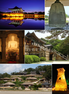
Gyeongju, historically known as Seorabeol, is a coastal city in the far southeastern corner of North Gyeongsang Province in South Korea. It is the second largest city by area in the province after Andong, covering 1,324 km2 (511 sq mi) with a population of 264,091 people Gyeongju is 370 km (230 mi) southeast of Seoul, and 55 km (34 mi) east of Daegu. The city borders Cheongdo and Yeongcheon to the west, Ulsan to the south and Pohang to the north, while to the east lies the coast of the [[East Sea (Korea)|East Sea ]. Numerous low mountains—outliers of the Taebaek range—are scattered around the city.

South Korea is made up of 17 first-tier administrative divisions: 6 metropolitan cities, 1 special city, 1 special autonomous city, and 9 provinces, including one special autonomous province. These are further subdivided into a variety of smaller entities, including cities, counties, districts, towns, townships, neighborhoods and villages.

Dongducheon is a city in Gyeonggi Province, South Korea.

Icheon is a city in Gyeonggi Province, South Korea. It should not be confused with the much larger Incheon Metropolitan City. Neighboring districts include Yeoju City, Gwangju City, Yongin City, and Anseong City within Gyeonggi Province, as well as Eumseong County in North Chungcheong Province. Together with Yeoju, Icheon is known as a center of South Korean ceramic manufacturing and is a UNESCO City of Crafts and Folk Art. Other famous local products include peaches and rice. Local institutions of higher learning include Korea Tourism College and Chungkang College of Cultural Industries.

Uiwang is a city in Gyeonggi Province, South Korea. It is one of many satellite cities that ring Seoul, making up the Seoul National Capital Area. Its largest immediate urban neighbor is Anyang. The low peaks of the Gwangju Mountains shape the local landscape.

Seosan is a city in South Chungcheong Province, South Korea, with a population of roughly 175,000 according to the 2017 census. Located at the northwestern end of South Chungcheong Province, it is bounded by Dangjin City, Naepo New Town, Yesan-gun and Hongseong-gun on the east and by Taean-gun and the Yellow Sea on the west, and 125 km (78 mi) south of Seoul, 159 km (99 mi) northwest of Daejeon and 34 km (21 mi) northwest of Naepo New Town. Seosan is the hub of transportation of west coast where Seohaean Expressway, Daejeon-Dangjin Expressway, National Highways No. 29, 32, 38 and 45 intersect meet, this city has great traffic conditions towards the metropolitan area and major cities.

Gimcheon is a city in North Gyeongsang Province, South Korea. It is situated on the major land transportation routes between Seoul and Busan, namely the Gyeongbu Expressway and Gyeongbu Line railway.

Ulleung County (Ulleung-gun) is a county in North Gyeongsang Province, South Korea. It consists mainly of the island of Ulleungdo, but is held to cover a total of 44 islands, including the Liancourt Rocks (Dokdo), which is in effective governance by South Korea. All of these islands lie within the Sea of Japan.

Miryang, often spelled Milyang, is a city in Gyeongsangnam-do Province, South Korea. Neighboring cities include Changnyeong to the west, Cheongdo to the north, Ulsan to the east, and Yangsan, Gimhae, and Changwon to the south. The city bird is the Korean magpie, the city tree is the pine, and the city flower is the royal azalea.

Haman County (Haman-gun) is a county in South Gyeongsang Province, South Korea. The local government is seated in Gaya-eup. The county magistrate is Seok Gyu Jin.
Hamchang is an eup in Sangju City, North Gyeongsang province, South Korea. It comprises 30 distinct ri, and has a population of 8,427. There are two elementary schools, a middle school and a high school. Hamchang was once the capital of a small kingdom, Goryeong Gaya. Although its role today is far less central, it remains an important local town, served by intercity buses as well as the Gyeongbuk Line railroad.

Eonyang is an eup, or large village, in Ulju-gun, a largely rural district of Ulsan, South Korea. It is near the Seoknam Nun's Temple. It has a traditional market every five days.
Pungsan-eup is a town in Andong in Southeast section of South Korea. It stands on the Nakdong River to the west of Andong's city center. It lies on the standard tourist course between downtown Andong and the Hahoe Maeul folk village in Pungcheon-myeon. Local landmarks include the Yucheon Museum of Hanji Art.

Gijang County is a gun, or county, located between Haeundae-gu and Ulsan in northern Busan, South Korea.

Samnangjin or Samnangjin-eup, is an eup, or town, in Miryang City, Gyeongsangnam-do, South Korea. It is composed of thirteen ri. Samnangjin lies in the southeastern corner of Miryang, bordering Wondong-myeon in Yangsan City.

Angang-eup is an eup or a town and is the second-largest subdivision of Gyeongju City. Its 139 square kilometers are home to about 33,300 people, and is served by six elementary schools and two joint middle-high schools. Situated next to Gangdong-myeon in the city's northern tip, it is a significant town in its own right. Angang Station is a regular stop on the Donghae Nambu Line. The town center lies on the Hyeongsan River, near where it meets the small Chilpyeongcheon stream. Important local products include rice, apples, and grapes.
An eup or ŭp (Korean: 읍) is an administrative unit in both North Korea and South Korea similar to the unit of town.
References
- ↑ "읍면동별 세대 및 인구". Archived from the original on 2007-09-28. Retrieved 2006-09-22.
- ↑ "특산물". Archived from the original on 2004-08-10. Retrieved 2006-09-23.