
The Metropolitan Borough of Rochdale is a metropolitan borough of Greater Manchester in England. Its largest town is Rochdale and the wider borough covers other outlying towns and villages, including Heywood, Littleborough, Middleton & Milnrow. It is the ninth-largest district by population in Greater Manchester with a population of 226,992 in 2022.
Rochdale is a town in Greater Manchester, England, and the administrative centre of the Metropolitan Borough of Rochdale. In the 2021 Census, the town had a population of 111,261, compared to 223,773 for the wider borough. Rochdale is in the foothills of the South Pennines and lies in the dale (valley) of the River Roch, 5 miles (8 km) north-west of Oldham and 10 miles (16 km) north-east of Manchester.

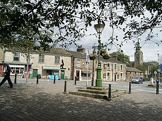
Milnrow is a town within the Metropolitan Borough of Rochdale, in Greater Manchester, England. It lies on the River Beal at the foothills of the South Pennines, and forms a continuous urban area with Rochdale. It is 2 miles (3.2 km) east of Rochdale town centre, 10 miles (16.1 km) north-northeast of Manchester, and spans from Windy Hill in the east to the Rochdale Canal in the west. Milnrow is adjacent to junction 21 of the M62 motorway, and includes the village of Newhey, and hamlets at Tunshill and Ogden.

The River Roch is a river in Greater Manchester in North West England, a tributary of the River Irwell.
Littleborough is a town in the Metropolitan Borough of Rochdale, Greater Manchester, England, in the upper Roch Valley by the foothills of the South Pennines, 3 miles (4.8 km) northeast of Rochdale and 13 miles (20.9 km) northeast of Manchester; Milnrow and the M62 motorway are to the south, and the rural uplands of Blackstone Edge to the east. According to the 2001 census, Littleborough, and its suburbs of Calderbrook, Shore and Smithy Bridge, had a population of 13,807.
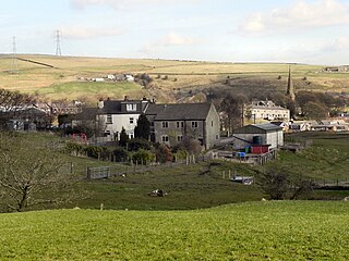
Wardle is a village near Littleborough within the Metropolitan Borough of Rochdale, in Greater Manchester, England. It lies amongst the foothills of the South Pennines, 1.8 miles (2.9 km) east-southeast of Whitworth, 2.5 miles (4 km) north-northwest of Rochdale and 12 miles (19 km) north-northeast of the city of Manchester.

Clegg Hall is a Grade II* listed 17th-century hall in Littleborough, Greater Manchester, England. It is situated just outside Smithy Bridge.

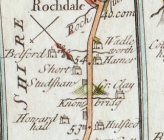
Butterworth was a township occupying the southeastern part of the parish of Rochdale, in the hundred of Salford, Lancashire, England. It was also a civil parish. It encompassed 12.1 square miles (31 km2) of land in the South Pennines which spanned the settlements of Belfield, Bleaked-gate-cum-Roughbank, Butterworth Hall, Clegg, Haughs, Hollingworth, Kitcliffe, Lowhouse, Milnrow, Newhey, Ogden, Rakewood, Smithy Bridge, Tunshill and Wildhouse. It extended to the borders of Crompton to the south, and to the highest points of Bleakedgate Moor and Clegg Moor, up to the ridge of Blackstone Edge, to the east, where its boundary was the old county boundary between Lancashire and Yorkshire. In 1891 the parish had a population of 9438.

There are 236 Grade II* listed buildings in Greater Manchester, England. In the United Kingdom, the term listed building refers to a building or other structure officially designated as being of special architectural, historical or cultural significance; Grade II* structures are those considered to be "particularly significant buildings of more than local interest". In England, the authority for listing under the Planning Act 1990 rests with Historic England, a non-departmental public body sponsored by the Department for Culture, Media and Sport.
Mellor Hall is a country house in Mellor, Greater Manchester, England, 0.4 miles (0.64 km) north of the Devonshire Arms off Longhurst Lane.

New Hall is a 17th-century house in Woodford, in the Metropolitan Borough of Stockport, Greater Manchester, England. Above the door, there is a Tudor-arched lintel with the date '1630' along with the initials 'WDED' and the family shield. Another branch of the Davenport family owned Bramall Hall in nearby Bramhall. The house, along with an adjoining cottage, is a Grade II* listed building.

Rochdale Borough Council is the local authority of the Metropolitan Borough of Rochdale in Greater Manchester, England. It is a metropolitan borough council and provides the majority of local government services in the borough. The council has been a member of the Greater Manchester Combined Authority since 2011.
Joseph Stretch Crowther was an English architect who practised in Manchester. His buildings are mainly located in Manchester, Cheshire and Cumbria.
Littleborough is a town in the Metropolitan Borough of Rochdale, Greater Manchester, England, and it is unparished. The town, its suburbs of Calderbrook and Smithy Bridge, and the surrounding countryside contain 79 listed buildings that are recorded in the National Heritage List for England. Of these, five are listed at Grade II*, the middle grade, and the others are at Grade II, the lowest grade. The area is largely rural, and most of the listed buildings are houses and associated structures, farmhouses, and farm buildings. Following the Industrial Revolution textile mills were built, some of which remain and are listed. The Rochdale Canal passes through the area and bridges and locks associated with it are listed. Also passing through the area was the Manchester and Leeds Railway, and structures associated with it are listed. The other listed buildings include churches, public houses, a former toll house, a bandstand, a drinking fountain, and two war memorials.
Milnrow is a town in the Metropolitan Borough of Rochdale, Greater Manchester, England, and it is unparished. The town, with its suburb of Newhey and the surrounding countryside, contains 49 listed buildings that are recorded in the National Heritage List for England. Of these, three are listed at Grade II*, the middle grade, and the others are at Grade II, the lowest grade. Until the Industrial Revolution the area was rural and agricultural and most of the earlier listed buildings are houses and associated structures, farmhouses and farm buildings. When the textile industry arrived, it was initially carried out in domestic premises, and many of the listed buildings of this time are houses, often with three storeys and rows of multi-light mullioned weavers' workshop windows on the upper floors. Later came mills, one of which has survived and is listed. The other listed buildings include a public house, a bridge, churches and items in churchyards, a library and a war memorial.
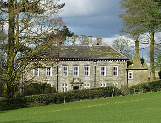
Great Howorth House is a Grade II listed privately owned historic house in Wardle, Rochdale, Greater Manchester.
Long Clough is a Grade II listed privately owned historic house in Littleborough, Greater Manchester.
Brandlesholme Old Hall is a Grade II* listed privately owned historic house in Brandlesholme, Bury, Greater Manchester, England.
St Chad's Church is the Church of England parish church of Rochdale in Greater Manchester, England. It forms part of the Diocese of Manchester. It is an active place of worship and community hub for the town and outlying suburbs around the town. It is a grade II* listed building and sits at a high elevation above both Rochdale Town Hall and the town centre.
