Champ is an unincorporated community in Audrain County, in the U.S. state of Missouri.
Only is an unincorporated community in southwest Camden County, in the U.S. state of Missouri. The community was located on Missouri Route O, approximately 3.5 miles south-southeast of Macks Creek and about 1.5 miles north of the Camden-Dallas county line. The location is on the Niangua Hills, three miles west of the Niangua River.
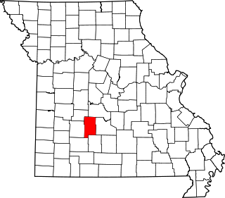
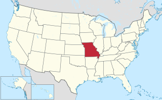
Boyd is an unincorporated community in Dallas County, in the U.S. state of Missouri.
Charity is an unincorporated community in Dallas County, in the U.S. state of Missouri.
Cloverdale is an unincorporated community in Dallas County, in the U.S. state of Missouri.
Corkery is an extinct town in Dallas and Laclede counties, in the U.S. state of Missouri. The GNIS classifies it as a populated place. The community area is located on a ridge surrounded on three sides by an entrenched meander of the Niangua River which is about 300 feet below the ridgetop. The location is only accessible by road from Laclede County.
Elixer is an unincorporated community in Dallas County, in the U.S. state of Missouri.
Hico is an extinct town in Dallas County, in the U.S. state of Missouri. The community was located adjacent to the Niangua River, approximately two miles northeast of Spring Grove and six miles southeast of Buffalo. The Hico Bridge over the Niangua on County Road JJ-203 is approximately 1000 feet west of the Hico location.
Leadmine is an unincorporated community in northern Dallas County, in the U.S. state of Missouri. The community is located about 3.5 miles east of Tunas on Missouri Route E. The Lead Mines Conservation Area lies one-half mile to the east. It is approximately 50 miles north-northeast of Springfield.
March is an unincorporated community in southeast Dallas County, in the U.S. state of Missouri. The community is located at the intersection of Missouri routes 38 and F.
Mathis is an unincorporated community in Dallas County, in the U.S. state of Missouri.
Olive is an unincorporated community in southeastern Dallas County, in the U.S. state of Missouri.
Plad is an unincorporated community in Dallas County, in the U.S. state of Missouri.
Reynolds is an unincorporated community in Dallas County, in the U.S. state of Missouri.
Shady Grove is an unincorporated community in southeast Dallas County, in the U.S. state of Missouri. The community was located on Route M, approximately five miles west of Conway. The Shady Grove School was just south of Route M, near the headwaters of Goose Creek.
Thorpe is an unincorporated community in Dallas County, in the U.S. state of Missouri. The community lies just north of the Dallas-Webster county line, with Missouri Route W and the Niangua River passing about one mile to the east. The community lies approximately midway between Buffalo, eleven miles to the northwest and Marshfield, eleven miles to the southeast.
Tilden is an unincorporated community in Dallas County, in the U.S. state of Missouri.
Agnes is an unincorporated community in southern Laclede County, Missouri, United States. Agnes is located on State Route O on the west side of Cobb Creek and approximately three miles north of the Laclede-Wright County line. Agnes is at an elevation of 1,158 ft (353 m).
Hope is an unincorporated community in Osage County, in the U.S. state of Missouri.
Quarry Town is an unincorporated community in Ste. Genevieve County, in the U.S. state of Missouri.