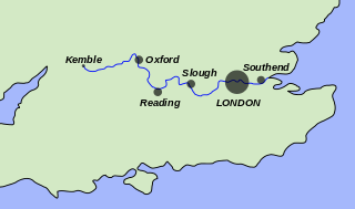
The River Thames, known alternatively in parts as the River Isis, is a river that flows through southern England including London. At 215 miles (346 km), it is the longest river entirely in England and the second-longest in the United Kingdom, after the River Severn.

Putney Bridge is a Grade II listed bridge over the River Thames in west London, linking Putney on the south side with Fulham to the north. The bridge has medieval parish churches beside its abutments: St Mary's Church, Putney is built on the south and All Saints Church, Fulham on the north bank. This close proximity of two churches by a major river is rare, another example being at Goring-on-Thames and Streatley, villages hemmed in by the Chiltern Hills. Before the first bridge was built in 1729, a ferry had shuttled between the two banks.

SouthwarkBridge is an arch bridge in London, for traffic linking the district of Southwark and the City across the River Thames. Besides when others are closed for temporary repairs, it has the least traffic of the Thames bridges in London.
Richmond Lock and Footbridge is a lock, rising and falling low-tide barrage integrating controlled sluices and pair of pedestrian bridges on the River Thames in south west London, England and is a Grade II* listed structure. It is the furthest downstream of the forty-five Thames locks and the only one owned and operated by the Port of London Authority. It was opened in 1894 and is north-west of the centre of Richmond in a semi-urban part of south-west London. Downstream are Syon Park and Kew Gardens on opposite banks. It connects the promenade at Richmond with the neighbouring district of St. Margarets on the west bank during the day and is closed at night to pedestrians – after 19:30 GMT or after 21:30 when BST is in use. At high tide the sluice gates are raised and partly hidden behind metal arches forming twin footbridges.

Sonning Eye is a hamlet on the River Thames in the Sonning Common ward of South Oxfordshire, England, in the civil parish of Eye & Dunsden, at what is since 1974 the southernmost tip of Oxfordshire.
Richmond Bridge is an 18th-century stone arch bridge that crosses the River Thames at Richmond, connecting the two halves of the present-day London Borough of Richmond upon Thames. It was designed by James Paine and Kenton Couse.
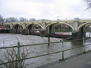
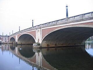
Kingston Bridge is a road bridge at Kingston upon Thames in south west London, England, carrying the A308 across the River Thames. It joins the town centre of Kingston in the Royal Borough of Kingston upon Thames to Hampton Court Park, Bushy Park, and the village of Hampton Wick in the London Borough of Richmond upon Thames. In 2005 it was carrying approximately 50,000 vehicles per day with up to 2,000 vehicles per hour in each direction during peak times.

Chiswick Bridge is a reinforced concrete deck arch bridge over the River Thames in West London. It is one of three bridges opened in 1933 as part of an ambitious scheme to relieve traffic congestion west of London. The structure carries the A316 road between Chiswick on the north bank of the Thames and Mortlake on the south bank.
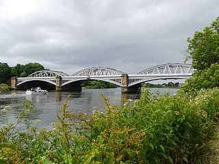
Barnes Railway Bridge is a Grade II listed railway bridge in the London Borough of Richmond upon Thames and the London Borough of Hounslow. It crosses the River Thames in London in a northwest to southeast direction at Barnes. It carries the South Western Railway's Hounslow Loop Line, and lies between Barnes Bridge and Chiswick stations. It can also be crossed on foot, and is one of only three bridges in London to combine pedestrian and rail use; the others being Hungerford Bridge and Golden Jubilee Bridges and Fulham Railway Bridge.
Hampton Court Bridge is a Grade II listed bridge that crosses the River Thames in England approximately north–south between Hampton, London and East Molesey, Surrey, carrying the A309. It is the upper of two road bridges on the reach above Teddington Lock and downstream of Molesey Lock.
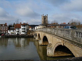
Henley Bridge is a road bridge built in 1786 at Henley-on-Thames over the River Thames, between Oxfordshire and Berkshire. The bridge has five elliptical stone arches, and links Hart Street in Henley with White Hill leading up a steep hill to Remenham Hill. It crosses the Thames on the reach between Hambleden Lock and Marsh Lock, carrying the Thames Path across the river. It is a Grade I listed building.

Molesey Lock is a lock on the River Thames in England at East Molesey, Surrey on the right bank.

Benson Lock is a lock on the River Thames in England, close to Benson, Oxfordshire but on the opposite bank of the river. The first pound lock here was built by the Thames Navigation Commission in 1788 and it was replaced by the present masonry lock in 1870. The distance between Benson Lock and Cleeve Lock downstream is 6.5 miles (10.4 km) - the longest distance between locks on the River Thames.

Osney Bridge is a road bridge across the River Thames in Oxford, England, built in 1888 to replace a stone bridge which collapsed in 1885. It carries the Botley Road (A420) from Botley into Oxford. The Thames Path crosses the river on this bridge, just above Osney Lock.

Staines Bridge is a road bridge running in a south-west to north-east direction across the River Thames in Surrey. It is on the modern A308 road and links the boroughs of Spelthorne and Runnymede at Staines-upon-Thames and Egham Hythe. The bridge is Grade II listed.

Cleeve Lock is a lock on the River Thames, in Oxfordshire, England. It is located just upstream of Goring and Streatley villages, on the eastern side of the river within the village of Goring. There was a hamlet of Cleeve, after which the lock is named, but it dropped out of use, as always part of Goring.

St John's Bridge is a two-section road bridge across the channel of the upper Thames near Lechlade, England, then across the lock cut to the south, the highest lock on the Thames. It is a Grade II listed building.

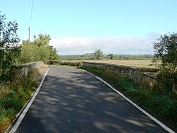
Castle Eaton is a village and civil parish in the ceremonial county of Wiltshire, England, on the River Thames about 4 miles (6.4 km) northwest of Highworth. It was historically in the area governed by the (former) Wiltshire County Council, but since 1997 has been part of the Swindon unitary authority. The Thames at Castle Eaton forms both the northern boundary of the parish and the county boundary with Gloucestershire.

Hannington is a village and civil parish in Wiltshire, England, two miles northwest of Highworth, and now part of the Borough of Swindon. The parish includes the hamlets of Hannington Wick and Swanborough. The nearest town is Swindon 5.5 miles and the County town of Wilshire, Trowbridge, is 29.5 miles. The River Thames forms both the northern boundary of the parish and the county boundary with Gloucestershire.

Sheepwash Channel connects the River Thames to the west and the Castle Mill Stream next to the Oxford Canal to the east, in west Oxford, England. To the north are Cripley Meadow and Fiddler's Island. To the south are Osney Island and the Botley Road.