The Thames and Severn Canal is a canal in Gloucestershire in the south-west of England, which was completed in 1789. It was conceived as part of a cargo route from Bristol and the Midlands to London, linking England's two largest rivers for better trade. The route climbs the steep Cotswold escarpment through the Golden Valley, tunnels underneath the summit of the Cotswold Edge, and emerges near the source of the Thames.

Lechlade is a town at the edge of the Cotswolds in Gloucestershire, England, 55 miles (89 km) south of Birmingham and 68 miles (109 km) west of London. It is the highest point at which the River Thames is navigable, although there is a right of navigation that continues south-west into Cricklade, in the neighbouring county of Wiltshire. The town is named after the River Leach that joins the Thames near the Trout Inn and St. John's Bridge.
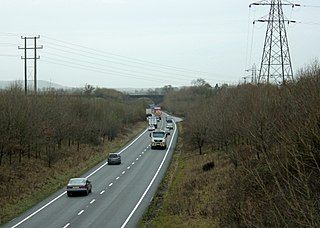
The A361 is an A class road in southern England, which at 195 miles (314 km) is the longest three-digit A road in the UK.
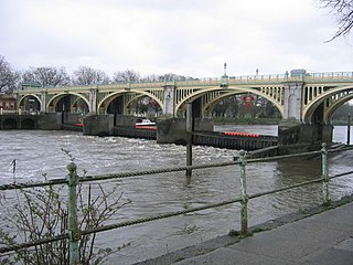
Richmond Lock and Footbridge is a lock, rising and falling low-tide barrage integrating controlled sluices and pair of pedestrian bridges on the River Thames in southwest London, England, and is a Grade II* listed structure. It is the furthest downstream of the forty-five Thames locks and the only one owned and operated by the Port of London Authority. It was opened in 1894 and is north-west of the centre of Richmond in a semi-urban part of southwest London. Downstream are Syon Park and Kew Gardens on opposite banks. It connects the promenade at Richmond with the neighbouring district of St. Margarets on the west bank during the day and is closed at night to pedestrians – after 19:30 GMT or after 21:30 when BST is in use. At high tide the sluice gates are raised and partly hidden behind metal arches forming twin footbridges.

The Windsor Bridge or Windsor Town Bridge, an iron and granite arch bridge over the River Thames, is located between the towns of Windsor and Eton in the English county of Berkshire. The Thames Path crosses the river here. The bridge carries pedestrian and cycle traffic, and crosses the Thames just above Romney Lock. It is a Grade II listed structure.

Whitchurch Bridge is a toll bridge that carries the B471 road over the River Thames in England. It links the villages of Pangbourne in Berkshire, and Whitchurch-on-Thames in Oxfordshire – crossing the river just downstream of Whitchurch Lock. It is one of two remaining private toll bridges across the Thames, the other being Swinford Toll Bridge. The bridge has a weight limit of 7.5 tonnes and is a Grade II listed structure. Its 1792-built, now unrelated, residential toll house is also listed.

Radcot Bridge is a crossing of the Thames in England, south of Radcot, Oxfordshire, and north of Faringdon, Oxfordshire which is in the district of that county that was in Berkshire. It carries the A4095 road across the reach above Radcot Lock. In many analyses it is a series of three bridges – before the northern one is reached, mainly to the east, is the smaller island hosting the Swan Inn. On the main north bank are slight earthworks forming a large square in which further remains have been found of Matilda's Castle and some Roman artefacts.
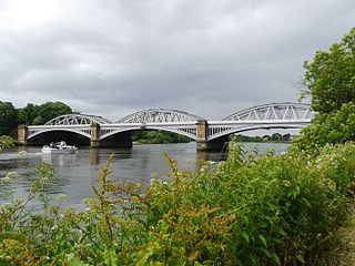
Barnes Railway Bridge is a Grade II listed railway bridge in the London Borough of Richmond upon Thames and the London Borough of Hounslow. It crosses the River Thames in London in a northwest to southeast direction at Barnes. It carries the South Western Railway's Hounslow Loop Line, and lies between Barnes Bridge and Chiswick stations. It can also be crossed on foot, and is one of only three bridges in London to combine pedestrian and rail use; the others being Hungerford Bridge and Golden Jubilee Bridges and Fulham Railway Bridge.

St John's Lock, below the town of Lechlade, Gloucestershire, is the furthest upstream lock on the River Thames in England. The name of the lock derives from a priory that was established nearby in 1250, but which no longer exists. The lock was built of stone in 1790 by the Thames Navigation Commission.

Newbridge is a 13th-century bridge carrying the Abingdon–Witney road over the River Thames in Oxfordshire, England, close to the Thames' confluence with the River Windrush. It is one of the two oldest surviving bridges on the Thames, part Grade I and part Grade II*-listed. The bridge is in a rural setting, with a public house at either end: the Maybush Inn on the south bank and the Rose Revived on the other. The bridge consists of two spans. The northern span crosses the river and the southern span, south of the Maybush, is dry underneath except when the river floods.

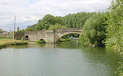
St John's Bridge is a two-section road bridge across the channel of the upper Thames near Lechlade, England, then across the lock cut to the south, the highest lock on the Thames. It is a Grade II listed building.

Farndon Bridge, also known as Holt Bridge, crosses the River Dee and the England-Wales border between the villages of Farndon, Cheshire, England and Holt, Wrexham, Wales. The bridge, which was built in the mid-14th century, is recorded in the National Heritage List for England and by Cadw as a designated Grade I listed building and scheduled monument. It is built from locally quarried red sandstone and had eight arches, of which five are over the river. On the Farndon side there is one flood arch and two flood arches are on the Holt side.

Hannington Bridge is a road bridge across the River Thames in England. It carries a minor road between Kempsford in Gloucestershire and Hannington Wick in Wiltshire. It was built of stone in 1841, replacing an earlier wooden bridge.

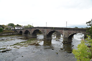
Cricklade Town Bridge is a road bridge at Cricklade, Wiltshire, England across the River Thames. It is a Grade II listed building.

Castle Eaton is a village and civil parish in the ceremonial county of Wiltshire, England, on the River Thames about 4 miles (6.4 km) northwest of Highworth. It was historically in the area governed by the (former) Wiltshire County Council, but since 1997 has been part of the Borough of Swindon. The Thames at Castle Eaton forms both the northern boundary of the parish and the county boundary with Gloucestershire.

Inglesham is a small village and civil parish in the Borough of Swindon, Wiltshire, England, notable for the Grade-I listed St John the Baptist Church. The village is just off the A361 road about 1 mile (1.6 km) south-west of Lechlade in Gloucestershire. Most of the population lives in the hamlet of Upper Inglesham, which is on the main road about 1.3 miles (2 km) south of the village.

Corby Bridge is a railway viaduct adjacent to and immediately east of Wetheral railway station at Wetheral, near Carlisle, in north-western England, begun in 1830 and completed in 1834. It is 920 feet (280 m) long and 100 feet (30 m) high, and has been a Grade I listed building since 1 April 1957.

The Trout Inn is a pub next to the River Thames at Lechlade, Gloucestershire, England. The Grade II listed stone building consists of two two-storey structures, one late medieval and the other added in the 18th century. The building began as an almshouse for workers on the adjoining St John's Bridge in the 1220s, before becoming part of a priory and then an inn.

The South Bank Lion is an 1837 sculpture in Central London. Since 1966 it has stood next to County Hall, on the South Bank of the River Thames. It is a significant depiction of a lion, along with the four that surround Nelson's Column in Trafalgar Square just across the river.
Penwortham Old Bridge is a toll-free, five-span bridge over the River Ribble at Preston, Lancashire, England. A Grade II listed structure and a scheduled monument, located about a mile southwest of the centre of the city, it crosses the river to Penwortham. Today the bridge no longer carries motorised traffic.