
Jersey County is a county located in the U.S. state of Illinois. At the 2020 census, it had a population of 21,512. The county seat and largest community is Jerseyville, with a population of 8,337 in 2010. The county's smallest incorporated community is Otterville, with a population of 87.

Calhoun County is a county in the U.S. state of Illinois. As of the 2020 census, the population was 4,437, making it Illinois’ third-least populous county. Its county seat and biggest community is Hardin, with a population of 801. Its smallest incorporated community is Hamburg, with a population of 99. Calhoun County is at the tip of the peninsula formed by the courses of the Mississippi and Illinois rivers above their confluence and is almost completely surrounded by water. Calhoun County is sparsely populated; it has just five municipalities, all of them villages.

Aurora is a city in northeastern Illinois, United States, located along the Fox River. The population was 180,542 at the 2020 census. It is the second-most populous city in Illinois, after Chicago, and the 144th-most populous city in the US. Aurora is the largest city in Illinois that is not the county seat of any county that it resides in.

Grafton is the oldest city in Jersey County, Illinois, United States. It is located near the confluence of the Illinois and Mississippi Rivers. As of the 2020 census, the city had a total population of 626. Prior to the Great Flood of 1993, Grafton had enjoyed a stable population of nearly 1,000 residents.

Jerseyville is the largest city in and the county seat of Jersey County, Illinois, United States. At the 2020 census, the city had a total population of 8,337.

Illinois Route 64 is an east–west state highway in Northern Illinois. Its western terminus is at the Iowa state line, connecting with U.S. Route 52 (US 52) and Iowa Highway 64 via the Dale Gardner Veterans Memorial Bridge at the Mississippi River west of Savanna. IL 64 then travels east through Mount Carroll, Lanark, Mount Morris, Oregon, Sycamore, Lily Lake, Saint Charles and the western suburbs of Chicago before terminating at U.S. Route 41 on the city's north side. IL 64 is 138.61 miles (223.07 km) long.

Illinois Route 38 is an 88.86-mile-long (143.01 km) west–east state highway that runs across northern Illinois. It runs from U.S. Route 52 (US 52) in downtown Dixon to US 12/US 20/US 45 in Westchester. It runs concurrently with the Lincoln Highway between Dixon and the junction of Illinois Route 31 in Geneva where it transitions via State Street onto Roosevelt Road at the junction of Kirk Road and continues through the western suburbs to its terminus at the junction of Mannheim Road. Roosevelt Road continues on an additional 14 miles without a route designation until terminating at US 41.

Illinois Route 111 (IL 111) is an 82.18-mile-long (132.26 km) north–south state highway in the southwestern part of the U.S. state of Illinois. It travels from Short Street in Centreville to IL 104 in Waverly.
Illinois Route 16 is an east–west highway in central Illinois. Its western terminus is at the Joe Page Bridge over the Illinois River in Hardin, while its eastern terminus is at Paris at Illinois Route 1 and U.S. Route 150, with Illinois Route 133. This is a distance of 174.66 miles (281.09 km).

Forgottonia, also spelled Forgotonia, is the name given to a 16-county region in Western Illinois in the late 1960s and early 1970s. This geographic region forms the distinctive western bulge of Illinois that is roughly equivalent to "The Tract", the Illinois portion of the Military Tract of 1812, along and west of the Fourth Principal Meridian. Since this wedge-shaped region lies between the Illinois and Mississippi rivers, it has historically been isolated from the eastern portion of Central Illinois.

Illinois Route 100 (IL-100) is a 159.09-mile-long (256.03 km) state highway in the southwest Illinois. It generally parallels the Illinois River. Starting in downtown Alton, it trends northward to Buckheart Township near Canton. It makes up much of the Illinois River Road, a U.S. National Scenic Byway.

Illinois Route 9 is a 218.31-mile-long (351.34 km) cross-state, east–west rural state highway in the central part of the U.S. state of Illinois. It travels from Niota at the Fort Madison Toll Bridge, that crosses the Mississippi River into Iowa, eastward across central Illinois to State Road 26 at the Indiana state line.
Illinois Route 106 (IL 106) is a 66.47-mile-long (106.97 km) east–west state highway in western Illinois. It runs from a new interchange with Interstate 72 (I-72) near East Hannibal to U.S. Route 67 in White Hall.

Illinois Route 109 is a 8.22-mile-long (13.23 km) minor north–south state road in southwest Illinois. It runs from Illinois Route 3 east of Newbern north to U.S. Route 67 in Jerseyville.

Illinois Route 267 (IL 267) is a north–south highway in the U.S. state of Illinois. It runs from U.S. Route 67 (US 67) and Illinois Route 111 in Godfrey north to Illinois Route 104 and Business Interstate 72 in Jacksonville. This is a distance of 59 miles (95 km). However, the state of Illinois' 2006 data shows the length of Illinois 267 as 39.46 miles (63.50 km), which is the distance from the Illinois 111/267 wye north to BL 72 at Illinois 104.

U.S. Route 24 (US 24) in the U.S. state of Illinois is a major arterial road that runs from the Missouri state line at the Mississippi River in Quincy to Sheldon. This is a distance of 255.13 miles (410.59 km).
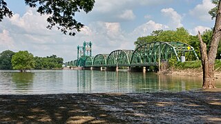
The Florence Bridge is a vertical-lift bridge that carries Illinois Route 100 (IL 100) and IL 106 across the Illinois River from Florence to Scott County, Illinois. The bridge is the middle of the three Illinois River crossings on IL 100, with the other two in Hardin and Beardstown. From its opening in 1929 until 1991, it carried U.S. Route 36 (US 36) and IL 100. In 1991, Interstate 72 (I-72) and the Valley City Eagle Bridges were completed 6 miles (9.7 km) upstream, and US 36 was designated onto I-72, with the old route signed as IL 106. The bridge was rehabilitated in 1981, and again in 2004. The second time, the bridge was closed due to the need to replace the deck. Traffic was detoured to I-72. In 2012, the bridge's lifting mechanism that allows barge traffic to pass under the bridge had serious problems, and continued use could affect the structural integrity of the span. Therefore, the span was raised and the bridge closed for nine months for repairs, using I-72 as a detour. The bridge reopened on April 22, 2013.
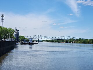
The Beardstown Bridge is a two-lane bridge that carries U.S. Route 67 (US 67) and Illinois Route 100 (IL 100) across the Illinois River between Schuyler County, Illinois and the city of Beardstown, Cass County, Illinois. The bridge was built in 1955 and rehabilitated in 1985. It is the northernmost and furthest upstream of the three Illinois River crossings used by IL 100, with the other two being at Florence and Hardin.
National Weather Service St. Louis is the National Weather Service office located in St. Charles, Missouri, just outside St. Louis, Missouri. There are 46 counties in its County Warning Area (CWA). Some of the cities in its CWA are Columbia, Farmington, Hannibal and Jefferson City in Missouri, and Belleville, Centralia, Edwardsville, and Quincy in Illinois.
U.S. Route 67 (US 67) is a component of the United States Numbered Highway System that connects Presidio, Texas, to Sabula, Iowa. In Illinois, it serves the western region of the state known as Forgottonia, named for the lack of regional transportation and infrastructure projects. The highway begins its path through the state by crossing the Clark Bridge over the Mississippi River from Missouri at Alton and heads northward through Jerseyville and Jacksonville before it crosses the Illinois River at Beardstown. The northern half of the route serves Macomb and Monmouth before it enters the Quad Cities. It leaves the state at Rock Island by crossing the Rock Island Centennial Bridge over the Mississippi River into Davenport, Iowa.


