List of crossings of the Illinois River

Last updated

This is a list of bridges and other crossings of the Illinois River from the Mississippi River upstream to the confluence of the Kankakee and Des Plaines Rivers.

CrossingCarriesLocationCoordinates
Brussels Ferry [1] Point Pct., Calhoun Co. and Quarry Twp., Jersey Co. west of Grafton 38°57′54.69″N90°29′41.40″W / 38.9651917°N 90.4948333°W / 38.9651917; -90.4948333
Hardin Bridge Illinois 16.svgIllinois 100.svg IL 16  / IL 100 Hardin 39°09′36.23″N90°36′48.61″W / 39.1600639°N 90.6135028°W / 39.1600639; -90.6135028
Kampsville Ferry [1] Illinois 108.svg IL 108 Kampsville 39°17′59.04″N90°36′20.78″W / 39.2997333°N 90.6057722°W / 39.2997333; -90.6057722
Rail bridge Kansas City Southern Railway
originally Alton Railroad
Pearl 39°27′26.55″N90°36′37.15″W / 39.4573750°N 90.6103194°W / 39.4573750; -90.6103194
Florence Bridge Illinois 100.svgIllinois 106.svg IL 100  / IL 106 Florence 39°37′57.30″N90°36′26.36″W / 39.6325833°N 90.6073222°W / 39.6325833; -90.6073222
Valley City Eagle Bridges I-72.svgUS 36.svg I-72  / US 36 Valley City 39°41′13.34″N90°38′28.43″W / 39.6870389°N 90.6412306°W / 39.6870389; -90.6412306
Rail bridge Norfolk Southern Railway
originally Wabash Railroad
Valley City 39°41′12.01″N90°38′45.33″W / 39.6866694°N 90.6459250°W / 39.6866694; -90.6459250
Rail bridge (removed 1959) Wabash Railroad
originally Northern Cross Railroad
Meredosia 39°49′34″N90°33′51″W / 39.82611°N 90.56417°W / 39.82611; -90.56417
Meredosia Bridge Illinois 104.svg IL 104 Meredosia 39°49′50.30″N90°33′55.92″W / 39.8306389°N 90.5655333°W / 39.8306389; -90.5655333
Beardstown Bridge US 67.svgIllinois 100.svg US 67  / IL 100 Beardstown 40°00′54.67″N90°26′48.70″W / 40.0151861°N 90.4468611°W / 40.0151861; -90.4468611
Rail bridge BNSF Railway
originally Chicago, Burlington and Quincy Railroad
Beardstown 40°01′22.61″N90°26′00.42″W / 40.0229472°N 90.4334500°W / 40.0229472; -90.4334500
Scott W. Lucas Bridge US 136.svgIllinois 78.svgIllinois 97.svg US 136  / IL 78  / IL 97 Havana 40°17′38.92″N90°04′08.24″W / 40.2941444°N 90.0689556°W / 40.2941444; -90.0689556
Rail bridge Union Pacific Railroad
originally Chicago & North Western Railroad
Pekin 40°33′14.67″N89°40′30.78″W / 40.5540750°N 89.6752167°W / 40.5540750; -89.6752167
John T. McNaughton Bridge Illinois 9.svg IL 9 Pekin 40°34′25.07″N89°39′15.43″W / 40.5736306°N 89.6542861°W / 40.5736306; -89.6542861
Shade-Lohmann Bridge I-474.svgUS 24.svg I-474  / US 24 Bartonville and Creve Coeur 40°38′05.86″N89°37′20.89″W / 40.6349611°N 89.6224694°W / 40.6349611; -89.6224694
Rail bridge Peoria and Pekin Union Railway
Tazewell and Peoria Railroad
Toledo, Peoria and Western Railway
Peoria and East Peoria 40°40′03.40″N89°36′40.59″W / 40.6676111°N 89.6112750°W / 40.6676111; -89.6112750
Cedar Street Bridge Illinois 8.svgIllinois 116.svg IL 8  / IL 116 (and Illinois 29.svg IL 29 until 2012) 40°40′38.42″N89°36′00.84″W / 40.6773389°N 89.6002333°W / 40.6773389; -89.6002333
Bob Michel Bridge Illinois 40.svg IL 40 40°41′04.33″N89°35′30.45″W / 40.6845361°N 89.5917917°W / 40.6845361; -89.5917917
Murray Baker Bridge I-74.svgIllinois 29.svg I-74  / IL 29 40°41′16.29″N89°35′00.13″W / 40.6878583°N 89.5833694°W / 40.6878583; -89.5833694
McClugage Bridge US 150.svg US 150 (and US 24.svg US 24 until 2012) 40°43′11.08″N89°32′40.27″W / 40.7197444°N 89.5445194°W / 40.7197444; -89.5445194
Rail bridge BNSF Railway
originally Atchison, Topeka and Santa Fe Railway
Chillicothe 40°55′44.43″N89°27′40.40″W / 40.9290083°N 89.4612222°W / 40.9290083; -89.4612222
Lacon Bridge Illinois 17.svg IL 17 Sparland and Lacon 41°01′32.43″N89°25′00.28″W / 41.0256750°N 89.4167444°W / 41.0256750; -89.4167444
Henry Bridge Illinois 18.svg IL 18 Henry 41°06′29.89″N89°21′07.68″W / 41.1083028°N 89.3521333°W / 41.1083028; -89.3521333
Hennepin Bridge (removed 1969?)Illinois 26.svg IL 26 Hennepin 41°15′26.29″N89°20′57.26″W / 41.2573028°N 89.3492389°W / 41.2573028; -89.3492389
Gudmund "Sonny" Jessen Bridge I-180.svgIllinois 26.svg I-180  / IL 26 41°15′39.13″N89°20′50.79″W / 41.2608694°N 89.3474417°W / 41.2608694; -89.3474417
Rail bridge (removed ? date) Norfolk Southern Railway
originally New York Central Railroad Illinois Division Kankakee Belt Route
De Pue 41°18′50.87″N89°16′43.02″W / 41.3141306°N 89.2786167°W / 41.3141306; -89.2786167
Spring Valley Bridge Illinois 89.svg IL 89 Spring Valley 41°18′43.62″N89°11′59.82″W / 41.3121167°N 89.1999500°W / 41.3121167; -89.1999500
Peru Bridge Illinois 251.svg IL 251 Peru 41°19′25.80″N89°07′12.48″W / 41.3238333°N 89.1201333°W / 41.3238333; -89.1201333
Shippingsport Bridge Illinois 351.svg IL 351 LaSalle and Oglesby 41°18′52.05″N89°05′30.57″W / 41.3144583°N 89.0918250°W / 41.3144583; -89.0918250
Rail bridge Buzzi Unicem Railspur
originally Illinois Central Railroad
41°19′20.63″N89°04′59.48″W / 41.3223972°N 89.0831889°W / 41.3223972; -89.0831889
Abraham Lincoln Memorial Bridge I-39.svgUS 51.svg I-39  / US 51 41°19′29.35″N89°04′37.43″W / 41.3248194°N 89.0770639°W / 41.3248194; -89.0770639
Utica Bridge Illinois 178.svg IL 178 Utica 41°19′37.67″N89°00′38.31″W / 41.3271306°N 89.0106417°W / 41.3271306; -89.0106417
Ottawa Rail Bridge Illinois Railway
formerly BNSF Railway and Chicago, Burlington and Quincy Railroad
Ottawa 41°19′22.85″N88°42′36.61″W / 41.3230139°N 88.7101694°W / 41.3230139; -88.7101694
Veterans Memorial Bridge Illinois 23.svgIllinois 71.svg IL 23  / IL 71 41°19′22.85″N88°42′36.61″W / 41.3230139°N 88.7101694°W / 41.3230139; -88.7101694
Marseilles Bridge LaSalle County Highway 15 (Main Street) Marseilles 41°20′32.22″N88°50′27.04″W / 41.3422833°N 88.8408444°W / 41.3422833; -88.8408444
Seneca Bridge Illinois 170.svg IL 170 Seneca 41°17′56.80″N88°36′33.01″W / 41.2991111°N 88.6091694°W / 41.2991111; -88.6091694
Seneca Rail Bridge CSX Transportation
formerly Kankakee and Seneca Railroad, jointly owned by Chicago, Rock Island and Pacific Railroad and Cleveland, Cincinnati, Chicago and St. Louis Railway
41°18′21.53″N88°35′9.29″W / 41.3059806°N 88.5859139°W / 41.3059806; -88.5859139
Morris Bridge Illinois 47.svg IL 47 Morris 41°21′13.44″N88°25′17.39″W / 41.3537333°N 88.4214972°W / 41.3537333; -88.4214972
Rail lift bridge Elgin, Joliet and Eastern Railway Aux Sable Twp., Grundy Co.

Upstream, the Illinois River starts as the merger of the Des Plaines River and the Kankakee River.

Related Research Articles

Illinois River Illinois tributary of the Mississippi River in the United States

The Illinois River is a principal tributary of the Mississippi River and is approximately 273 miles (439 km) long. Located in the U.S. state of Illinois, the river drains a large section of central Illinois, with a drainage basin of 28,756.6 square miles (74,479 km2). The drainage basin extends into Wisconsin, Indiana, and a very small area of southwestern Michigan.

Will County, Illinois County in Illinois, United States

Will County is a county in the northeastern part of the state of Illinois. According to the 2020 census, it had a population of 696,355, an increase of 2.8% from 677,560 in 2010, making it Illinois's fourth-most populous county. The county seat is Joliet. Will County is one of the five collar counties of the Chicago-Naperville-Elgin, IL-IN-WI Metropolitan Statistical Area. The portion of Will County around Joliet uses the 815 and 779 area codes, 630 and 331 are for far northern Will County, and 708 is for central and eastern Will County.
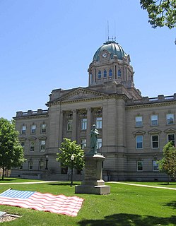
Kankakee, Illinois City in the United States

Kankakee is a city in and the county seat of Kankakee County, Illinois, United States. As of 2020, the city's population was 24,052. The city's name is probably derived from the Miami-Illinois word teeyaahkiki, meaning: "Open country/exposed land/land in open/land exposed to view", in reference to the area's prior status as a marsh. Kankakee is a principal city of the Kankakee-Bourbonnais-Bradley Metropolitan Statistical Area. It serves as an anchor city in the rural plains outside Chicago, similar to Aurora and Joliet.

Louis Jolliet Explorer of North America (1645–1700)

Louis Jolliet was a French-Canadian explorer known for his discoveries in North America. In 1673, Jolliet and Jacques Marquette, a Jesuit Catholic priest and missionary, were the first non-Natives to explore and map the Upper Mississippi River.

U.S. Route 45

U.S. Route 45 is a major north-south United States highway and a border-to-border route, from Lake Superior to the Gulf of Mexico. A sign at the highway's northern terminus notes the total distance as 1,297 miles (2,087 km).

Kankakee River River in Indiana and Illinois, United States

The Kankakee River is a tributary of the Illinois River, approximately 133 miles (214 km) long, in the Central Corn Belt Plains of northwestern Indiana and northeastern Illinois in the United States. At one time, the river drained one of the largest wetlands in North America and furnished a significant portage between the Great Lakes and the Mississippi River. Significantly altered from its original channel, it flows through a primarily rural farming region of reclaimed cropland, south of Lake Michigan.

Illinois Route 17 is a rural, arterial east–west state road that runs east from a former ferry crossing in New Boston along the banks of the Mississippi River to State Road 2 west of Lowell, Indiana. It is 209.40 miles (337.00 km) long.
Kankakee may refer to

Des Plaines River Tributary of the Illinois River

The Des Plaines River is a river that flows southward for 133 miles (214 km) through southern Wisconsin and northern Illinois in the United States Midwest, eventually meeting the Kankakee River west of Channahon to form the Illinois River, a tributary of the Mississippi River.

Iroquois River (Indiana-Illinois)

The Iroquois River is a 103-mile-long (166 km) tributary of the Kankakee River in the Central Corn Belt Plains of northwestern Indiana and northeastern Illinois in the United States. It was named for the Iroquois people. Via the Kankakee and Illinois rivers, it is part of the watershed of the Mississippi River.

Upper Mississippi River Upstream portion of the Mississippi river

The Upper Mississippi River is the portion of the Mississippi River upstream of St. Louis, Missouri, United States, at the confluence of its main tributary, the Missouri River.

Watersheds of Illinois is a list of basins or catchment areas into which the State of Illinois can be divided based on the place to which water flows.

The geology of Illinois includes extensive deposits of marine sedimentary rocks from the Palaeozoic, as well as relatively minor contributions from the Mesozoic and Cenozoic. Ice age glaciation left a wealth of glacial topographic features throughout the state.

U.S. Route 45 in the state of Illinois is a major north–south U.S. Highway that runs from the Brookport Bridge over the Ohio River at Brookport north through rural sections of eastern Illinois and then through the suburbs of Chicago to the Wisconsin state line east of Antioch. This is a distance of 428.99 miles (690.39 km). US 45 is the longest numbered route in Illinois.

Yellow River (Indiana)

The Yellow River is a 62.3-mile-long (100.3 km) tributary of the Kankakee River in the Central Corn Belt Plains ecoregion, located in northern Indiana in the United States. Via the Kankakee and Illinois rivers, it is part of the watershed of the Mississippi River, draining an area of 427 square miles (1,110 km2). The river's name possibly derives from a translation of the Shawnee name for the river, We-thau-ka-mik, meaning "yellow waters", a description perhaps owing to the presence of sand in the riverbed.

Des Plaines Fish and Wildlife Area

Des Plaines Fish and Wildlife Area is an Illinois state park on 5,000 acres (2,023 ha) in Will County, Illinois, United States. It is located on floodplain adjacent to the confluence of the Des Plaines River and the Kankakee River to form the Illinois River.

Valparaiso Moraine Moraine in Indiana

The Valparaiso Moraine is a recessional moraine that forms an immense U around the southern Lake Michigan basin in North America. It is a band of hilly terrain composed of glacial till and sand. The Valparaiso Moraine forms part of the Saint Lawrence River Divide, bounding the Great Lakes Basin. It begins near the border of Wisconsin and Illinois and extends south through Lake, McHenry, Cook, DuPage and Will counties in Illinois, and then turns southeast, entering Indiana. From this point, the moraine curves northeast through Lake, Porter, and LaPorte counties of Indiana into Michigan. It continues into Michigan as far as Montcalm County.

Kankakee Torrent

The Kankakee Torrent was a catastrophic flood that occurred about 19,000 calibrated years ago in the Midwestern United States. It resulted from a breach of moraines forming a large glacial lake fed by the melting of the Late Wisconsin Laurentide Ice Sheet. The point of origin of the flood was Lake Chicago. The landscape south of Chicago still shows the effects of the torrent, particularly at Kankakee River State Park and on the Illinois River at Starved Rock State Park.
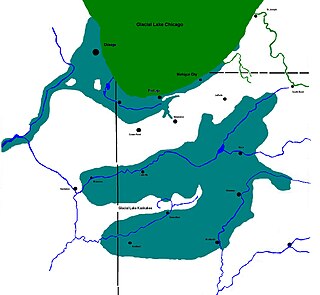
Lake Kankakee

Lake Kankakee formed 14,000 years before present (YBP) in the valley of the Kankakee River. It developed from the outwash of the Michigan Lobe, Saginaw Lobe, and the Huron-Erie Lobe of the Wisconsin glaciation. These three ice sheets formed a basin across Northwestern Indiana. It was a time when the glaciers were receding, but had stopped for a thousand years in these locations. The lake drained about 13,000 YBP, until reaching the level of the Momence Ledge. The outcropping of limestone created an artificial base level, holding water throughout the upper basin, creating the Grand Kankakee Marsh.

References

  1. 1 2 "IDOT Operated Ferries". Illinois Department of Transportation . Retrieved 2014-04-10.

See also