The Great River Road is a collection of state and local roads that follow the course of the Mississippi River through ten states of the United States. They are Minnesota, Wisconsin, Iowa, Illinois, Missouri, Kentucky, Tennessee, Arkansas, Mississippi and Louisiana. It formerly extended north into Canada, serving the provinces of Ontario and Manitoba. The road is designated as both a National Scenic Byway and an All-American Road in several states along the route.

Interstate 94 (I-94) is an east–west Interstate Highway connecting the Great Lakes and northern Great Plains regions of the United States. Its western terminus is just east of Billings, Montana, at a junction with I-90; its eastern terminus is in Port Huron, Michigan, where it meets with I-69 and crosses the Blue Water Bridge into Sarnia, Ontario, Canada, where the route becomes Ontario Highway 402. It thus lies along the primary overland route from Seattle to Toronto and is the only east–west Interstate Highway to have a direct connection to Canada.

A bridge to nowhere is a bridge where one or both ends are broken, incomplete, or unconnected to any roads. If it is an overpass or an interchange, the term overpass to nowhere or interchange to nowhere may be used respectively.

A swing bridge is a movable bridge that can be rotated horizontally around a vertical axis. It has as its primary structural support a vertical locating pin and support ring, usually at or near to its center of gravity, about which the swing span can then pivot horizontally as shown in the animated illustration to the right.

The Eads Bridge is a combined road and railway bridge over the Mississippi River connecting the cities of St. Louis, Missouri, and East St. Louis, Illinois. It is located on the St. Louis riverfront between Laclede's Landing to the north, and the grounds of the Gateway Arch to the south. The bridge is named for its designer and builder, James Buchanan Eads. Work on the bridge began in 1867, and it was completed in 1874. The Eads Bridge was the first bridge across the Mississippi south of the Missouri River. Earlier bridges were located north of the Missouri, where the Mississippi is smaller. None of the earlier bridges survived, which means that the Eads Bridge is also the oldest bridge on the river.

U.S. Highway 151 (US 151) is a United States Numbered Highway that runs through the states of Iowa and Wisconsin. The southern terminus for US 151 is at a junction with Interstate 80 (I-80) in Iowa County, Iowa, and its northern terminus is at Manitowoc, Wisconsin. The route, from south to north follows a northeasterly path through the two states.

The Broadway Bridge is a vertical-lift bridge across the Harlem River Ship Canal in the borough of Manhattan in New York City. It connects the neighborhoods of Inwood on Manhattan Island and Marble Hill on the mainland. The bridge consists of two decks. The lower deck carries Broadway, which is designated as U.S. Route 9 at this location. The upper deck carries the New York City Subway's IRT Broadway–Seventh Avenue Line, serving the 1 train.

Route 158 was a short state highway in Newark and Harrison, New Jersey, in the counties of Essex and Hudson, which are located in the United States. The Centre Street Bridge was first constructed in 1834 as a single-level railroad bridge. However, in 1911, almost eight decades later, a second, upper level was constructed for rapid transit. In 1937, the Hudson and Manhattan Railroad, now part of the Port Authority Trans-Hudson line, was realigned onto railroad tracks along New Jersey Route 21. The upper level of the bridge was abandoned for this purpose, and was later converted to roadway. At the western end in Newark it ran just south of Park Place, beginning at Center Street. The route headed eastward, crossing over Route 21 and the Passaic River before entering Harrison, where it terminated at Second Street north of New Jersey Railroad Avenue.

Downtown Portland is the central business district of Portland, Oregon, United States. It is on the west bank of the Willamette River in the northeastern corner of the southwest section of the city and where most of the city's high-rise buildings are found.
The Macombs Dam Bridge is a swing bridge across the Harlem River in New York City, connecting the boroughs of Manhattan and the Bronx. The bridge is operated and maintained by the New York City Department of Transportation (NYCDOT).

The OC&E Woods Line State Trail is a rail trail in Klamath and Lake counties in the U.S. state of Oregon. It is Oregon's longest state park. The trail follows the old OC&E and Weyerhaeuser railroads from Klamath Falls to Thompson Reservoir. Along its 105-mile (169 km) length it passes through the communities of Olene, Sprague River, Dairy, Beatty, and Bly.

U.S. Route 66 was a United States Numbered Highway in Illinois that connected St. Louis, Missouri, and Chicago, Illinois. The historic Route 66, the Mother Road or Main Street of America, took long distance automobile travelers from Chicago to Southern California. The highway had previously been Illinois Route 4 and the road has now been largely replaced with Interstate 55 (I-55). Parts of the road still carry traffic and six separate portions of the roadbed have been listed on the National Register of Historic Places.

U.S. Highway 90 Business is a business route of U.S. Highway 90 located in and near New Orleans, Louisiana. It runs 14.25 miles (22.93 km) in a general east–west direction from US 90 in Avondale to a junction with Interstate 10 (I-10) and US 90 in the New Orleans Central Business District.

The West Philadelphia Elevated, also known as the High Line or Philadelphia High Line, is a railroad viaduct in the western part of Philadelphia, Pennsylvania. Now part of the Harrisburg Subdivision of CSX Transportation, the viaduct was built in 1903 by the Pennsylvania Railroad (PRR) to allow through freight trains to bypass rail yard, industrial sidings, and a passenger station.

The Cornish–Windsor Covered Bridge is a 158-year-old, two-span, timber Town lattice-truss, interstate, covered bridge that crosses the Connecticut River between Cornish, New Hampshire, and Windsor, Vermont. Until 2008, when the Smolen–Gulf Bridge opened in Ohio, it had been the longest covered bridge in the United States.

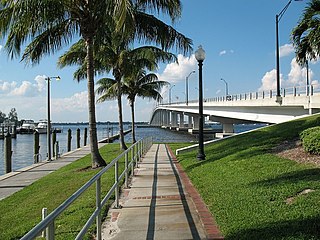
The Edison Bridge is a set of two one-way bridges located in Fort Myers, Florida. Named after inventor Thomas Alva Edison, the two bridges carry each direction of U.S. Highway 41 Business over the Caloosahatchee River, connecting downtown Fort Myers with North Fort Myers.

U.S. Route 64 is a U.S. route running from Teec Nos Pos, Arizona east to Nags Head, North Carolina. In the U.S. state of Arkansas, the route runs 246.35 miles (396.46 km) from the Oklahoma border in Fort Smith east to the Tennessee border in Memphis. The route passes through several cities and towns, including Fort Smith, Clarksville, Russellville, Conway, Searcy, and West Memphis. US 64 runs parallel to Interstate 40 (I-40) until Conway, when I-40 takes a more southerly route.

The Canal Street railroad bridge is a vertical-lift bridge across the south branch of the Chicago River in Chicago, Illinois. It was designated a Chicago Landmark on December 12, 2007.

U.S. Highway 136 (US 136) is a short U.S. Highway in Keokuk, Iowa. The route was designated nationally in 1951 and has remained largely unchanged through Keokuk since then. The highway originally crossed the Mississippi on the Keokuk Rail Bridge, which was the second bridge built and operated by Andrew Carnegie's Keokuk & Hamilton Bridge Company in that location. While it was designed for wagons and early automobiles, crossing the rail bridge became difficult in larger modern vehicles, specifically semi trucks. As a result, a new automobile-only bridge was built directly to the south of the older span. The Keokuk–Hamilton Bridge opened in 1985 eight months early and under budget.


