
The Illinois and Michigan Canal connected the Great Lakes to the Mississippi River and the Gulf of Mexico. In Illinois, it ran 96 miles (154 km) from the Chicago River in Bridgeport, Chicago to the Illinois River at LaSalle-Peru. The canal crossed the Chicago Portage, and helped establish Chicago as the transportation hub of the United States, before the railroad era. It was opened in 1848. Its function was partially replaced by the wider and deeper Chicago Sanitary and Ship Canal in 1900, and it ceased transportation operations with the completion of the Illinois Waterway in 1933.

The Great River Road is a collection of state and local roads that follow the course of the Mississippi River through ten states of the United States. They are Minnesota, Wisconsin, Iowa, Illinois, Missouri, Kentucky, Tennessee, Arkansas, Mississippi and Louisiana. It formerly extended north into Canada, serving the provinces of Ontario and Manitoba. The road is designated as both a National Scenic Byway and an All-American Road in several states along the route.

The Illinois River is a principal tributary of the Mississippi River at approximately 273 miles (439 km) in length. Located in the U.S. state of Illinois, the river has a drainage basin of 28,756.6 square miles (74,479 km2). The Illinois River begins with the confluence of the Des Plaines and Kankakee rivers in the Chicago metropolitan area, and it generally flows to the southwest across Illinois, until it empties into the Mississippi near Grafton, Illinois. Its drainage basin extends into southeastern Wisconsin, northwestern Indiana, and a very small area of southwestern Michigan in addition to central Illinois. Along its shores are several river ports, including Peoria, Illinois. Historic and recreation areas on the river include Starved Rock, and the internationally important wetlands of the Emiquon Complex and Dixon Waterfowl Refuge.
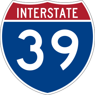
Interstate 39 (I-39) is a highway in the Midwestern United States. I-39 runs from Normal, Illinois, at I-55 to State Trunk Highway 29 (WIS 29) in the village of Rib Mountain, Wisconsin, which is approximately six miles (9.7 km) south of Wausau. I-39 was designed to replace U.S. Route 51 (US 51), which, in the early 1980s, was one of the busiest two-lane highways in the United States. I-39 was built in the 1980s and 1990s.

LaSalle County is a county located within the Fox Valley and Illinois River Valley regions of the U.S. state of Illinois. As of the 2020 Census, it had a population of 109,658. Its county seat and largest city is Ottawa. LaSalle County is part of the Ottawa, IL Micropolitan Statistical Area of Northern Illinois.
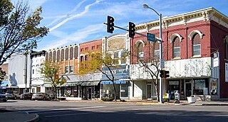
LaSalle or La Salle is a city in LaSalle County, Illinois, United States, located at the intersection of Interstates 39 and 80. It is part of the Ottawa, IL Micropolitan Statistical Area. Originally platted in 1837 over one square mile, the city's boundaries have grown to 12 sq mi (31 km2). Named in honor of 17th century Illinois valley explorer, the Sieur de La Salle, City boundaries extend from the Illinois River and Illinois and Michigan Canal to a mile north of Interstate 80 and from the city of Peru on the west to the village of North Utica on the east. Starved Rock State Park is located approximately 5 mi (8 km) to the east. The population was 9,582 as of the 2020 census, down from 9,609 at the 2010 census. LaSalle and its twin city, Peru, make up the core of the Illinois Valley. Due to their combined dominance of the zinc processing industry in the early 1900s, they were collectively nicknamed "Zinc City."

Illinois Route 71 is a 66-mile-long (106 km) southwest-to-northeast state highway in north central Illinois. It runs from the end of Interstate 180 in Hennepin to U.S. Route 34 in Oswego. This is a distance of 69.37 miles (111.64 km).

Illinois Route 64 is an east–west state highway in Northern Illinois. Its western terminus is at the Iowa state line, connecting with U.S. Route 52 (US 52) and Iowa Highway 64 via the Dale Gardner Veterans Memorial Bridge at the Mississippi River west of Savanna. IL 64 then travels east through Mount Carroll, Lanark, Mount Morris, Oregon, Sycamore, Lily Lake, Saint Charles and the western suburbs of Chicago before terminating at U.S. Route 41 on the city's north side. IL 64 is 138.61 miles (223.07 km) long.

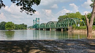
Abraham Lincoln Memorial Bridge in Illinois is a four-lane bidirectional road bridge that spans the Illinois River, Illinois Route 351, Illinois and Michigan Canal, and local roads and railroads. It carries Interstate 39 (I-39), a major north-south Interstate through central Illinois, and its U.S. Route counterpart, U.S. Route 51 (US 51).

Illinois Route 351 is a north–south state route that leads from Illinois Route 71 and Illinois Route 251 by Oglesby through downtown LaSalle to Interstate 80. It is 8.55 miles (13.76 km) long.

The Government Bridge or Arsenal Bridge spans the Mississippi River, connecting Rock Island, Illinois and Davenport, Iowa. The Iowa Interstate Railroad uses the upper deck of the bridge for its ex-Chicago and Rock Island Railroad route between Council Bluffs, Iowa and Chicago, Illinois. The lower deck carries automobile traffic between the two cities. It is located near Upper Mississippi Mile Marker 483, adjacent to the Mississippi River Lock and Dam No. 15. The current structure is the fourth at this location. The bridges all were built with a swing section to accommodate traffic navigating the river.

Illinois Route 178 is a minor north–south state highway in north central Illinois. It runs north from the unincorporated area of Lowell to Interstate 80 about 3 miles (4.8 km) north of North Utica, which is better known as simply Utica. This is a distance of 8.49 miles (13.66 km).

The La Crosse Rail Bridge is a swing bridge that spans the Mississippi River between La Crescent, Minnesota and La Crosse, Wisconsin. The first bridge in this location initially was designed and ready to build by June 1876, and was completed in November 1876 by the Milwaukee and St. Paul Railway, a predecessor of the Chicago, Milwaukee, St. Paul and Pacific Railroad. It was later replaced in 1902. It is at the Western end of the Canadian Pacific Railway Tomah Subdivision. Amtrak's Empire Builder crosses this bridge.

The North Avenue Bridge can refer to one of three bridges that has carried North Avenue over the North Branch of the Chicago River on the north side of Chicago, Illinois. A center-pier swing bridge built in 1877 was replaced in 1907 by a bascule bridge, allowing river traffic more room for maneuvering in and out of the North Canal, just north of Goose Island.

The Fourteenth Street Bridge, also known as the Ohio Falls Bridge, Pennsylvania Railroad Bridge, Conrail Railroad Bridge or Louisville and Indiana (L&I) Bridge, is a truss drawbridge that spans the Ohio River, between Louisville, Kentucky and Clarksville, Indiana.

The Canal Street railroad bridge is a vertical-lift bridge across the south branch of the Chicago River in Chicago, Illinois. It was designated a Chicago Landmark on December 12, 2007.
The Florence Bridge is a vertical-lift bridge that carries Illinois Route 100 (IL 100) and IL 106 across the Illinois River from Florence to Scott County, Illinois. The bridge is the middle of the three Illinois River crossings on IL 100, with the other two in Hardin and Beardstown. From its opening in 1929 until 1991, it carried U.S. Route 36 (US 36) and IL 100. In 1991, Interstate 72 (I-72) and the Valley City Eagle Bridges were completed 6 miles (9.7 km) upstream, and US 36 was designated onto I-72, with the old route signed as IL 106. The bridge was rehabilitated in 1981, and again in 2004. The second time, the bridge was closed due to the need to replace the deck. Traffic was detoured to I-72. In 2012, the bridge's lifting mechanism that allows barge traffic to pass under the bridge had serious problems, and continued use could affect the structural integrity of the span. Therefore, the span was raised and the bridge closed for nine months for repairs, using I-72 as a detour. The bridge reopened on April 22, 2013.

Lake Shore and Michigan Southern Railway, Bridge No. 6 is a steel vertical-lift bridge consisting of two parallel spans, carrying two tracks each, across the Calumet River in Chicago, Illinois, United States. The structure is currently owned by Norfolk Southern Railway but disused and kept in a raised position.

William Donald Scherzer was an American engineer and inventor who invented the rolling lift bridge.


