
Interstate 24 (I-24) is an Interstate Highway in the Midwestern and Southeastern United States. It runs diagonally from I-57, 10 miles (16 km) south of Marion, Illinois, to Chattanooga, Tennessee, at I-75. It travels through Illinois, Kentucky, Tennessee, and Georgia. As an even-numbered Interstate, it is signed as an east–west route, though the route follows a more southeast–northwest routing, passing through Nashville, Tennessee. The numbering deviates from the standard Interstate Highway System grid, lying further north than its number would indicate west of Nashville. The short segment within Georgia bears the unsigned designation State Route 409 (SR 409).
Interstate 39 (I-39) is a highway in the Midwestern United States. I-39 runs from Normal, Illinois, at I-55 to State Trunk Highway 29 (WIS 29) in the village of Rib Mountain, Wisconsin, which is approximately six miles (9.7 km) south of Wausau. I-39 was designed to replace U.S. Route 51 (US 51), which, in the early 1980s, was one of the busiest two-lane highways in the United States. I-39 was built in the 1980s and 1990s.
Interstate 90 (I-90) is an east–west transcontinental freeway and the longest Interstate Highway in the United States at 3,021 miles (4,862 km). It begins in Seattle, Washington, and travels through the Pacific Northwest, Mountain West, Great Plains, Midwest, and the Northeast, ending in Boston, Massachusetts. The highway serves 13 states and has 15 auxiliary routes, primarily in major cities such as Chicago, Cleveland, Buffalo, and Rochester.
Interstate 72 (I-72) is an Interstate Highway in the Midwestern United States. Its western terminus is in Hannibal, Missouri, at an intersection with U.S. Route 61 (US 61); its eastern terminus is at Country Fair Drive in Champaign, Illinois. The route runs through the major cities of Decatur, Illinois, and Springfield, Illinois. In 2006, the Illinois General Assembly dedicated all of I-72 as Purple Heart Memorial Highway. The stretch between Springfield and Decatur is also called Penny Severns Memorial Expressway, and the section between mile 35 and the Mississippi River is known as the Free Frank McWorter Historic Highway.

M-26 is a 96.355-mile-long (155.068 km) state trunkline highway in the U.S. state of Michigan, running from two miles (3.2 km) east of Rockland to its junction with US Highway 41 (US 41) in Copper Harbor. It generally runs southwest-to-northeast in the western half or Michigan's Upper Peninsula. The northernmost segment, which closely parallels the shore of Lake Superior on the west side of the Keweenaw Peninsula, is highly scenic.
The Avenue of the Saints is a 563-mile-long (906 km) highway in the Midwestern United States that connects St. Louis, Missouri, and St. Paul, Minnesota.

U.S. Route 54 is an east–west United States Highway that runs northeast–southwest for 1,197 miles (1,926 km) from El Paso, Texas, to Griggsville, Illinois. The Union Pacific Railroad's Tucumcari Line runs parallel to US 54 from El Paso to Pratt, Kansas, which comprises about two-thirds of the route. Truckers refer to this road as "The Bee Line."

U.S. Route 199 (US 199) is a U.S. Highway in the states of California and Oregon. The highway was established in 1926 as a spur of US 99, which has since been replaced by Interstate 5 (I-5). US 199 stretches 80 miles (130 km) from US 101 near Crescent City, California northeast to I-5 in Grants Pass, Oregon. The highway is the northern portion of the Redwood Highway. In Oregon, US 199 is officially known as Redwood Highway No. 25. The majority of the road in California is the Smith River Scenic Byway, a National Forest Scenic Byway. The first roadway, a plank road, from Crescent City was established in May 1858, and before the US 199 designation was applied to the highway, the roadway was designated Highway 25 and Route 1.
Illinois Route 336 is a four-lane freeway/expressway combination that serves western Illinois. It is also used by the Illinois Department of Transportation (IDOT) as a part of Federal-Aid Primary Highway 315 (FAP315) to refer to a future project connecting the cities of Quincy and Peoria via underserved Macomb.
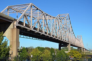
The Martin Luther King Bridge in St. Louis, Missouri, is a cantilever truss bridge of about 4,000 feet (1,200 m) in total length across the Mississippi River, connecting St. Louis with East St. Louis, Illinois. Opened in 1951, the bridge serves as traffic relief connecting the concurrent freeways of Interstate 55, Interstate 64, and U.S. Route 40 with the downtown streets of St. Louis. It was renamed for King in 1968 after the national civil rights leader was assassinated that year.

Forgottonia, also spelled Forgotonia, is the name given to a 16-county region in Western Illinois in the late 1960s and early 1970s. This geographic region forms the distinctive western bulge of Illinois that is roughly equivalent to "The Tract", the Illinois portion of the Military Tract of 1812, along and west of the Fourth Principal Meridian. Since this wedge-shaped region lies between the Illinois and Mississippi rivers, it has historically been isolated from the eastern portion of Central Illinois.

U.S. Highway 20 (US 20) in Iowa is a major east–west artery which runs across the state, separating the northern third of Iowa from the southern two-thirds. It enters Iowa from Nebraska, concurrent with Interstate 129 (I-129) and US 75, crossing the Missouri River at Sioux City. US 20 runs in a more-or-less straight line across Iowa, paralleling 42° 27' N. It leaves Iowa in Dubuque by crossing the Mississippi River into Illinois. Since October 2018, US 20 is a four-lane divided highway for its entire length in Iowa.

U.S. Route 54 (US 54) in Illinois is a 23.9-mile-long (38.5 km) east–west highway that travels from the Champ Clark Bridge on the Missouri state line to I-72/US 36/IL 107 south of Griggsville. At its greatest extent, US 54 used to continue east to Springfield, then northeast to Onarga, and then north all the way to Downtown Chicago.
In the U.S. state of Illinois, U.S. Route 36 (US 36) is an east–west highway that runs across the central portion of the state. It runs east from Missouri over the Mark Twain Memorial Bridge over the Mississippi River with Interstate 72. The eastern terminus of U.S. 36 in Illinois is located near the unincorporated area of Raven near the Illinois-Indiana state line. This is a distance of 216.47 miles (348.37 km).

State Highway 55 (SH-55) is an Idaho highway from Marsing to New Meadows, connecting with US-95 at both ends.

U.S. Route 36 in the state of Missouri is an expressway with many freeway sections, connecting Kansas to Illinois. From Cameron to the Illinois state line, it forms part of the principal route between Kansas City and Chicago, known as the Chicago–Kansas City Expressway.

Interstate 74 (I-74) is the central freeway through the Iowa Quad Cities. It roughly divides Davenport to the west and Bettendorf to the east. The Interstate Highway begins at an interchange with I-80 at the northeastern edge of Davenport and continues into Illinois at the Mississippi River by crossing the I-74 Bridge. The freeway was built in stages during the late 1960s and early 1970s.
U.S. Highway 61 (US 61) is a United States Highway that serves eastern Iowa. It enters the state from Missouri near Keokuk with US 136. North of Keokuk, it is overlapped by US 218 for a few miles. It the follows the course of the Mississippi River past Montrose and Fort Madison. It meets US 34 at Burlington. It passes through Wapello and bypasses Muscatine and Blue Grass on its way toward Davenport. There, it follows Interstate 280 (I-280) and I-80 around the Quad Cities. North of Davenport, it follows a freeway north toward DeWitt where it meets US 30. The highway continues north through Maquoketa and reaches the Dubuque area. There it is joined by US 151 and briefly by US 52. The two highways enter the downtown area on an expressway. Due to the proximity of the Mississippi River and railroad tracks that lie between, the routes have an indirect junction with US 20. The two highways leave the state and enter Wisconsin about one-half mile (800 m) north of the Illinois–Wisconsin state line.
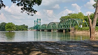
The Florence Bridge is a vertical-lift bridge that carries Illinois Route 100 (IL 100) and IL 106 across the Illinois River from Florence to Scott County, Illinois. The bridge is the middle of the three Illinois River crossings on IL 100, with the other two in Hardin and Beardstown. From its opening in 1929 until 1991, it carried U.S. Route 36 (US 36) and IL 100. In 1991, Interstate 72 (I-72) and the Valley City Eagle Bridges were completed 6 miles (9.7 km) upstream, and US 36 was designated onto I-72, with the old route signed as IL 106. The bridge was rehabilitated in 1981, and again in 2004. The second time, the bridge was closed due to the need to replace the deck. Traffic was detoured to I-72. In 2012, the bridge's lifting mechanism that allows barge traffic to pass under the bridge had serious problems, and continued use could affect the structural integrity of the span. Therefore, the span was raised and the bridge closed for nine months for repairs, using I-72 as a detour. The bridge reopened on April 22, 2013.
U.S. Route 67 (US 67) is a component of the United States Numbered Highway System that connects Presidio, Texas, to Sabula, Iowa. In Illinois, it serves the western region of the state known as Forgottonia, named for the lack of regional transportation and infrastructure projects. The highway begins its path through the state by crossing the Clark Bridge over the Mississippi River from Missouri at Alton and heads northward through Jerseyville and Jacksonville before it crosses the Illinois River at Beardstown. The northern half of the route serves Macomb and Monmouth before it enters the Quad Cities. It leaves the state at Rock Island by crossing the Rock Island Centennial Bridge over the Mississippi River into Davenport, Iowa.


