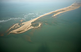
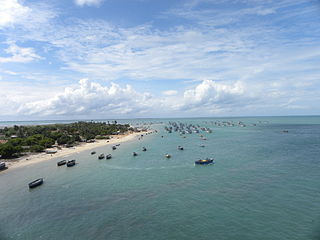
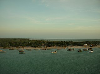
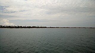
Dhanushkodi is an abandoned town at the south-eastern tip of Pamban Island of the state of Tamil Nadu in India. It is south-east of Pamban and is about 24 kilometres (15 mi) west of Talaimannar in Sri Lanka. The town was destroyed during the 1964 Rameswaram cyclone and remains uninhabited in the aftermath. Today only a few vendors and restaurants can be seen at Dhanushkodi during the day along with the ruins of the long destroyed town.
The Palk Strait is a strait between the Tamil Nadu state of India and the Jaffna District of the Northern Province of the island nation of Sri Lanka. It connects the Bay of Bengal in the northeast with Palk Bay in the southwest. With a maximum depth of less than 9.1 m, it is 40 to 85 miles wide and 85 miles long. Several rivers flow into it, including the Vaigai River of Tamil Nadu. The strait is named after Robert Palk, who was a governor of Madras (1755–1763) during the Company Raj period.
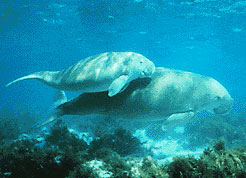
The Gulf of Mannar is a large shallow bay forming part of the Laccadive Sea in the Indian Ocean with an average depth of 5.8 m (19 ft). It lies between the southeastern tip of India and the west coast of Sri Lanka, in the Coromandel Coast region. The chain of low islands and reefs known as Ram Sethu, which includes Mannar Island, separates the Gulf of Mannar from Palk Bay, which lies to the north between India and Sri Lanka. The estuaries of Thamirabarani River and Vaippar River of South India and the Malvathu Oya of Sri Lanka drain into the Gulf. The dugong is found here.

The Laccadive Sea, also known as the Lakshadweep Sea, is a body of water bordering India, the Maldives, and Sri Lanka. It is located to the southwest of Karnataka, to the west of Kerala and to the south of Tamil Nadu. This warm sea has a stable water temperature through the year and is rich in marine life, the Gulf of Mannar alone hosting about 3,600 species. Mangaluru, Kasaragod, Kannur, Kozhikode, Ponnani, Kochi, Alappuzha, Kollam, Thiruvananthapuram, Tuticorin, Colombo, and Malé are the major cities on the shore of the Laccadive Sea. Kanyakumari, the southernmost tip of peninsular India, also borders this sea.

Palk Bay is a semi-enclosed shallow water body between the southeast coast of India and Sri Lanka, with a water depth maximum of 13 m. Palk Bay is located between 8° 50′ and 10° North latitudes and 78° 50′ and 80° 30′ East longitudes. The width of Palk Bay ranges from 57 to 107 km and the length is around 150 km. It is one of the major sinks for sediments along with the Gulf of Mannar. Sediments discharged by rivers and transported by the surf currents as littoral drift settle in this sink. Few scientists have tried to understand the wave characteristics within the Palk Bay.
Kilakarai is a municipality in Ramanathapuram district in the Indian state of Tamil Nadu. As of 2011, the town had a population of 38,355. Kilakarai is one of the Taluka in Ramanathapuram District.
The Gulf of Mannar Marine National Park is a protected area of India consisting of 21 small islands (islets) and adjacent coral reefs in the Gulf of Mannar in the Indian Ocean. It lies 1 to 10 km away from the east coast of Tamil Nadu, India for 160 km between Thoothukudi (Tuticorin) and Dhanushkodi. It is the core area of the Gulf of Mannar Biosphere Reserve which includes a 10 km buffer zone around the park, including the populated coastal area. The park has a high diversity of plants and animals in its marine, intertidal and near shore habitats. Public access inside the park is limited to glass-bottom boat rides. It was established as a National Park in 1986.
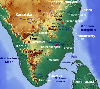
Ramanathapuram District, also known as Ramnad District, is one of the 38 districts an administrative districts of Tamil Nadu state in southern India. The old Ramanathapuram District consists of Present day Virudhunagar and Sivagangai districts, it touches the Western ghats and bordered with the state of Kerala and east by Bay of Bengal. It was the largest district on that time. The town of Ramanathapuram is the district headquarters. Ramanthapuram District has an area of 4,123 km2. It is bounded on the north by Sivaganga District, on the northeast by Pudukkottai District, on the east by the Palk Strait, on the south by the Gulf of Mannar, on the west by Thoothukudi District, and on the northwest by Virudhunagar District. The district contains the Pamban Bridge, an east–west chain of low islands and shallow reefs that extend between India and the island nation of Sri Lanka, and separate the Palk Strait from the Gulf of Mannar. The Palk Strait is navigable only by shallow-draft vessels. As of 2011, Ramanathapuram district had a population of 1,353,445 with a sex-ratio of 983 females for every 1,000 males. The district is home to the pilgrimage center of Rameswaram.

Marine National Park in the Gulf of Kutch is situated on the southern shore of the Gulf of Kutch in the Devbhumi Dwarka district of Gujarat state, India. In 1980, an area of 270 km2 from Okha to Jodiya was declared Marine Sanctuary. Later, in 1982, a core area of 110 km2 was declared Marine National Park under the provisions of the Wildlife (protection) Act, 1972 of India. There are 42 islands on the Jamnagar coast in the Marine National Park, most of them surrounded by reefs. The best-known island is Pirotan. It is located just adjacent to Indianoil COT at Vadinar. Many people working at Indianoil are certified guide at the park.
Mannar may refer to the following places:
Pamban Island, also known as Rameswaram Island, is an island located between peninsular India and Sri Lanka, on the Rama Setu archipelago. The second largest island in the latter, Pamban Island belongs to India and forms the Rameswaram taluk of the Ramanathapuram district of the state of Tamil Nadu. It is the largest island in Tamil Nadu by area. The principal town in the island is the pilgrimage centre of Rameswaram.

Mannar District is one of the 25 districts of Sri Lanka, the second level administrative division of the country. The district is administered by a District Secretariat headed by a District Secretary appointed by the central government of Sri Lanka. The capital of the district is Mannar, which is located on Mannar Island.
Nalla Thanni Theevu is an island situated in the Gulf of Mannar about 4 kilometers south-east of the coast of Tamil Nadu, India. It is one of the three uninhabited islands in the Gulf of Mannar the others being Krusadai Island and Muyal Island. It forms a part of the Kadaladi taluk of Ramanathapuram district.
Vedalai is a village in Ramanathapuram district, Tamil Nadu state in southern India.
Devipattinam is a coastal village of Ramanathapuram district, Tamil Nadu, India.

Coral reefs in India are one of the most ancient and dynamic ecosystems of India. The coral reefs not only provide a sanctuary to a myriad of marine life but also play a key role in protecting the coastline from erosion. India has about 7517 km of coastline including islands but mainland coast is 6100 km.
Krusadai Island is an uninhabited island in the Gulf of Mannar situated south of Pamban Island. The island belongs to India and forms a part of the Gulf of Mannar Marine National Park.
Pullivasal Island is an uninhabited island in the Gulf of Mannar situated south of Pamban Island. The island belongs to India and forms a part of the Gulf of Mannar Marine National Park. The area of sea grass beds along the coast is 5.89 square kilometres.
The coastline of Tamil Nadu is located on the southeast coast of Indian Peninsula, and forms a part of Coromandel Coast of Bay of Bengal and Indian Ocean. It is 1076 km long and is the second longest coastline in the country after Gujarat. Chennai, the capital of the state and an important commercial and industrial center in the country is located in the northern part of the coast with Kanniyakumari, forming the southern tip where Indian Ocean, Bay of Bengal and Arabian Sea meet. It also shares maritime border with Sri Lanka across the Palk strait in Gulf of Mannar. The coastal corridor consists of 14 districts with 15 major ports and harbors, sandy beaches, lakes and river estuaries. Tamil Nadu is the only state in India with territory on both the eastern and western coastlines.