Harenna Forest

Last updated
Harenna Forest with Bale Mountains behind. Harenna Forest and Bale Mountains.jpg
Harenna Forest with Bale Mountains behind.

The Harenna Forest is a montane tropical evergreen forest in Ethiopia's Bale Mountains. The forest covers the southern slope of the mountains, extending from 1450 to 3200 meters elevation. The Bale Mountains are in Ethiopia's Oromia Region, and form the southwestern portion of the Ethiopian Highlands. [1]

Contents

It is one of the few remaining natural forests in the country, and the largest. The Harenna Forest is known for its native plants, mammals, amphibians and birds, including many endemic species. [2] The montane climate of the southern Bale Mountains sustains plant communities distinct from those of the adjacent lowlands, and from montane forests elsewhere in the Ethiopian Highlands. [1]

Geography

The Harenna Forest extends across the southern slope of the Bale Mountains. The forest covers portions of Goba, Delo Menna, Harena Buluk, and Meda Welabu woredas (districts) of Bale Zone, and Adaba woreda of West Arsi Zone in Oromia Region. [3] The highest portion of the mountains, known as the Sanetti Plateau, extends above 4000 meters elevation. The southern edge of the plateau drops in a steep escarpment, descending from 3800 to 2800 meters elevation. Below the escarpment the mountain slopes descend more gradually to the southern plains. [1]

The forest is in the upper watershed of the Ganale River, and is drained by its tributaries the Welmel, Weyib, and Dumale rivers.

The forests cover an area of 3500 to 7000 km2, [1] between 39º15' to 40º 15' E Longitude and 6º 0' and 6º 45' N Latitude. The southern portion of Bale Mountains National Park protects part of the forest, which also extends outside the park boundary. [4]

Climate

The forest has a montane tropical climate. There is a rainy season from March to October, and a dry season from November to March. The slopes between 2300 and 3000 meters elevation are often covered in dense mist, particularly during the wet season. [1]

Flora

Plant communities in the forest vary with elevation.

Submontane forests occur from 1450 to 1900 meters elevation. Rainfall is from 500 to 600 mm annually, with a distinct dry season. The predominant tree is the conifer Afrocarpus falcatus . Other canopy trees include Cassipourea malosana, Celtis africana , and Croton macrostachyus . Some trees are semi-deciduous, dropping leaves during the dry season. Wild coffee is a common shrub in the forest understory. [1]

Lower montane forests grow between 1900 and 2300 meters elevation. Middle montane forests occur between 2300 and 2800 meters. Upper montane forests, which include forests dominated by Hagenia abyssinica and extensive stands of the bamboo Yushania alpina , grow from 2800 to 3250 meters elevation. [1]

Subalpine heathland, dominated by the tree heath Erica arborea , extends from 3250 to 3500 meters elevation, and forms the transition between the forest and the high-elevation alpine moorlands of the Sanetti Plateau. [1]

The tree Gymnosporia harenensis is endemic to the forest, and is also classified by the IUCN as vulnerable due to the threat of logging. [5]

Fauna

Giant forest hogs in the Harenna Forest, Bale Mountains NP, Ethiopia Hylochoerus meinertzhageni Harenna forest.jpg
Giant forest hogs in the Harenna Forest, Bale Mountains NP, Ethiopia

The Harenna Forest was once habitat to packs of the endangered painted hunting dog, Lycaon pictus. However, the presence of this canid is now in question here due to the population pressures of expanding human presence. [6] The subalpine heathlands and alpine moorlands of the Sanetti Plateau are home to the largest population of the rare and endangered Ethiopian wolf.

The Bale Mountains vervet (Chlorocebus djamdjamensis) is limited to the upper Harenna Forest and other nearby forests. Its diet consists mostly of Yushania alpina bamboo shoots. [7] The Harenna shrew (Crocidura harenna) is endemic to the forest, and the Bale shrew (Crocidura bottegoides) is found only in the forest and the afroalpine grasslands of the Sanetti Plateau. [8]

The Harenna Forest is home to Ethiopia's only population of Harvey's duiker (Cephalophus harveyi). [8]

Conservation

Forest lands in Ethiopia, including the Harenna Forest, are government-owned. Bale Mountains National Park covers the central part of the forest. The portion of the forest outside the national park is managed by Oromia Forest and Wildlife Enterprise (OFWE), a branch of the Oromia Region government. OFWE organized forest management in the region into eight local units, and Harenna Forest has been managed by Bale Forest Enterprise since 2009. Forests are managed in partnership with local communities. [3]

Historically the forest was thinly populated. Many people have migrated to and settled in Harenna Forest in recent decades. The greatest population growth was in the late 1990s and early 2000s, when the population of Harena Buluk and Delo Menna woredas doubled. Population growth then slowed in the 2010s. New residents cleared areas of forest for coffee cultivation, pasture, and subsistence farming, mostly in Harena Buluk woreda. [3] Comparison of Landsat satellite images from 1986 and 2006 found a reduction in forest area, particularly in the high-elevation ericaceous belt, with most of the former forest area converted to grassland and pasture by regular burning. Agricultural land is concentrated at lower elevations, along the forest–savanna transition. [9]

The Ethiopian government has designated several areas of the forest as national forest priority areas, including Mena-Angetu National Forest Priority Area, which wraps around Bale National Park on the southeast, south, and southwest, and Harena-Kokosa National Forest Priority Area, west of Bale National Park and north of Mena-Angetu. [3]

See also

Related Research Articles

<span class="mw-page-title-main">Bale Mountains</span> Mountain ranges in southeastern Ethiopia

The Bale Mountains are mountain ranges in the Oromia Region of southeast Ethiopia, south of the Awash River, part of the Ethiopian Highlands. They include Tullu Demtu, the second-highest mountain in Ethiopia, and Mount Batu. The Weyib River, a tributary of the Jubba River, rises in these mountains east of Goba. The Bale Mountains National Park covers 2,200 square kilometers of these mountains. The park's main attractions are the wild alpine scenery and the relative ease with which visitors can see unique birds and mammals.

<span class="mw-page-title-main">Bale Mountains National Park</span> National park in Oromia Region, Ethiopia

Bale Mountains National Park (BMNP) is a national park in Ethiopia. The park encompasses an area of approximately 2,150 km2 (830 sq mi) in the Bale Mountains and Sanetti Plateau of the Ethiopian Highlands.

<span class="mw-page-title-main">Ethiopian Highlands</span> Mountain range in northern Ethiopia

The Ethiopian Highlands is a rugged mass of mountains in Ethiopia in Northeast Africa. It forms the largest continuous area of its elevation in the continent, with little of its surface falling below 1,500 m (4,900 ft), while the summits reach heights of up to 4,550 m (14,930 ft). It is sometimes called the "Roof of Northeastern Africa" due to its height and large area. It is the only country in the region with such a high elevated surface. This elevated surface is bisected diagonally by the Great East African Rift System which extends from Syria to Mozambique across the East African Lakes. Most of the Ethiopian Highlands are part of central and northern Ethiopia, and its northernmost portion reaches into Eritrea.

<span class="mw-page-title-main">Afromontane</span> Subregion of the Afrotropical realm

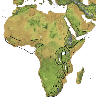
The Afromontane regions are subregions of the Afrotropical realm, one of the Earth's eight biogeographic realms, covering the plant and animal species found in the mountains of Africa and the southern Arabian Peninsula. The Afromontane regions of Africa are discontinuous, separated from each other by lower-lying areas, and are sometimes referred to as the Afromontane archipelago, as their distribution is analogous to a series of sky islands.

Walmara is a district in the Oromia Special Zone Surrounding Finfinne, Oromia Region, Ethiopia. It is bordered on the south by the Sebeta Hawas, on the west by West Shewa Zone, on the north by Mulo, on the northeast by the Sululta, and on the east by the city of Addis Ababa. Towns in Walmara include Kolobo and Holeta.

<span class="mw-page-title-main">Sululta</span> Town in Oromia Region, Ethiopia

Sululta is a town and woreda in Oromia Region, Ethiopia. It was part of former Mulona Sululta woreda which was separated for Mulo and Sululta woredas. Part of the Oromia Special Zone Surrounding Finfinne, Sululta is bordered on the south by the city of Addis Ababa, on the west by the Mulo and West Shewa Zone, on the north by North Shewa Zone, and on the east by Bereh. Towns in Sululta include Chancho, Durba, Muger Sheleko, Rob Gebeya, Sululta and Segno Gebeya.

<span class="mw-page-title-main">Southwestern Arabian montane woodlands</span>

The Southwestern Arabian montane woodlands is a xeric woodland ecoregion in the southwestern Arabian Peninsula.

Dinsho is one of the districts in the Oromia Region of Ethiopia. It was part of former Sinanana Dinsho woreda what was separated for Dinsho and Sinana woredas and Robe Town. Part of the Bale Zone, Sinanana Dinsho was bordered on the south by the Mena River which separated it from Goba, on the west by Adaba, on the northwest by Agarfa, on the northeast by Gaserana Gololcha, on the east by Ginir, and on the southeast by Goro, Oromia. The administrative center of this woreda is Dinsho.

Goba is a woreda in the Oromia Region, Ethiopia. It is named after the town of Goba. Part of the Bale Zone, Goba is bordered on the south by Mennana Harena Buluk, on the west by Mirab Arsi Zone, on the north by the Mena River which separates it from Sinanana Dinsho, and on the southeast by Berbere.

Delo Menna is one of the woredas in the Oromia Region of Ethiopia. It was part of former Menna Angetu woreda what was separated into Delo Menna and Harena Buluk woredas, and it's part of the Bale Zone. Delo Menna is bordered on the south by Meda Welabu, on the west and northwest by Harena Buluk, on the north by Goba, on the northeast by Berbere, and on the east by Guradamole. The administrative center of this woreda is Menna

Meda Welabu is a woreda in Oromia Region, Ethiopia. Part of the Bale Zone, Meda Welabu is bordered on the south by the Ganale Dorya River which separates it from the Guji Zone, on the northwest by West Arsi Zone, on the north by Mennana Harena Buluk, and on the northeast by Guradamole. The administrative center of the woreda is Bidire; other towns in Meda Welabu include Oborso.

Berbere is a woreda in Oromia Region, Ethiopia. Part of the Bale Zone, Berbere is bordered on the south by Mennana Harena Buluk, on the northwest by Goba, on the north by Sinanana Dinsho, on the northeast by Goro, and on the east by Guradamole; the Mena River separates it from Shinanana Dinsho and Goro. The administrative center of the woreda is Haro Dumal.

Seweyna is one of the woredas in the Oromia Region of Ethiopia. Located in the eastern part of the Bale Zone, Seweyna is bordered on the south by Raytu, on the southwest by Ginir, on the northwest by Gaserana Gololcha, on the north by Legehida, and on the east by the Somali Region. Towns in Seweyna include Hada.

<span class="mw-page-title-main">Bale Mountains vervet</span> Species of Old World monkey

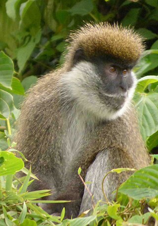
The Bale Mountains vervet is a terrestrial Old World monkey endemic to Ethiopia, found in the bamboo forests of the Bale Mountains. All species in Chlorocebus were formerly in the genus Cercopithecus. The Bale Mountains vervet is one of the least-known primates in Africa. They avoid tree-dominated and bushland areas as their habitat. These monkeys mainly reside in the bamboo forest of the Bale Mountains due their dietary specialization on bamboo, but other factors, such as climate, forest history, soil quality, and disease, are likely to play a role in their choice to inhabit this area. The Bale Mountains vervet have a very quiet behavior and tend to flee when encountering a human being. It is also known as the Bale monkey.

<span class="mw-page-title-main">Sanetti Plateau</span> High plateau in Ethiopia.

The Sanetti Plateau is a major plateau of the Ethiopian Highlands, in the Oromia Region of Ethiopia. The plateau is the highest part of the Bale Mountains, and is located within Bale Mountains National Park.

<span class="mw-page-title-main">Ethiopian montane grasslands and woodlands</span>

The Ethiopian montane grasslands and woodlands is a montane grasslands and shrublands ecoregion in Ethiopia. It occupies the middle elevations of the Ethiopian Highlands, between the high-altitude Ethiopian montane moorlands and the lower-elevation Ethiopian montane forests.

<span class="mw-page-title-main">Ethiopian montane moorlands</span>

The Ethiopian montane moorlands is a montane grasslands and shrublands ecoregion in Ethiopia. It lies above 3,000 meters elevation in the Ethiopian Highlands, the largest Afroalpine region in Africa. The montane moorlands lie above the tree line, and consist of grassland and moorland with abundant herbs and shrubs adapted to the high elevation conditions.

Harena Buluk is one of the woredas in the Oromia Region of Ethiopia. It was part of former Menna Angetu woreda. It is part of the Bale Zone. Harena Buluk woreda is bordered on the south by Meda Welabu, on the north by Goba, on the west by Nensebo, on the northwest by Adaba, and on the east by [[Delo Menna, Oromia (woreda). The administrative center for the woreda is Angetu.

<span class="mw-page-title-main">Ethiopian montane forests</span> Tropical moist broadleaf forest ecoregion in Ethiopia

The Ethiopian montane forests is a tropical moist broadleaf forest ecoregion in eastern Africa. It covers the middle elevations of the Ethiopian Highlands in Ethiopia and extends into neighboring Eritrea, Sudan, Djibouti, and Somaliland. The ecoregion includes distinctive Afromontane forests, woodlands, grasslands, and shrublands. The ecoregion's biodiversity is threatened by deforestation, conversion to agriculture, and overgrazing.

Arsi Mountains National Park is a national park in Arsi Zone of Oromia Region in Ethiopia. It protects a portion of the Ethiopian Highlands, and includes montane forests, subalpine heath, and alpine grasslands and shrublands. The park was designated in 2011, and covers an area of 10876 km2.

References

  1. 1 2 3 4 5 6 7 8 Bussmann, Rainer. (1997). The forest vegetation of Harenna escarpment (Bale Province, Ethiopia) - syntxomomy and phytogeographical affinities. Phytocoenologia. 27. 1-23.
  2. L.J.G. van der Maesen, X.M. van der Burgt and J.M. van Medenbach de Rooy. 1994. The Biodiversity of African Plants: Proceedings, XIVth AETFAT Congress, 22–27 August 1994, Wageningen, The Netherlands, Published by Springer, ISBN   978-0-7923-4095-9. 861 pages.
  3. 1 2 3 4 Dereje Tadesse Wakjira, Floris D’Udine, and Alec Crawford (2015) "Migration and Conservation in the Bale Mountains Ecosystem". International Institute for Sustainable Development, August 2015.
  4. Alemu, Misrak & Suryabhagavan, Karuturi & Balakrishnan, M. (2012). Assessment of Cover Change in the Harenna Habitats in Bale Mountains, Ethiopia Using GIS and Remote Sensing. International Journal of Ecology and Environmental Sciences. 38. 39-45.
  5. World Conservation Monitoring Centre 1998. Maytenus harenensis. The IUCN Red List of Threatened Species. Version 2014.3. <www.iucnredlist.org>. Downloaded on 11 May 2015.
  6. C. Michael Hogan. 2009. Painted Hunting Dog: Lycaon pictus, GlobalTwitcher.com, ed. N. Stromberg Archived 2010-12-09 at the Wayback Machine
  7. Mekonnen, A., Fashing, P.J., Bekele, A. et al. Dietary flexibility of Bale monkeys (Chlorocebus djamdjamensis) in southern Ethiopia: effects of habitat degradation and life in fragments. BMC Ecol 18, 4 (2018). https://doi.org/10.1186/s12898-018-0161-4
  8. 1 2 Lavrenchenko, Leonid. (2000). The mammals of the isolated Harenna Forest (southern Ethiopia): Structure and history of the fauna. Bonner Zoologische Monographien. 46. 223-231.
  9. Alemu, Misrak & Suryabhagavan, Karuturi & Balakrishnan, M.. (2012). Assessment of Cover Change in the Harenna Habitats in Bale Mountains, Ethiopia Using GIS and Remote Sensing. International Journal of Ecology and Environmental Sciences. 38. 39-45.

6°30′48″N39°14′50″E / 6.513452°N 39.247164°E / 6.513452; 39.247164