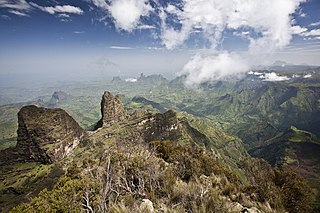

The Sanetti Plateau is a major plateau of the Ethiopian Highlands, in the Oromia Region of Ethiopia. The plateau is the highest part of the Bale Mountains, and is located within Bale Mountains National Park. [1]


The Sanetti Plateau is a major plateau of the Ethiopian Highlands, in the Oromia Region of Ethiopia. The plateau is the highest part of the Bale Mountains, and is located within Bale Mountains National Park. [1]
The plateau exceeds 4000 meters in elevation, and its highest point is Mount Tullu Dimtu at 4,377 metres (14,360 ft). The southern edge of the plateau forms a steep escarpment, known as the Harenna escarpment, which descends from 3800 to 2800 meters elevation.
The northern slopes drain into the Shebelle River, and the southern slopes are drained by tributaries of the Ganale River, including the Weyib. The southern slopes receive higher rainfall, generally 1000 mm or more annually, while the northern slopes are in the drier rain shadow of the mountains.
The highest portion of the plateau, from approximately 3800 to 4377 meters, is covered by Afroalpine vegetation, including Helichrysum shrublands, tussock grasslands with Festuca abyssinica predominant, and groves of the giant lobelia Lobelia rhynchopetalum . A belt of low ericaceous subalpine forest lies below the alpine zone, between 3800 and 3250 meters elevation, and extending up to 4000 meters in sheltered stream valleys. Erica arborea and Erica trimera are the characteristic plants, growing as shrubs or small trees. These alpine and subalpine plant communities are part of the Ethiopian montane moorlands ecoregion, and the plateau is the largest Afroalpine area in the Ethiopian Highlands. [2]
The Harenna Forest covers the southern slope of the Bale Mountains, below 3250 meters elevation. The upper elevations of the forest include extensive groves of bamboo ( Yushania alpina ) and cloud forest dominated by Hagenia abyssinica . The drier northern slopes include some remnant woodlands of Hagenia abyssinica, African juniper (Juniperus procera), and Hypericum revolutum below 3400 meters elevation. Much of the north slope's original dry woodland has been cleared for agriculture and pasture. [2]
This region is known for its mammals, amphibians and birds including many endemic species. The plateau's afroalpine grasslands and shrublands are home to the largest population of the endangered Ethiopian wolf (Canis simensis). The endangered mountain nyala (Tragelaphus buxtoni) is found in the subalpine and upper montane woodlands. The Bale shrew (Crocidura bottegoides) is found only in the afroalpine grasslands of the plateau and clearings in the adjacent high-mountain forests. [3]
The Sanetti Plateau once was habitat to packs of the endangered painted hunting dog, (Lycaon pictus) but the presence of this canid is now in question here due to the population pressures of expanding human presence. [4]

The Eastern Highlands, also known as the Manica Highlands, is a mountain range on the border of Zimbabwe and Mozambique. The Eastern Highlands extend north and south for about 300 kilometres (190 mi) through Zimbabwe's Manicaland Province and Mozambique's Manica Province.

Simien Mountains National Park is the largest national park in Ethiopia. Located in the North Gondar Zone of the Amhara Region, its territory covers the highest parts of the Simien Mountains and includes Ras Dashan, the highest point in Ethiopia.

The Bale Mountains are mountain ranges in the Oromia Region of southeast Ethiopia, south of the Awash River, part of the Ethiopian Highlands. They include Tullu Demtu, the second-highest mountain in Ethiopia, and Mount Batu. The Weyib River, a tributary of the Jubba River, rises in these mountains east of Goba. The Bale Mountains National Park covers 2,200 square kilometers of these mountains. The park's main attractions are the wild alpine scenery and the relative ease with which visitors can see unique birds and mammals.

Bale Mountains National Park (BMNP) is a national park in Ethiopia. The park encompasses an area of approximately 2,150 km2 (830 sq mi) in the Bale Mountains and Sanetti Plateau of the Ethiopian Highlands.

The Ethiopian Highlands is a rugged mass of mountains in Ethiopia in Northeast Africa. It forms the largest continuous area of its elevation in the continent, with little of its surface falling below 1,500 m (4,900 ft), while the summits reach heights of up to 4,550 m (14,930 ft). It is sometimes called the "Roof of Africa" due to its height and large area. It is the only country in the region with such a high elevated surface. This elevated surface is bisected diagonally by the Great East African Rift System which extends from Syria to Mozambique across the East African Lakes. Most of the Ethiopian Highlands are part of central and northern Ethiopia, and its northernmost portion reaches into Eritrea.

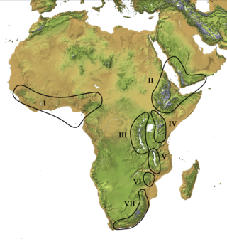
The Afromontane regions are subregions of the Afrotropical realm, one of the Earth's eight biogeographic realms, covering the plant and animal species found in the mountains of Africa and the southern Arabian Peninsula. The Afromontane regions of Africa are discontinuous, separated from each other by lower-lying areas, and are sometimes referred to as the Afromontane archipelago, as their distribution is analogous to a series of sky islands.

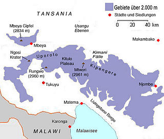
Mount Rungwe is a volcanic mountain in Mbeya Region, in Tanzania's Southern Highlands. At an altitude of 2,981 metres (9,780 ft), it is southern Tanzania's second-highest peak. Rungwe's volcano is currently inactive.

The Cameroonian Highlands forests, also known as the Cameroon Highlands forests, are a montane tropical moist broadleaf forest ecoregion located on the range of mountains that runs inland from the Gulf of Guinea and forms the border between Cameroon and Nigeria. This is an area of forest and grassland which has become more populous as land is cleared for agriculture.
Dendrosenecio meruensis is one of the East African giant groundsel, this one is endemic to the slopes of Mount Meru. Once they were considered to be of the genus Senecio but since then have been reclassified into their own genus Dendrosenecio.

The Harenna Forest is a montane tropical evergreen forest in Ethiopia's Bale Mountains. The forest covers the southern slope of the mountains, extending from 1450 to 3200 meters elevation. The Bale Mountains are in Ethiopia's Oromia Region, and form the southwestern portion of the Ethiopian Highlands.
The Ethiopian montane grasslands and woodlands is a montane grasslands and shrublands ecoregion in Ethiopia. It occupies the middle elevations of the Ethiopian Highlands, between the high-elevation Ethiopian montane moorlands and lowland woodlands, savannas, shrublands, and thickets.

The Ethiopian montane moorlands is a montane grasslands and shrublands ecoregion in Ethiopia. It lies above 3,000 meters elevation in the Ethiopian Highlands, the largest Afroalpine region in Africa. The montane moorlands lie above the tree line, and consist of grassland and moorland with abundant herbs and shrubs adapted to the high elevation conditions.

The East African montane moorlands is a montane grasslands and shrublands ecoregion which occupies several high mountain peaks in Kenya, South Sudan, Tanzania, and Uganda.
Harena Buluk is one of the woredas in the Oromia Region of Ethiopia. It was part of former Menna Angetu woreda. It is part of the Bale Zone. Harena Buluk woreda is bordered on the south by Meda Welabu, on the north by Goba, on the west by Nensebo, on the northwest by Adaba, and on the east by [[Delo Menna, Oromia (woreda). The administrative center for the woreda is Angetu.

The Ruwenzori-Virunga montane moorlands is a montane grasslands and shrublands ecoregion of the Rwenzori Mountains and Virunga Mountains in central Africa.

The Ethiopian montane forests is a tropical moist broadleaf forest ecoregion in Ethiopia. It covers the southwestern and southeastern portions of the Ethiopian Highlands. The ecoregion includes distinctive Afromontane evergreen forests. The ecoregion's biodiversity is threatened by deforestation, conversion to agriculture, and overgrazing.
The Ukaguru Mountains are a mountain range in central Tanzania. The mountains are in Morogoro region, east of Tanzania's capital Dodoma. The mountains are named for the Kaguru people. The Ukaguru Mountains are part of the Eastern Arc Mountains, and are home to a biodiverse community of flora and fauna with large numbers of endemic species.

The Somali Acacia–Commiphora bushlands and thickets is a semi-arid tropical grasslands, savannas, and shrublands ecoregion in the Horn of Africa. It is home to diverse communities of plants and animals, including several endemic species.

The Southwestern Arabian foothills savanna, also known as the Southwestern Arabian Escarpment shrublands and woodlands, is a desert and xeric shrubland ecoregion of the southern Arabian Peninsula, covering portions of Saudi Arabia, Yemen, and Oman.
Arsi Mountains National Park is a national park in Arsi Zone of Oromia Region in Ethiopia. It protects a portion of the Ethiopian Highlands, and includes montane forests, subalpine heath, and alpine grasslands and shrublands. The park was designated in 2011, and covers an area of 10876 km2.