Harir Mountain

Last updated
Harir Mountain
Highest point
Elevation 7,800 ft (2,400 m)
Coordinates 13°44′41″N44°51′52″E / 13.74472°N 44.86444°E / 13.74472; 44.86444
Geography
Location Dhale Flag of Yemen.svg  Yemen

Harir Mountain is located in Yemen, and is one of the largest mountains in Dhale Governorate. The name of Harir Mountain is mentioned in Al-Hamdani's "Description of the Arabian Peninsula" book. [1] Also in "The History of Yemeni Tribes" by Hamza Ali Luqman. [2] Also mentioned by many Yemeni and Arab historians and writers, as well as in history and geography school textbooks. Harir Mountain is located in the east of Dhale governorate and within the administrative division of Al Hussein District. It's 20 kilometers from Dhale, and it is a mountain range that extends from Naqil (Al-Maadi) to the south, until Zahert Al-Atry to the north. Small mountains, rocky outcrops, valleys, and reefs branch off from it, as well as deep abysses to the west and east. The mountain range ends at Al-Hamayer and Al-Hasswa and Seelat Ghafinah in Shaka Valley near Aqram Mountain and at Lakmat El-Nub, Seelat Hamam, and EL-Haza to the west. [3] And the village of Adina Wahid Ali which overlooks Murat Valley and Adina to the east. Harir Mountain is bordered from the south and east by Halimayn District. And from the north is the Shuaib district, and to the west is Shaka, Khella, Al-Hussein, and Al-Sha'ari land. Its altitude is 7800 feet above sea level. At the top of the mountain, there is a flat area on which villages have been built and residences have been constructed, interspersed with valleys and green agricultural terraces. [4]

Contents

Al-Fuqaha Village

At the highest peak of Harir Mountain is the Al-Fuqaha, considered one of the largest and oldest villages on the mountain, as well as the main center of the mountain. Its buildings were constructed from hard stones. It was named after Fiqh because there were judges and legal document writers who graduated at the hands of scholars from Jableh who wrote and notarized between people.[ citation needed ] Al-Hota is an extension of the Al-Fuqaha Village, where there are some shops, where agricultural products are traded, a health center, and a high school built in 2000. At the southern end of Harir Mountain are the villages of Al-Marafda, Al-Hardud, Hegla, Al-Jous, Al-Mihra, and Al-Masnaa. Not far from these villages, in a central location to the villages of Mountain Harir, there is a unified school for boys and girls built in 1950, it is the first school built in Harir by the British known as "School". [5]

Northern end

The northern end of Harir Mountain includes the village of Adina, which is known for its cultivation of coffee and grains and its abundance of water. Arashi Village is an agricultural village with an abundance of water as well. Zahera Village which is known for its coffee cultivation. Marrat Village is known for its wide range of land and surface wells. These villages are located on the top of Harir Mountain from south to north, while the villages related to the mountain from east to west include the villages of Ghasha, Husn al-Badawi, Asiqa, Mashirah, and Mthaad. The villages from the west include Al-Maariyad, Al-Qabal, Azan, Laklamt al-Nowab, Al-Qarmah, and Ataba. The Aden port, airport, and free zone can be seen from the south side. Also from the east side, the Yafe Mountains and the Halimayn Mountains. Also, Al-Awabel Mountain and Meris Mountain, which is adjacent to Harir Mountain from the north and Jahaf Mountain from the west can be seen. The mountain is believed to be the original home of the Hariri family. As Muhammad Abdul Qadir Bamatraf points out in his book “Al-Jami’: Notable Emigrants Affiliated to Yemen and Their Tribes”: The Hariri is a tribe of the Azdi tribe, one of the largest Hauran clans, one of the governorates of the Syrian Republic, owns 18 villages, and had moved from Basra except for a group that remained there. [6]

Origin of the name

Harir Mountain is the original home of the Hariris which their historical origin goes back to Harir ibn al-Harith ibn Zayd ibn Yarim ibn Dhu-Ra'een, with their descendants, including Shams al-Din and the Fakhreddin families. Some of them lived in this mountain, some of them migrated to other places, and some of them settled in Aden and are called "Al-Hariri". Harir Mountain has many historical landmarks and monuments, indicating that ancient man inhabited the peaks of the mountain. There are some ancient inscriptions and writings on Rumah and Attaba. [7] In boulders, some old rocks, and dams carved into the mountain, as well as cemeteries, and some old fortresses, which are believed to be related to the ruins of Aqram Mountain in Shekaa.

See also

Related Research Articles

<span class="mw-page-title-main">Lahij Governorate</span> Governorate of Yemen

Lahij is a governorate of Yemen.

<span class="mw-page-title-main">Hajjah</span> City in Yemen

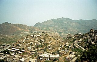
Hajjah is the capital city of Hajjah Governorate in north-western Yemen. It is located 127 kilometres northwest of Sana'a, at an elevation of about 1800 metres. As of 2003, the Hajjah City District had a population of 53,887 inhabitants.

<span class="mw-page-title-main">Harir, Iraq</span> Town in Kurdistan Region, Iraq

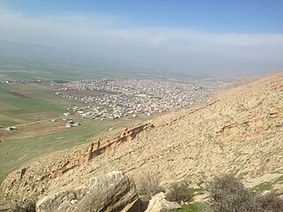
Harir is a town and sub-district in Erbil Governorate in Kurdistan Region, Iraq. The town is located in the Shaqlawa District.

<span class="mw-page-title-main">Hashid</span> Yemeni tribal confederation

The Hashid is a tribal confederation in Yemen. It is the second or third largest – after Bakil and, depending on sources, Madh'hij – yet generally recognized as the strongest and most influential. According to medieval Yemeni genealogies, Hashid and Bakil were the sons of Jashim bin Jubran bin Nawf Bin Tuba'a bin Zayd bin Amr bin Hamdan. Member tribes of the Hashid Confederation are found primarily in the mountains in the North and Northwest of the country.

<span class="mw-page-title-main">Mehri people</span> Ethnic Group

The Mehri, also known as the al-Mahrah tribe, are an Arabian ethnic group primarily inhabiting South Arabia especially in the Al-Mahra Governorate in Yemen and the island of Socotra in the Guardafui Channel. They are named after Mahra bin Haydan. They can also be found in the Sultanate of Oman, and the eastern region of the Arabian Peninsula.

<span class="mw-page-title-main">Banu Hamdan</span> Yemeni tribal group

Banu Hamdan is an ancient, large, and prominent Arab tribe in northern Yemen.

ʽAsr, or Qaryat ʽAsr, also transliterated as ʽAsir, is a western suburb of Sanaa, Yemen, located in Main District of Amanat al-Asimah Governorate. It is located just north of the road to al-Hudaydah, at the western edge of the Sanaa plain. The name ʽAsr is also used for the small wadi by the town, as well as the mountain nearby.

ʽAttan, also transliterated as ʽIttan and known historically as ʽAḍudān, is a village in Bani Matar District of Sanaa Governorate, Yemen. It is a short distance southwest of Sanaa, with the two being separated by a long, low hill.

Masyab, also Musayyib (مُسَيِّب), is a village in Bani Matar District of Sanaa Governorate, Yemen. It is located on the northeastern side of Jabal An-Nabi Shu'ayb.

Radman is a small village in Al Haymah Ad Dakhiliyah District of Sanaa Governorate, Yemen. It is located on the mountain of the same name, near Jabal An-Nabi Shu'ayb.

<span class="mw-page-title-main">Ash Shu'ayb District</span> District in Dhale, Yemen

Ash Shu'ayb District is a district of the Dhale Governorate, Yemen. As of 2003, the district had a population of 38,261 inhabitants.

<span class="mw-page-title-main">Shaharah</span> Village in Amran, Yemen

Shaharah is a large mountain village and seat of Shaharah District of the 'Amran Governorate, Yemen. The village "lies at 2600 metres and overlooks mountainous bulging swells to the south and shimmering hot plains to the north." It lies on top a sharp mountain of the same name, Jabal Shaharah, which is a spur of Jabal al-Ahnum, with its sides and top under extensive cultivation. The village consists of several old stone houses and a cistern. The area is noted for its limestone arch footbridge, constructed in the 17th century by a local lord to connect two villages across a deep gorge.

Bariq is a tribe from Bareq in south-west Saudi Arabia. It belongs to the ancient Al-Azd tribe which has many clans linked to it. As far as ancestry goes, Aws, Khazraj, Ghassān and Banu Khuza'a, and others all belong to Al-Azd. They were one of the tribes of Arabia during Muhammad's era.

Khamir is a small city in the 'Amran Governorate of Yemen. It is the seat of Khamir District. It is now closely associated with the tribal confederation of Hashid, although it is named after a member of the Bakil tribe and was historically mainly a Bakil town.

Khaywan is an old town and corresponding 'uzlah in Huth District of Amran Governorate, Yemen.

<span class="mw-page-title-main">Wadi Zahr</span>

Wadi Zahr, also spelled Wadi Dahr, is a wadi in Yemen, located just north of Sanaa on the western edge of the Sanaa plain. It is watered by a perennial stream whose source is the large catchment area on the eastern slopes of Jabal An-Nabi Shu'ayb. The wadi proper begins near the village of Suq Bayt Naʽam and then flows eastward for about 7km through a steep-sided gorge before ending on the Sanaa plain. Wadi Zahr has fertile soil and was historically a strategic area with several forts. The main settlement in the area today is Qaryat al-Qabil.

Bayt Zud is a village in Kharif District of 'Amran Governorate, Yemen.


Rada'a is a sub-district located in Radda District, Al Bayda Governorate, Yemen. Rada'a had a population of 54714 according to the 2004 census.

Dhorm Mountain is a mountainous elevation of the Sarawat Mountains located in the Asir region of Saudi Arabia. It is distinguished by its picturesque nature and agricultural terraces. Dhorm Mountain also contains a number of historical monuments, including Mount Luqman, which is situated to the east of the villages of Dhorm, specifically at the summit of Dhorm Mountain.

References

  1. ِAl-Hamdani, Abu Muhammad al-Hasan. صفة جزيرة العرب [Description of the Arabian Peninsula] (in Arabic). p. 78.
  2. Luqman, Hamza. تاريخ القبائل اليمنية [The History of Yemeni Tribes] (in Arabic).
  3. Location of the mountain on the map.
  4. "Harir Mountain, Al Dhale Governorate ... Historical and archaeological landmarks" - Asifa News. May 22, 2023. Archived from the original on 2023-07-01. Accessed on 2024-02-08.
  5. "Dhale Governorate-National Information Center- Yemen Republic".
  6. Abdul Qadir Bamatraf, Muhammad. الجامع: أعلام المهاجرين المنتسبين إلى اليمن وقبائلهم [Al-Jami’: Notable Emigrants Affiliated to Yemen and Their Tribes] (in Arabic). p. 342.
  7. "Harir Mountain, Historical monuments in the original home of Hariri Tribe".