The Elbe is one of the major rivers of Central Europe. It rises in the Giant Mountains of the northern Czech Republic before traversing much of Bohemia, then Germany and flowing into the North Sea at Cuxhaven, 110 kilometres northwest of Hamburg. Its total length is 1,094 km (680 mi).

The IJssel is a Dutch distributary of the river Rhine that flows northward and ultimately discharges into the IJsselmeer, a North Sea natural harbour. It more immediately flows into the east-south channel around the Flevopolder, Flevoland which is kept at 3 metres below sea level. This body of water is then pumped up into the IJsselmeer.

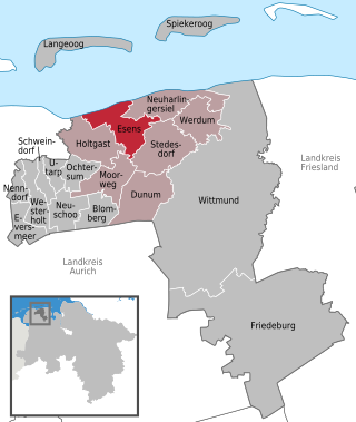
Wittmund is a Landkreis (district) in the northwestern part of Lower Saxony, Germany. It is situated in East Frisia, on the North Sea coast. Neighboring districts are Friesland, Leer and Aurich.

The Ems is a river in northwestern Germany. It runs through the states of North Rhine-Westphalia and Lower Saxony, and discharges into the Dollart Bay which is part of the Wadden Sea. Its total length is 362.4 kilometres (225.2 mi). The state border between the Lower Saxon area of East Friesland (Germany) and the province of Groningen (Netherlands), whose exact course was the subject of a border dispute between Germany and the Netherlands, runs through the Ems estuary.
Leer is a district (Landkreis) in Lower Saxony, Germany. It is bounded by the city of Emden, the districts of Aurich, Wittmund, Friesland, Ammerland, Cloppenburg and Emsland, and by the Netherlands.

The Aller is a 215-kilometre-long (134 mi) river in the states of Saxony-Anhalt and Lower Saxony in Germany. It is a right-hand, and hence eastern, tributary of the Weser and is also its largest tributary. Its last 117 kilometres (73 mi) form the Lower Aller federal waterway. The Aller was extensively straightened, widened and, in places, dyked during the 1960s to provide flood control of the river. In a 20-kilometre-long (12 mi) section near Gifhorn, the river meanders in its natural river bed.

The Havel is a river in northeastern Germany, flowing through the states of Mecklenburg-Vorpommern, Brandenburg, Berlin and Saxony-Anhalt. The 325 kilometres (202 mi) long Havel is a right tributary of the Elbe. However, the direct distance from its source to its mouth is only 94 kilometres (58 mi). For much of its length, the Havel is navigable; it provides an important link in the waterway connections between the east and west of Germany, as well as beyond.

Wittmund is a town and capital of the district of Wittmund, in Lower Saxony, Germany.

Wangerooge is one of the 32 Frisian Islands in the North Sea located close to the coasts of the Netherlands, Germany and Denmark. It is also a municipality in the district of Friesland in Lower Saxony in Germany.

Spiekeroog is one of the East Frisian Islands, off the North Sea coast of Germany. It is situated between Langeoog to its west, and Wangerooge to its east. The island belongs to the district of Wittmund, in Lower Saxony in Germany. The only village on the island is also called Spiekeroog. The island is part of the Wadden Sea World Heritage Site by the UNESCO and the Lower Saxon Wadden Sea National Park.

Esens is a municipality in the district of Wittmund, in Lower Saxony, Germany. It is situated near the North Sea coast, approx. 14 km northwest of Wittmund, and 20 km northeast of Aurich.
Holtriem is a Samtgemeinde in the district of Wittmund, in Lower Saxony, Germany. It is situated near the North Sea coast, approx. 20 km west of Wittmund, and 13 km north of Aurich. Its seat is in the village Westerholt.

MS Oldenburg is a British passenger ferry serving the island of Lundy in the Bristol Channel.

The Ilse is a river of Saxony-Anhalt and Lower Saxony, Germany.

Wustrower Dumme is a river of the German states Saxony-Anhalt and Lower Saxony. It is a roughly 32 kilometres (20 mi) long, and a left, western tributary of the Jeetzel.

Norddeich is a village in the borough of Norden in north Germany with 1,540 inhabitants (2011). It lies in northwestern East Frisia, Lower Saxony on the North Sea coast.

The Harlingerland is a strip of land on the North Sea coast of East Frisia. While today the whole of the district of Wittmund is usually described as Harlingerland, historically it specifically refers to the northern part of the present district, which formed the old Frisian state of this name, in particular, the regions around Esens and Wittmund. The region around Friedeburg still belonged at that time to the Frisian state of Östringen.

Harlesiel is a resort town on the East Frisian coast of Germany, at the mouth of the Harle River. It lies in the Wittmund district, about 1 kilometre (0.62 mi) north of Carolinensiel. It is a small town, with a population of 809 in 2009, swelled by some 4800 tourists in season.

The Harle or the Harle Seegatt is a gat in the North Sea.

Harle Airfield, German: Flugplatz Harle, is a small airfield in Wangerland in the district of Friesland in Lower Saxony, Germany, about 700 meters from Harlesiel. However, the airfield has an address of the city of Wittmund, as its only access from Harlesiel is possible, which belongs to the Wittmund district Carolinensiel.


