Wangerooge | |
|---|---|
 Aerial view of Wangerooge from the west | |
 Flag  Coat of arms | |
Location of Wangerooge within Friesland district 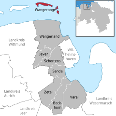 | |
 Wangerooge  Wangerooge | |
| Coordinates: 53°47′27″N7°53′57″E / 53.79083°N 7.89917°E | |
| Country | Germany |
| State | Lower Saxony |
| District | Friesland |
| Government | |
| • Mayor (2018–23) | Marcel Fangohr [1] (CDU) |
| Area | |
• Total | 7.94 km2 (3.07 sq mi) |
| Highest elevation | 17 m (56 ft) |
| Lowest elevation | 1 m (3 ft) |
| Population (2022-12-31) [2] | |
• Total | 1,197 |
| • Density | 150/km2 (390/sq mi) |
| Time zone | UTC+01:00 (CET) |
| • Summer (DST) | UTC+02:00 (CEST) |
| Postal codes | 26486 |
| Dialling codes | 04469 |
| Vehicle registration | FRI |
| Website | |
Wangerooge is one of the 32 Frisian Islands in the North Sea located close to the coasts of the Netherlands, Germany and Denmark. It is also a municipality in the district of Friesland in Lower Saxony in Germany.
Contents
- Geography
- Location
- Area
- Leisure Activities
- Special Features
- Car-Free Environment
- Ferry
- Air Travel
- Island Railway
- See also
- References
- External links
Wangerooge is one of the East Frisian Islands. It is the easternmost and smallest of the inhabited islands in this group (according to some other measurements, Baltrum is the smallest) and the only one that belonged to the historical Grand Duchy and Free State of Oldenburg between 1815 and 1947, whereas Borkum, Juist, Norderney, Baltrum, Langeoog and Spiekeroog always belonged to the county of Ostfriesland. As of the census of 2004, the island has 1,055 inhabitants. Especially in summer the island accommodates more than 7,000 visitors a day.
Wangerooge is separated from the island of Spiekeroog by a gat known as the Harle.
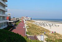
The island is attractive to tourists due to the beaches, various recreation facilities and its relaxed atmosphere. The island's slogan, visible on a sign at the harbor, emphasizes this: "God created time, but he never mentioned haste." A yearly beach volleyball tournament, usually held at the beginning of August, is one of the main attractions in the summer, and has served to modify the general impression that the island is exclusively attractive to older people and young families. In addition, windsurfing, kite-surfing and board-riding activities attract younger people.
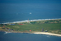
 Aerial view of Wangerooge from the east
 Wangerooge from the air, approaching the island from the south
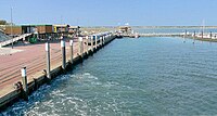
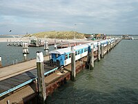
 The port of Wangerooge
 Old Lighthouse
 New Lighthouse
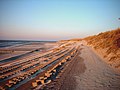 Beach and dike of Wangerooge
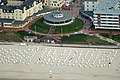 Café Pudding


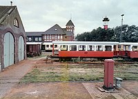
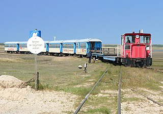
In order to guarantee a relaxed atmosphere, cars are prohibited on the island. The island can be reached by ship from Harlesiel, or it can be reached by plane via its airfield, regular service being offered from Harlesiel, Bremen, or Hamburg. The ferries leave at different times every day according to the tide. As on most East Frisian Islands, a small narrow gauge railway line, the Wangerooge Island Railway, connects the harbor to the main village.
As for historical sites and other places of interest, the island has one active lighthouse, one old lighthouse, and the Western Tower. Since the whole island used to be shifting constantly eastwards until sea defenses were built a century ago, old buildings were gradually lost to the sea. The Western Tower was built in 1597 and was originally in the east of the island.
Wangerooge is also known as the site of a historic World War II B-17 Flying Fortress crash, or rather a double crash. During a bombing mission on Hamburg on New Year's Eve, 1944, a B-17 squadron was attacked by German fighter planes on its homeward flight. While in tight formation, one plane was shot down and became entangled with the plane below it. One of the pilots managed to take control of the two aircraft and steer them back towards the German coast for an emergency landing. At the time, the two entangled aircraft were described as resembling breeding dragonflies as the ball turrets of each plane were caught in the chassis of the other. Most of the crew bailed out, while two remained and successfully made a crash landing in a field.
Wangerooge has an airfield with scheduled services.