
Aurich is a district (Landkreis) in Lower Saxony, Germany. It is bounded by the North Sea, the districts of Wittmund and Leer, and the city of Emden.

The East Frisian Islands are a chain of islands in the North Sea, off the coast of East Frisia in Lower Saxony, Germany. The islands extend for some 90 kilometres (56 mi) from west to east between the mouths of the Ems and Jade / Weser rivers and lie about 3.5 to 10 km offshore. Between the islands and the mainland are extensive mudflats, known locally as Watten, which form part of the Wadden Sea. In front of the islands are Germany's territorial waters, which occupy a much larger area than the islands themselves. The islands, the surrounding mudflats and the territorial waters form a close ecological relationship. The island group makes up about 5% of the Lower Saxony Wadden Sea National Park.
The West Frisian Islands are a chain of islands in the North Sea off the Dutch coast, along the edge of the Wadden Sea. They continue further east as the German East Frisian Islands and are part of the Frisian Islands.

The Frisian Islands, also known as the Wadden Islands or the Wadden Sea Islands, form an archipelago at the eastern edge of the North Sea in northwestern Europe, stretching from the northwest of the Netherlands through Germany to the west of Denmark. The islands shield the mudflat region of the Wadden Sea from the North Sea.
The Limfjord is a shallow part of the sea, located in Denmark where it has been regarded as a fjord ever since Viking times. However, it now has inlets both from the North Sea and Kattegat, and hence separates the North Jutlandic Island from the rest of the Jutland Peninsula. The Limfjord extends from Thyborøn Channel on the North Sea to Hals on the Kattegat. It is approximately 180 kilometres long and of an irregular shape with numerous bays, narrowings, and islands, most notably Mors, and the smaller ones Fur, Venø, Jegindø, Egholm and Livø. It is deepest at Hvalpsund.

The Jade Bight is a bight or bay on the North Sea coast of Germany. It was formerly known simply as Jade or Jahde. Because of the very low input of freshwater, it is classified as a bay rather than an estuary.

Norderney is one of the seven populated East Frisian Islands off the North Sea coast of Germany.

The Kerguelen Plateau, also known as the Kerguelen–Heard Plateau, is an oceanic plateau and large igneous province (LIP) located on the Antarctic Plate, in the southern Indian Ocean. It is about 3,000 km (1,900 mi) to the southwest of Australia and is nearly three times the size of California. The plateau extends for more than 2,200 km (1,400 mi) in a northwest–southeast direction and lies in deep water.

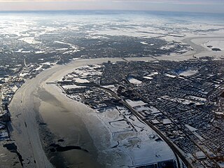
Juist is an island and municipality in the district of Aurich in Lower Saxony in Germany. The island is one of seven East Frisian Islands at the edge of the Lower Saxon Wadden Sea in the southern North Sea. It is located between Borkum Island (west), Memmert Island (southwest) and Norderney (east). The island is 17 km (11 mi) long and from 500 metres (1,600 ft) to 1 kilometre (0.62 mi) wide, depending on the tide levels. There are two villages on the island: the main village Juist, and Loog. The island is separated from Norderney by the Norderneyer Seegatt.

The Island Garden Arena was a 5,200-seat arena in West Hempstead, New York. It was built in 1957 by Arnold "Whitey" Carlson, a descendant of Swedish immigrants. Carlson's grandfather was Henrik Carlson, a noted San Diego sculptor who was the Foreign Art Director for the San Diego Exposition.
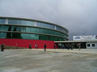
Kleine EWE Arena is a dual indoor sporting arena complex that is located in Oldenburg, Germany. It is a part of the Weser-Ems Halle multi-sporting complex, which contains two main sports arena halls, the small Kleine EWE Arena, and the large Große EWE Arena. The facility's name comes from a sponsorship arrangement with the German energy and telecommunications company EWE AG.

Afro-Eurasia is a landmass comprising the continents of Africa, Asia, and Europe. The terms are compound words of the names of its constituent parts. Afro-Eurasia has also been called the "Old World", in contrast to the "New World" of the Americas.

St. Peter's flood refers to two separate storm tides that struck the coasts of Netherlands and Northern Germany in 1651. During the first storm tide, on 22 February, the East Frisian island of Juist was split in two. During the second disaster, on 4–5 March, the city of Amsterdam was flooded.

Greece is a country in Southeastern Europe, on the Balkan Peninsula. It is bordered to the north by Albania, North Macedonia and Bulgaria; to the east by Turkey, and is surrounded to the east by the Aegean Sea, to the south by the Cretan and the Libyan seas, and to the west by the Ionian Sea which separates Greece from Italy.

Norddeich Mole is a railway station located in Norddeich, Lower Saxony, Germany. The station is located on the Emsland Railway. The train services are operated by Deutsche Bahn.

The Norderneyer Seegatt or (officially) Norderneyer Seegat is a gat in the southern North Sea.
The Wichter Ee is a gat between the East Frisian Islands of Norderney and Baltrum.

Norderney Airport is an airport on the island of Norderney in Lower Saxony, Germany. Having been opened in 1970, the airport is an integral part of the island's infrastructure, serving as a faster way to get onto or off the island compared to shipping and is available even when maritime traffic is suspended in the winter due to ice.

