
An archipelago, sometimes called an island group or island chain, is a chain, cluster, or collection of islands, or sometimes a sea containing a small number of scattered islands. Archipelagos are sometimes defined by political boundaries. For example, while they are geopolitically divided, the San Juan Islands and Gulf Islands geologically form part of a larger Gulf Archipelago.
The Wadden Sea is an intertidal zone in the southeastern part of the North Sea. It lies between the coast of northwestern continental Europe and the range of low-lying Frisian Islands, forming a shallow body of water with tidal flats and wetlands. It has a high biological diversity and is an important area for both breeding and migrating birds. In 2009, the Dutch and German parts of the Wadden Sea were inscribed on UNESCO's World Heritage List and the Danish part was added in June 2014.

Sylt is an island in northern Germany, part of Nordfriesland district, Schleswig-Holstein, well known for the distinctive shape of its shoreline. It belongs to the North Frisian Islands and is the largest island in North Frisia. The northernmost island of Germany, it is known for its tourist resorts, notably Westerland, Kampen and Wenningstedt-Braderup, as well as for its 40-kilometre-long (25-mile) sandy beach. It is frequently covered by the media in connection with its exposed situation in the North Sea and its ongoing loss of land during storm tides. Since 1927, Sylt has been connected to the mainland by the Hindenburgdamm causeway. In later years, it has been a resort for the German jet set and tourists in search of occasional celebrity sightings.

Ameland is a municipality and one of the West Frisian Islands off the north coast of the Netherlands. It consists mostly of sand dunes and is the third major island of the West Frisians. It neighbours islands Terschelling to the west and Schiermonnikoog to the east. This includes the small Engelsmanplaat and Rif sandbanks to the east.

Terschelling is a municipality and an island in the northern Netherlands, one of the West Frisian Islands. It is situated between the islands of Vlieland and Ameland.

Vlieland is a municipality and island in the northern Netherlands. The municipality of Vlieland is the second most sparsely populated municipality in the Netherlands, after Schiermonnikoog.

Texel is a municipality and an island with a population of 13,643 in North Holland, Netherlands. It is the largest and most populated island of the West Frisian Islands in the Wadden Sea. The island is situated north of Den Helder, northeast of Noorderhaaks, and southwest of Vlieland.

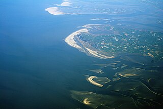
The East Frisian Islands are a chain of islands in the North Sea, off the coast of East Frisia in Lower Saxony, Germany. The islands extend for some 90 kilometres (56 mi) from west to east between the mouths of the Ems and Jade / Weser rivers and lie about 3.5 to 10 km offshore. Between the islands and the mainland are extensive mudflats, known locally as Watten, which form part of the Wadden Sea. In front of the islands are Germany's territorial waters, which occupy a much larger area than the islands themselves. The islands, the surrounding mudflats and the territorial waters form a close ecological relationship. The island group makes up about 5% of the Lower Saxony Wadden Sea National Park.
The Schleswig-Holstein Wadden Sea National Park is a national park in the Schleswig-Holstein area of the German Wadden Sea. It was founded by the Parliament of Schleswig-Holstein on 1 October 1985 by the National Park Act of 22 July 1985 and expanded significantly in 1999. Together with the Lower Saxon Wadden Sea National Park, the Hamburg Wadden Sea National Park and those parts of Elbe estuary which are not nature reserves, it forms the German part of the Wadden Sea.

The Frisian Islands, also known as the Wadden Islands or the Wadden Sea Islands, form an archipelago at the eastern edge of the North Sea in northwestern Europe, stretching from the northwest of the Netherlands through Germany to the west of Denmark. The islands shield the mudflat region of the Wadden Sea from the North Sea.
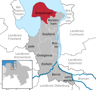
Butjadingen is a peninsula and municipality in the Wesermarsch district, in Lower Saxony, Germany.

The Heligoland Bight, also known as Helgoland Bight, is a bay which forms the southern part of the German Bight, itself a bay of the North Sea, located at the mouth of the Elbe river. The Heligoland Bight extends from the mouth of the Elbe to the islands of Heligoland and lies between the East Frisian island of Wangerooge and the North Frisian peninsula of Eiderstedt.

Mandø or Manø is one of the Danish Wadden Sea islands off the southwest coast of Jutland, Denmark in the Wadden Sea, part of the North Sea. The island covers an area of 7.63 square kilometres and had between 27-31 inhabitants in January 2022. The island is part of Esbjerg Municipality and is situated approximately 12 kilometres southwest of the ancient town of Ribe.
The Danish Wadden Sea Islands are a group of islands on the western coast of Jutland, Denmark. They have belonged to the region of Southern Denmark since January 1, 2007. Previously they belonged to the counties of South Jutland and Ribe.

The Lower Saxon Wadden Sea National Park was established in 1986 and embraces the East Frisian Islands, mudflats and salt marshes between the Bay of Dollart on the border with the Netherlands in the west and Cuxhaven as far as the Outer Elbe shipping channel in the east. The national park has an area of about 345,800 hectares (1,335 sq mi). The National Park organisation is located in Wilhelmshaven. In June 2009, the National Park became a UNESCO World Heritage Site along with the Schleswig-Holstein Wadden Sea and the Dutch Wadden Sea, highlighting its unique intertidal ecosystem and high biodiversity.

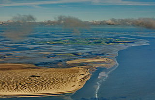
The Großer Knechtsand is a large sandbank beyond the Weser and Elbe estuaries in the eastern part of Lower Saxony's Wadden Sea off the coast of North Germany. It lies between the islands of Mellum and Neuwerk. The central area of the sandbank lies above the high water mark, forming the Hochsand of Hoher Knechtsand, which was formerly an island. The Hochsand lies 11 km west of the village of Berensch on the nearest part of the mainland in the borough of Cuxhaven in the Land Wursten.

Hallig Habel is the smallest Hallig in the German Wadden Sea, and is a bird sanctuary. It is administered by the Gröde municipality on the neighbouring island. The surface area of Habel measures 7.4 hectares with about 655 metres in length, and 100 metres width.
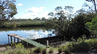
Coochin Creek is a coastal locality in the south of the Sunshine Coast Region, Queensland, Australia. The locality is named for the creek which flows through it.

Hohe Weg is an offshore lighthouse in the German Bight, located 25 km northwest of Bremerhaven, Germany. It is the oldest fixed offshore lighthouse of the Weser estuary in the Wadden Sea, having been in operation since 1856.
Mount Mellum is a rural locality in the Sunshine Coast Region, Queensland, Australia. In the 2021 census, Mount Mellum had a population of 457 people.


