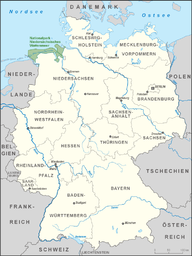
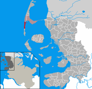
The Lower Saxon Wadden Sea National Park (German: Nationalpark Niedersächsisches Wattenmeer) was established in 1986 and embraces the East Frisian Islands, mudflats and salt marshes between the Bay of Dollart on the border with the Netherlands in the west and Cuxhaven as far as the Outer Elbe shipping channel in the east. The national park has an area of about 345,800 hectares (1,335sqmi).[2] The National Park organisation is located in Wilhelmshaven. In June 2009, the National Park became a UNESCO World Heritage Site along with the Schleswig-Holstein Wadden Sea and the Dutch Wadden Sea, highlighting its unique intertidal ecosystem and high biodiversity.[3]
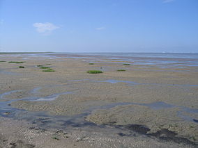
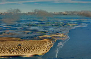
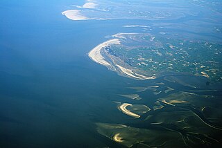
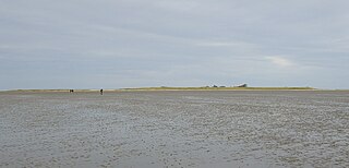
The coast of the North Sea is unusually flat. The seabed descends in places only a few centimetres per kilometre. Twice daily the tide brings sand, clay and silt into the Wadden Sea. Dunes, formed by the wind out of fine grains of sand from the exposed mudflats, characterise the coast.
The Wadden Sea is the second most productive ecosystem after the tropical rainforest - only the latter surpasses the Wadden Sea in terms of its living biomass. The forms of life found in the Wadden Sea include diatoms, snails, worms, mussels and shrimp. A typical inhabitant of the sandy mudflats is the lugworm, which lives in a U-shaped tube under the surface of the mud.
Up to 4,000 animal and plant species specialize in the unusually food-rich habitat of the Wadden Sea. For example, shelduck live on the snails, which are found in hundreds of thousands on the surface of the flats. The approximately 180,000 birds of north-western Europe's shelduck population also spends their moulting season from July to September in the Wadden Sea, as do about 200,000 eider; and about 1,000 pairs of eiders use the mudflats of the North Sea as a breeding area. Most of them breed on the island of Amrum.
At the same time, the Wadden Sea is a resting place for breeding birds from northern countries that feed here to build up the fat reserves they need for successful breeding. For example, about 10-12 million waders, geese, ducks and gulls gather in the whole Wadden Sea area.[3]
Seals may also be observed on the sandbanks of the Wadden Sea and the adjacent salt marshes, sandy beaches and sand dunes. The salt marshes are a breeding area for the pied avocet and terns as well as a habitat for the sea holly and sea lavender that bloom in summer. The typical plant of the dunes is the beachgrass, which anchors the dunes with its extensive root system.
History of the national park
Since the Ramsar Convention of 1971, the present-day national park regions and the Dollart Bay have been protected as "wetlands of international importance".[citation needed]
In 1979 Hans-Joachim Augst and Holger Wesemüller submitted a report, which developed a zoning model based on the different levels of importance of the various areas of the Wadden Sea that were worth protecting. The 1982 Lower Saxon regional development programme subsequently set the development of a national park for the "East Frisian Islands and coast" as a state planning objective. This idea was taken up in 1983, when plans for a comprehensive national park began. In early 1984 the cabinet decided to approve the national park in principle and on 1 January 1986 the national park regulation came into force.[citation needed]
Initially the national park was protected by a 1986 regulation; this was superseded in 1999 by a law. But by 11 July 2001, the law was amended by the Lower Saxon State Parliament so that many areas were removed from the scope of the national park in order to support tourism or had their zoning downgraded. To compensate, an area of sea in front of the islands of Borkum and Baltrum and the former nature reserve in the eastern part of the Dollart were added to the national park. This increased the size of the protected area from 240,000 hectares to almost 280,000 hectares.[citation needed]
In January 2002 the East Frisian conservation group Wattenrat Ost-Friesland complained to the EU Commission in Brussels about the removal or downgrading of more than 80 areas in order to support tourism; these were predominantly on the islands of East Frisia. The appeal was incorporated by the Commission into ongoing infringement proceedings against Germany (Complaint No. 2002/4099, Ref: ENV A2/MD/avdm D (2005) 6096). After more than four years, the EU Commission informed the Wattenrat-Ostfriesland in October 2006 that the complaint was closed "because the Federal Republic of Germany has now identified sufficient areas which are proposed as Special Areas of Conservation (Az: ENV A.2/MD/pd D 2006 21 119).[citation needed] The conservation group argued that this did not make sense from a nature conservation perspective, as the national park belonged to a previously designated special area of conservation and bird reserve and that, contrary to the provisions of the Natura 2000 directive, it was now in a worse state of repair.[citation needed] It claimed the EU was supporting largely economically motivated changes to the national park to provide additional tourist facilities at the cost of valuable plant habitats and bird breeding or migration sites.[citation needed]
In July 2006 the twentieth anniversary of the Wadden Sea National Park was celebrated on the beach at Neßmersiel on the initiative of the state of Lower Saxony. The Lower Saxon nature conservation organizations under the auspices of the WWF, marked the 20-year anniversary with a critical "national park balance",[4] which highlights its many conflicting uses in detail.[citation needed]
The Wadden Sea National Park is listed by the IUCN under its "Category II, National Parks".[5]
In 2008, the Wadden Sea in Lower Saxony and Schleswig Holstein was proposed to UNESCO for nomination as a UNESCO World Heritage Site. The President of the German UNESCO Commission since 2003 is Walter Hirche (FDP), the former Economic Minister in Lower Saxony from 2003 to 2009.[citation needed]
Prior to the nomination of the Wadden Sea as a UNESCO World Heritage Site, an inspection visit was held by a senior officer of the Swiss-based International Union for the Conservation of Nature (IUCN) was held in summer 2008, together with representatives of the tourism industry in and around the Wadden Sea. Following this, there were newspaper reports claiming that the UNESCO nomination was an "internationally effective marketing tool for the tourism industry" and that additional restrictions imposed for conservation purposes were not involved. On 26 June 2009, the Wadden Sea National Park was recognised as a UNESCO World Heritage Site in Seville, along with the Dutch Wadden Sea and the Schleswig-Holstein Wadden Sea National Parks. Hamburg and Denmark have so far refused to allow their mudflats to be nominated.[citation needed]
Notice board on the island of Juist
Zoning
The national park is divided into three zones with different protection status.[6]
Zone I: the most strictly protected quiet zone accounts for about 68.5% of the area and may only be entered in a few areas, such as along paths or as part of guided mudflat walks, whatever the time of year.[6]
Zone II: The intermediate zone forms 31.0% of the area and may, with the exception of designated bird reserves, be entered at any time of year on designated routes. The bird reserves may only be entered on marked trails during the main breeding, feeding and resting times of the birds from 1 April to 31 July.[6]
Zone III: The recreation zone has the smallest area, making up only 0.5% of the total, and is primarily intended for recreational purposes.[6]
The national park includes land on the islands of Baltrum, Borkum, Langeoog, Juist, Mellum, Memmert, Minsener Oog, Norderney, Spiekeroog and Wangerooge. Only the actual settlements and infrastructure on the inhabited islands are completely excluded from the national park's protection. In addition, certain areas that are used primarily for recreation (for example, stretches of beach) have limited protection under Zone III.
Im Nationalpark Wattenmeer. Documentary, 45 min., Germany, 1998, by Jens-Uwe Heins und Michael Sutor, Production: Komplett-Media-GmbH, Grünwald ( ISBN3-89672-492-4),[7]
Related Research Articles
The Wadden Sea is an intertidal zone in the southeastern part of the North Sea. It lies between the coast of northwestern continental Europe and the range of low-lying Frisian Islands, forming a shallow body of water with tidal flats and wetlands. It has a high biological diversity and is an important area for both breeding and migrating birds. In 2009, the Dutch and German parts of the Wadden Sea were inscribed on UNESCO's World Heritage List and the Danish part was added in June 2014.
Sylt is an island in northern Germany, part of Nordfriesland district, Schleswig-Holstein, and well known for the distinctive shape of its shoreline. It belongs to the North Frisian Islands and is the largest island in North Frisia. The northernmost island of Germany, it is known for its tourist resorts, notably Westerland, Kampen and Wenningstedt-Braderup, as well as for its 40-kilometre-long (25-mile) sandy beach. It is frequently covered by the media in connection with its exposed situation in the North Sea and its ongoing loss of land during storm tides. Since 1927, Sylt has been connected to the mainland by the Hindenburgdamm causeway. In later years, it has been a resort for the German jet set and tourists in search of occasional celebrity sightings.
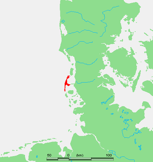
The East Frisian Islands are a chain of islands in the North Sea, off the coast of East Frisia in Lower Saxony, Germany. The islands extend for some 90 kilometres (56 mi) from west to east between the mouths of the Ems and Jade / Weser rivers and lie about 3.5 to 10 km offshore. Between the islands and the mainland are extensive mudflats, known locally as Watten, which form part of the Wadden Sea. In front of the islands are Germany's territorial waters, which occupy a much larger area than the islands themselves. The islands, the surrounding mudflats and the territorial waters form a close ecological relationship. The island group makes up about 5% of the Lower Saxony Wadden Sea National Park.
The Wadden Sea National Parks in Denmark, Germany and the Netherlands are located along the German Bight of the North Sea. In Germany and Denmark they also mark the area of the UNESCO World Heritage Site of the Wadden Sea. Divided from each other by administrative borders, they form a single ecological entity. The purpose of the national parks is the protection of the Wadden Sea ecoregion.
The Schleswig-Holstein Wadden Sea National Park is a national park in the Schleswig-Holstein area of the German Wadden Sea. It was founded by the Parliament of Schleswig-Holstein on 1 October 1985 by the National Park Act of 22 July 1985 and expanded significantly in 1999. Together with the Lower Saxon Wadden Sea National Park, the Hamburg Wadden Sea National Park and those parts of Elbe estuary which are not nature reserves, it forms the German part of the Wadden Sea.
The Hamburg Wadden Sea National Park is the smallest of the three German Wadden Sea National Parks which protect the single ecological entity of the Wadden Sea reaching from Den Helder to Esbjerg.
Amrumpronunciation (help·info) is one of the North Frisian Islands on the German North Sea coast, south of Sylt and west of Föhr. It is part of the Nordfriesland district in the federal state of Schleswig-Holstein and has approximately 2,300 inhabitants.
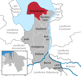
Butjadingen is a peninsula and municipality in the Wesermarsch district, in Lower Saxony, Germany.
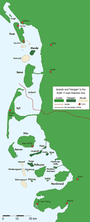
The Halligen or the halliger are small islands without protective dikes. They are variously pluralized in English as the Halligen, Halligs, Hallig islands, or Halligen islands. There are ten German halligen in the North Frisian Islands on Schleswig-Holstein's Wadden Sea-North Sea coast in the district of Nordfriesland and one hallig at the west coast of Denmark (Mandø).
Neßmersiel belongs to the municipality Dornum in the rural district Aurich in Lower Saxony, Germany. Neßmersiel is located about 5 kilometres northwest of Dornum. From 1867 to 1977, Neßmersiel belonged to Norden.
Mellum is an uninhabited island lying southeast of Wangerooge, off the coastal settlements of Horumersiel and Schillig.
North Frisian Barrier Island is the collective term for three barrier islands due west of the German Halligen in the North Frisian Islands archipelago. The shoals act as natural breakwater for the Halligen and other islands closer to land. Uninhabited, they remain one of the few areas in the Wadden Sea that are unaffected by direct human activity.
Hörnum (help·info) is a municipality in the district of Nordfriesland, in Schleswig-Holstein, Germany. It is located on the southern headland of the island of Sylt. The municipality is part of the Amt Landschaft Sylt. The economy is dominated by tourism.
Rantum is a village and a former municipality on the island of Sylt in the district of Nordfriesland, in Schleswig-Holstein, Germany. Since 1 January 2009, it has been an Ortsteil (part) of the municipality Sylt.
The Leybucht is the second largest bay in East Frisia in northwest Germany after the Dollart. The Jade Bight is larger than both, but belongs historically to Oldenburg.
Trischen (help·info) is an uninhabited island in the Meldorf Bay, about 14 kilometres off the North Sea coast of Dithmarschen in north Germany – about 12 kilometres from the Trischendamm embankment. The island belongs to the municipality of Friedrichskoog and is only occupied from March to October by a bird warden from the Nature and Biodiversity Conservation Union or NABU. Otherwise it is out-of-bounds. Trischen originated about 400 years ago and moves about 3 m per month towards Büsum on the mainland.
Südfall is a small island in the Wadden Sea off the west coast of Schleswig-Holstein, Germany, one of the ten German Hallig islands. It has a permanent population of two people. It covers an area of 0.56 square kilometres (0.22 sq mi) and is administratively part of Pellworm Municipality.
Hamburger Hallig is an area on the westcoast of Nordfriesland district in Schleswig-Holstein, Germany, that is not protected by sea dikes. It is therefore counted among the Halligen islands.
The Waddensea of Hamburg between Elbe and Weser is a German Biosphere reserve. It was added in 1992 by the UNESCO in their "man and biosphere" (MAB).
The Bay of Husum, Husum Bight or Husum Bay is a bay on the North Sea coast of the German state of Schleswig-Holstein. Its German name is used for the marketing the holiday region around the town of Husum.
This page is based on this Wikipedia article Text is available under the CC BY-SA 4.0 license; additional terms may apply. Images, videos and audio are available under their respective licenses.