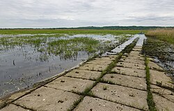
Lower Oder Valley National Park

Last updated
Lower Oder Valley National Park
Nationalpark Unteres Odertal
National Park Lower Oder Valley.jpg
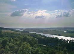
View of the lower Oder valley from the observation tower Stützkow
Relief Map of Germany.svg
Red pog.svg
Location in Brandenburg
Location Flag of Germany.svg Brandenburg, Germany
Nearest city Schwedt
Coordinates 53°03′0″N14°16′0″E / 53.05000°N 14.26667°E / 53.05000; 14.26667
Area165 km2 (64 sq mi) Total
105 km2 (41 sq mi) Germany
60 km2 (23 sq mi) Poland
Established1997
Governing bodyNationalparkverwaltung Unteres Odertal
Park 2
16303 Schwedt

The Lower Oder Valley International Park is a shared German-Polish nature reserve. It comprises the western banks of the Oder (Polish : Odra) river within the Uckermark district in the German state of Brandenburg as well as the steep eastern banks in the Gryfino and Police counties of the Polish West Pomeranian Voivodeship further north.

Contents

The German part of the core area is the Nationalpark Unteres Odertal (Lower Oder Valley National Park). There is an information centre at Criewen. The Polish part of the core area is the Park Krajobrazowy Dolina Dolnej Odry (Lower Odra Valley Landscape Park).

The area comprises 165 km2 (64 sq mi) (Germany 105 km2 (41 sq mi), Poland 60 km2 (23 sq mi)); together with adjoining nature reserves in Germany and Poland the total area is 1,172 km2 (453 sq mi). By decision of the German-Polish Environmental Council in 1992 the German, Polish and Brandenburg environment ministers as well as the voivode of Szczecin created the Lower Oder Valley International Park.

The flat western shore of the Oder features several levees, which in order to control the water level and to prevent highfloods are regularly opened in winter and spring. The water flows freely into extensive floodplains covered until April when the dikes are closed again and the remaining water is drained.
Fauna

There is a Special Protection Area (SPA) for birds. [1] These plains are habitats for birds such as the black stork, the aquatic warbler, and the corn crake. There are animals such as the European otter and the European beaver.

Flora

There are plants like the submediterranean pubescent oak.

Related Research Articles

<span class="mw-page-title-main">Brandenburg</span> State in Germany

Brandenburg, officially the State of Brandenburg, is a state in the northeast of Germany bordering the states of Mecklenburg-Vorpommern, Lower Saxony, Saxony-Anhalt, and Saxony, as well as the country of Poland. With an area of 29,480 square kilometres and a population of 2.5 million residents, it is the fifth-largest German state by area and the tenth-most populous. Potsdam is the state capital and largest city, and other major towns are Cottbus, Brandenburg an der Havel and Frankfurt (Oder).

<span class="mw-page-title-main">Lower Silesian Voivodeship</span> Voivodeship of Poland

Lower Silesian Voivodeship, or Lower Silesia Province, in southwestern Poland, is one of the 16 voivodeships (provinces) into which Poland is divided. The voivodeship was created on 1 January 1999 out of the former Wrocław, Legnica, Wałbrzych and Jelenia Góra Voivodeships, following the Polish local government reforms adopted in 1998. It covers an area of 19,946 square kilometres (7,701 sq mi), and as of 2019 has a total population of 2,899,986.

<span class="mw-page-title-main">Moravian-Silesian Region</span> Region of the Czech Republic

The Moravian-Silesian Region is one of the 14 administrative regions of the Czech Republic. Before May 2001, it was called the Ostrava Region. The region is located in the north-eastern part of its historical region of Moravia and in most of the Czech part of the historical region of Silesia. The region borders the Olomouc Region to the west and the Zlín Region to the south. It also borders two other countries – Poland to the north and Slovakia to the east.

<span class="mw-page-title-main">Schwedt</span> Town in Brandenburg, Germany

Schwedt is a town in Brandenburg, in northeastern Germany. With the official status of a Große kreisangehörige Stadt, it is the largest town of the Uckermark district, located near the river Oder, which forms the border with Poland.

<span class="mw-page-title-main">West Oder</span> River in Poland

West Oder is the western arm of the lower Oder near Szczecin, Poland along the border with Germany. It flows into the Oder Lagoon.

<span class="mw-page-title-main">Lower Lusatia</span> Geographic region in Europe

Lower Lusatia is a historical region in Central Europe, stretching from the southeast of the German state of Brandenburg to the southwest of Lubusz Voivodeship in Poland. Like adjacent Upper Lusatia in the south, Lower Lusatia is a settlement area of the West Slavic Sorbs whose endangered Lower Sorbian language is related to Upper Sorbian and Polish.

<span class="mw-page-title-main">Tyresta National Park</span>

Tyresta National Park is a national park with a surrounding nature reserve in Sweden, located in Haninge and Tyresö municipalities in Stockholm County.

<span class="mw-page-title-main">Lower Silesia</span> Historical region in Central Europe

Lower Silesia is the northwestern part of the historical and geographical region of Silesia; Upper Silesia is to the southeast.

<span class="mw-page-title-main">Kostrzyn nad Odrą</span> Place in Lubusz Voivodeship, Poland

Kostrzyn nad Odrą is a town in Gorzów County, Lubusz Voivodeship in western Poland, close to the border with Germany.

<span class="mw-page-title-main">Warta Mouth National Park</span>

The Warta Mouth National Park is the youngest of Poland's 23 national parks. It was created on 19 June 2001 in the region of the lowest stretch of the Warta river, up to its confluence with the Odra (Oder), which marks the Polish–German border. The park covers an area of 80.38 square kilometres (31.03 sq mi) within Lubusz Voivodeship.

Gmina Gryfino is an urban-rural gmina in Gryfino County, West Pomeranian Voivodeship, in north-western Poland, on the German border. Its seat is the town of Gryfino, which lies approximately 20 kilometres (12 mi) south of the regional capital Szczecin.

Gmina Chojna is an urban-rural gmina in Gryfino County, West Pomeranian Voivodeship, in north-western Poland, on the German border. Its seat is the town of Chojna, which lies approximately 32 kilometres (20 mi) south of Gryfino and 52 km (32 mi) south of the regional capital Szczecin.

<span class="mw-page-title-main">Lower Oder Valley International Park</span>

The Lower Oder Valley International Park is a shared German-Polish nature reserve. It comprises the western banks of the Oder river within the Uckermark district in the German state of Brandenburg as well as the steep eastern banks in the Gryfino and Police counties of the Polish West Pomeranian Voivodeship further north.

Lower Odra Valley Landscape Park is a designated Polish Landscape Park protected area, located in West Pomeranian Voivodeship of northwestern Poland.

Cedynia Landscape Park is a protected area in north-western Poland, bordering Germany. It was established on 1 April 1993, by order of the governor (voivode) of the then Szczecin Voivodeship. The Park covers an area of 308.5 square kilometres (119.1 sq mi). It also has a buffer zone (otulina) covering 531.2 square kilometres (205.1 sq mi).

<span class="mw-page-title-main">Rąpice</span> Village in Lubusz Voivodeship, Poland

Rąpice is a village in the administrative district of Gmina Cybinka, within Słubice County, Lubusz Voivodeship, in western Poland, close to the German border. It lies approximately 11 kilometres (7 mi) south-west of Cybinka, 29 km (18 mi) south-east of Słubice, 57 km (35 mi) west of Zielona Góra, and 77 km (48 mi) south-west of Gorzów Wielkopolski. It is located within the historic Lubusz Land.

<span class="mw-page-title-main">Oder</span> River in Central Europe

The Oder is a river in Central Europe. It is Poland's second-longest river in total length and third-longest within its borders after the Vistula and Warta. The Oder rises in the Czech Republic and flows 742 kilometres (461 mi) through western Poland, later forming 187 kilometres (116 mi) of the border between Poland and Germany as part of the Oder–Neisse line. The river ultimately flows into the Szczecin Lagoon north of Szczecin and then into three branches that empty into the Bay of Pomerania of the Baltic Sea.

<span class="mw-page-title-main">Geography of Poland</span> Geographical features of Poland

Poland is a country that extends across the North European Plain from the Sudetes and Carpathian Mountains in the south to the sandy beaches of the Baltic Sea in the north. Poland is the fifth-most populous country of the European Union and the ninth-largest country in Europe by area. The territory of Poland covers approximately 312,696 km2 (120,733 sq mi), of which 98.52% is land and 1.48% is water. The Polish coastline was estimated at 770 km (478 mi) in length. Poland's highest point is Mount Rysy, at 2,501 m (8,205 ft).

<span class="mw-page-title-main">2022 Oder environmental disaster</span> Fish kill in Central Europe

During the summer of 2022, a mass mortality event involving fish, beavers, clams, crayfish and other wildlife occurred in the Oder river.

References

  1. BirdLife International (2012) Important Bird Areas factsheet: Lower Oder valley. Downloaded from http://www.birdlife.org on 27/11/2012