Farther Pomerania Pomorze Tylne | |
|---|---|
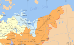
 Farther Pomerania in 1800 (in yellow) | |
| Country | |
| Historical region | Pomerania |
| Largest city | Koszalin |
| Time zone | UTC+1 (CET) |
| • Summer (DST) | UTC+2 (CEST) |
| Highways | |


Farther Pomerania, Hinder Pomerania, Rear Pomerania or Eastern Pomerania (Polish : Pomorze Tylne; German : Hinterpommern, Ostpommern), is a subregion of the historic region of Pomerania in north-western Poland, mostly within the West Pomeranian Voivodeship, while its easternmost parts are within the Pomeranian Voivodeship.
Contents
- Origin and use of the term
- Terminology
- Cities and towns
- Historical languages and dialects
- History (timeline)
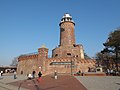
- Museums
- Sports
- See also
- References
- Notes
- Citations
It is the part of Pomerania which comprised the eastern part of the Duchy and later Province of Pomerania. It stretched roughly from the Oder River in the West to Pomerelia in the East. The Polish term Pomorze Zachodnie ("Western Pomerania") is colloquially used in contemporary Poland as a synonym for the West Pomeranian Voivodship whose borders do not match the historical ones; in Polish historical usage, it applied to all areas west of Pomerelia (i.e. to the entire narrow Pomerania).

Farther Pomerania emerged as a subdivision of the Duchy of Pomerania in the partition of 1532, then known as Pomerania-Stettin (Szczecin) and already including the historical regions Principality of Cammin (Kamień), County of Naugard (Nowogard), Land of Słupsk-Sławno, and with ties to the Lębork and Bytów Land. After the Brandenburg-Swedish partition of Pomerania, Farther Pomerania became the Brandenburg-Prussian Province of Pomerania (1653–1815). After the reorganization of the Prussian Province of Pomerania in 1815, Farther Pomerania was administered as Regierungsbezirk Köslin (Koszalin). In 1938, northern part of the dissolved Grenzmark Posen-West Prussia was merged in.
After Germany’s defeat in World War II the region was returned to the Polish state as a result of the border decisions confirmed at the Potsdam Conference (July–August 1945). The implementation of the Potsdam decisions led to the transfer of the former German administration and to large demographic changes: German civilians left or were removed from the territories east of the Oder–Neisse line, while new Polish civil authorities, municipal services and legal institutions were established in their place. [1] [2]
The postwar period was dominated by reconstruction and the organisation of public life under Polish administration. Debris clearance, restoration of roads and public buildings, reopening of schools and cultural institutions, and the reestablishment of local government bodies were carried out amid shortages of housing and resources. Polish state authorities and local administrations also launched programmes to integrate the recovered territories into the national economy and to re-establish land and property registration under Polish law. [3]
Many of the new inhabitants came from central Poland and from the eastern borderlands that had been incorporated into the Soviet Union. These population movements were part of the broader transfers and resettlements taking place across Central and Eastern Europe between 1944 and 1947. [4]
Administratively, the late 20th century saw several reforms. Before the 1999 reform, the area corresponding largely to historic Farther Pomerania was administered as the Szczecin Voivodeship and its subsequent divisions, such as Koszalin Voivodeship and Słupsk Voivodeship. Under the 1998 reform (effective 1 January 1999) these units were reorganised: the former Szczecin and Koszalin territories were largely incorporated into the newly created West Pomeranian Voivodeship, while much of the former Słupsk Voivodeship became part of the Pomeranian Voivodeship. [5] [6]