
Rügen is Germany's largest island by area. It is located off the Pomeranian coast in the Baltic Sea and belongs to the state of Mecklenburg-Western Pomerania.
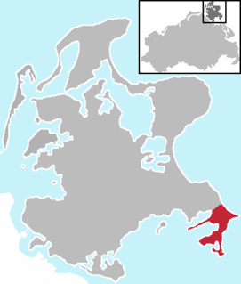
Mönchgut is a peninsula of 29.44 square kilometers with 6600 inhabitants in the southeast of Rügen island in Mecklenburg-Western Pomerania, Germany. It lies just between the Greifswalder Bodden and the rest of the Baltic Sea. Mönchgut contains the districts of Göhren and Thiessow; the peninsula is part of the Mönchgut-Granitz administration area. It is also a part of the Biosphere Reserve of Südost-Rügen.

The island of Ummanz lies in the Baltic Sea, off the west coast of the island of Rügen, and belongs, like the latter, to the county of Vorpommern-Rügen in the German state of Mecklenburg-Western Pomerania.

Bodden are briny bodies of water often forming lagoons, along the southwestern shores of the Baltic Sea, primarily in Germany's state of Mecklenburg-Vorpommern. These lagoons can be found especially around the island of Rügen, Usedom and the Fischland-Darss-Zingst peninsula. Some of them are protected reserves, forming the Western Pomerania Lagoon Area National Park.

Trent is a municipality in the Vorpommern-Rügen district, in Mecklenburg-Vorpommern, Germany.

The Großer Jasmunder Bodden belongs to the Northern Rügener Boddens and is a water body on the southern edge of the Baltic Sea in the German state of Mecklenburg-Vorpommern. It is a bodden, a type of lagoon that occurs in northern Europe especially on the coast of Pomerania. It lies within the island of Rügen, is around 14 kilometres long, an average of six kilometres wide and is up to nine metres deep with an average depth of 5.3m. The Großer Jasmunder Bodden has an area of 58.6 square kilometres; if the Breetzer Bodden, Breeger Bodden, Lebbiner Bodden, Neuendorfer Wiek and Tetzitzer See are included the total area of water comes to over 94 square kilometres.

The North Rügen Bodden are a string of West Pomeranian lagoons, known as bodden, on the Baltic Sea coast of northeastern Germany. They are almost entirely surrounded by the island of Rügen and its peninsulas. For example, in the north they are bounded by the Bug, the peninsulas of Wittow and Jasmund and the spit of Schaabe. To the south is the Muttland, the main body of Rügen Island. Amongst the highest points in the surrounding ridges of terminal moraine are the Rugard near Bergen, the Tempelberg near Bobbin, the Hoch Hilgor near Neuenkirchen, the Banzelvitz Hills near Rappin and the Mühlenberg between Buschvitz and Stedar.

The Schaproder Bodden is a bodden on the Baltic Sea coast between the island of Hiddensee in the west and the islands of Rügen and Ummanz in the east. To the north the Schaproder Bodden is linked to the Vitter Bodden by the so-called Trog between the Fährinsel and the Stolper Haken of Rügen island. To the south the bodden transitions into the Kubitzer Bodden. A boundary would be the line between the southern tips of the Hiddensee and Ummanz or the link from the Geller Haken - Insel Heuwiese.

The Udarser Wiek is a bay on Germany's Baltic Sea coast, about 8 km² in area, between the islands of Rügen in the north and Ummanz in the south. In the west, the bodden transitions into the Schaproder Bodden and in the southeast to the Gahlitz in the lake of Koselower See. At the northeast end of the bay lies the island of Öhe.

The Vitter Bodden is a type of lagoon called a bodden between the northern part of the island of Hiddensee to the west and north and the peninsula of Bug, the Wieker Bodden and the northern part of the Schaprode peninsula to the east. In the north the bodden borders on the Bay of Libben on the open Baltic Sea and in the south on the Schaproder Bodden. It is one of the West Rügen Bodden.

The Kubitzer Bodden is a type of lagoon known as a bodden on the Baltic Sea coast in the southwestern area of the island of Rügen in Germany. In the north the bodden is bounded by the Lieschow peninsula on Rügen. In the east and south the shores of the island of Rügen near Dreschvitz, Samtens and Rambin form its natural perimeter. The boundary with the Strelasund to the west is the line between the hook known as the Bessiner Haken near Bessin in the south and the tip of the Lieschow peninsula in the north.

The Schmale Heide is a 9.5-kilometre-long and roughly 2-kilometre-wide bar between the Baltic seaside resort of Binz and the village of Neu Mukran near Sassnitz on the German island of Rügen. It lies in the municipality of Binz and is bounded to the northwest by the lagoon of the Kleiner Jasmunder Bodden and to the east by the bay of Prorer Wiek.

The Wittow Ferry is a ferry service for foot passengers and vehicles from the heart of the German Baltic Sea island of Rügen, the Muttland, to the peninsula of Wittow to the north. It has also given its name to the parish of Wittower Fähre in the municipality of Wiek. This lies on the Rassower Strom at the tip of the tongue of land between the lagoons of Wieker Bodden and Breetzer Bodden on its northern shore. On the southern shore the ferry landing stage is located between the villages of Vaschvitz and Fischersiedlung in the municipality of Trent.

The Rassower Strom is a waterway that lies at the tip of the tongue of land between the lagoons of the Wieker Bodden and Breetzer Bodden and is part of the North Rügen Bodden Chain. On its southern shore is the ferry boat landing stage between the villages of Vaschvitz and Fischersiedlung in the municipality of Trent. It separates the heartland of the island of Rügen, the Muttland, from the peninsula of Wittow in the north. At its narrowest point it is 350 metres (1,150 ft) wide.

The Zudar is a peninsula on the German Baltic Sea island of Rügen. It is about 18 square kilometres in area and sharply divided.
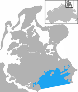
The Rügische Bodden is a bay which is part of a larger stretch of water, the Greifswalder Bodden, bounded on two sides by the German mainland and on a third by the Baltic Sea island of Rügen. It is located southeast of Rügen island between Mönchgut and the Zudar peninsula. At Mönchgut, several headlands project into the bodden: the Reddevitz Höft, the Klein Zicker and the Großer Zicker. The inlet between Rügen and the Reddevitzer Höft is known as Having; between the Reddevitzer Höft and the Großer Zicker lies the inlet of Hagensche Wiek. Other bays are the Schoritzer Wiek, the Selliner See and the Neuensiener See. Its southern boundary would be the line between the headlands of the Zudar and Mönchgut peninsulas. There are harbours in Lauterbach, Baabe and Seedorf.

The Schaabe is a bar, almost twelve kilometres long, on the German Baltic Sea island of Rügen. It joins the peninsulas of Jasmund and Wittow.

Hagensche Wiek is a cove in the east of the Rügischer Bodden that cuts deeply into the Mönchgut peninsula, the southeast tip of the German island of Rügen.

The Reddevitz Höft or Reddevitzer Höft is a peninsular forming part of the German Baltic Sea island of Rügen. It is part of the Mönchgut peninsula, with which it is linked in the southeast by a good 130 metre wide isthmus. The Reddevitzer Höft is over four kilometres long and up to 500 metres wide. In its western part, which end in a cliffed coast, the land climbs to a height of over 33 metres. At the eastern end is the village of Alt Reddevitz, part of the municipality of Middelhagen. The namen is derived from the Low German word höft for "head".

The Lake Tetzitz, Liddow Peninsula and Banzelvitz Hills Nature Reserve is a nature reserve, 1,088 hectares in area, on the German island of Rügen in Mecklenburg-Western Pomerania. It was officially designated as such on 5 November 1990 and expanded in 1994. Nearby villages are Neuenkirchen and Rappin. The area under protection is a section of the North Rügen Bodden which has a great variety of habitats and is an important roosting and breeding area for the bird world. The elements that give the reserve its name are Lake Tetzitz in the west, the peninsula of Liddow in the centre and the Banzelvitz Hills in the eastern part of the nature reserve. Lake Tetzitz is linked to the Großer Jasmunder Bodden by the channel of the Liddow Strom.


