History
The Regierungsbezirk of Stralsund was formed in 1818 as one of three Pomeranian government districts. It covered Swedish Pomerania (New Hither Pomerania [aka New Western Pomerania] and Rügen) which had fallen to Prussia in 1815. The special legal position of this territory was the reason for the creation of what was then the smallest government region in the whole of Prussia. Unlike the rest of the Province of Pomerania, neither General Prussian State Law nor the laws and ordinances of the so-called Stein-Hardenberg reforms (such as the Local Government Act of 1808), as they were called at the time, applied here. An alignment of the legal position was only gradually achieved in the second half of the 19th century, and was largely completed on the introduction of the Civil Code (BGB) in January 1900. But in some areas, special legal forms continued to exist, a situation that was unlike anywhere else in Prussia and Germany and which even went back to the time of Swedish rule, for example, the so-called Tertialrecht [ de ]. As a result, the Wismar Tribunal of Appeal [ de ], which moved from Wismar via Stralsund to Greifswald in 1802/03, still operated under this name when seated in Greifswald and continued as the final arbiter of proper jurisdiction for the region until 1848.
The first regional government was inaugurated on 5 January 1818 by the upper president of the Province of Pomerania, Johann August Sack [ de ], in his office. This followed several years of discussion about the status of the region. That produced three options:
- Form a separate province of New Hither Pomerania and Rügen
- Form a separate government region within the Province of Pomerania
- Immediately integrate it into the existing Region of Stettin
An appeal by the districts and towns to the king against the formation of the government region was dismissed. However, the Prussian system of taxation was only introduced in New Hither Pomerania following a royal cabinet order of 19 November 1821. [1]
Because of its small size the Region of Stralsund was one of those Prussian government regions which was up for re-negotiation from the outset. Only a few years after its formation there were further discussions about its future. In the end it was its aforementioned special legal status that prevented its dissolution time and again. Not until 1 October 1932 was it merged in the Stettin Region.
Administrative divisions in the mid-19th century
The Stralsund government region is divided into four counties, three of which take their name from the towns in which the district councils are located. The fourth, however, takes its name after the island of Rügen, of which it is composed alone. New Hither Pomerania has three districts: Franzburg [ de ], Greifswald [ de ], Grimmen [ de ]. Rügen forms the district of Rügen.
In ecclesiastical terms the government region is divided into eleven superintendencies, of which three cover the Franzburg district, two the Grimmen district, three the Greifswald district and three the island of Rügen.
All parishes are Protestant. [2] Only in Stralsund is there a Catholic church, to which all Catholics in the government region belong. [3]
Post-1945
In 1946, Stralsund became the seat of the virtually unchanged district of Franzburg-Barth which was renamed on this occasion as rural district of Stralsund. In 1952 on the occasion of redistricting East Germany into new administrative units the eastern part of the Franzburg-Barth became the new and smaller District of Stralsund [ de ] within the likewise new Region (Bezirk) of Rostock of the GDR. The western part went to the newly formed district of Ribnitz-Damgarten [ de ]. The old district of Grimmen lost its southern part around Loitz in 1952, which went to the district of Demmin [ de ] in the new Region of Neubrandenburg, as did the southern part of the old district of Greifswald which went to the new district of Anklam [ de ] and thus also to the Neubrandenburg Region. In 1952 the eastern part of the old district of Greifswald around Wolgast formed the new district of Wolgast [ de ] along with that part of the island of Usedom that remained within East Germany post-1945. The district of Rügen was divided in 1952 into the district of Bergen on Rügen [ de ] and Putbus [ de ], but they were merged again already in 1955. While Stralsund city maintained its independence as urban district through these changes, Greifswald was meanwhile integrated into the district of Greifswald until the 1970s.
In 1994, the districts of Grimmen, Ribnitz-Damgarten and Stralsund, now in the state of Mecklenburg-Vorpommern (aka Mecklenburg-Hither Pomerania), were merged into the new district of Northern Hither Pomerania, whilst the districts of Anklam, Greifswald and Wolgast joined Eastern Hither Pomerania. Rügen remained unchanged, Greifswald and Stralsund also retained their independence.
As part of the planned local government reform, from 2011 the districts of Rügen and Northern Hither Pomerania, and the town of Stralsund formed a reshaped district of Northern Hither Pomerania, and the districts of Uecker-Randow, together with the town of Greifswald and parts of the district of Demmin, became Hither Pomerania-Greifswald.
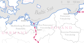
Pomerania is a historical region on the southern shore of the Baltic Sea in Central Europe, split between Poland and Germany. The western part of Pomerania belongs to the German states of Mecklenburg-Western Pomerania and Brandenburg, while the eastern part belongs to the West Pomeranian, Pomeranian and Kuyavian-Pomeranian voivodeships of Poland. Its historical border in the west is the Mecklenburg-Western Pomeranian border Urstromtal which now constitutes the border between the Mecklenburgian and Pomeranian part of Mecklenburg-Western Pomerania, while it is bounded by the Vistula River in the east. The easternmost part of Pomerania is alternatively known as Pomerelia, consisting of four sub-regions: Kashubia inhabited by ethnic Kashubians, Kociewie, Tuchola Forest and Chełmno Land.

Mecklenburg-Vorpommern, also known by its anglicized name Mecklenburg–Western Pomerania, is a state in the north-east of Germany. Of the country's sixteen states, Mecklenburg-Vorpommern ranks 14th in population; it covers an area of 23,174.93 km2 (8,947.89 sq mi), making it the sixth largest German state in area; and it is 16th in population density. Schwerin is the state capital and Rostock is the largest city. Other major cities include Neubrandenburg, Stralsund, Greifswald, Wismar, and Güstrow.

Stralsund, officially the Hanseatic City of Stralsund, is the fifth-largest city in the northeastern German federal state of Mecklenburg-Western Pomerania after Rostock, Schwerin, Neubrandenburg and Greifswald, and the second-largest city in the Pomeranian part of the state. It is located at the southern coast of the Strelasund, a sound of the Baltic Sea separating the island of Rügen from the Pomeranian mainland.

Rügen is Germany's largest island. It is located off the Pomeranian coast in the Baltic Sea and belongs to the state of Mecklenburg-Western Pomerania.

Swedish Pomerania was a dominion under the Swedish Crown from 1630 to 1815 on what is now the Baltic coast of Germany and Poland. Following the Polish War and the Thirty Years' War, Sweden held extensive control over the lands on the southern Baltic coast, including Pomerania and parts of Livonia and Prussia.

The history of Pomerania starts shortly before 1000 AD with ongoing conquests by newly arrived Polans rulers. Before that, the area was recorded nearly 2000 years ago as Germania, and in modern-day times Pomerania is split between Germany and Poland. Its name comes from the Slavic po more, which means "land at the sea".

Barth is a town in Mecklenburg-Vorpommern, Germany. It is situated at a lagoon (Bodden) of the Baltic Sea facing the Fischland-Darss-Zingst peninsula. Barth belongs to the district of Vorpommern-Rügen. It is close to the Western Pomerania Lagoon Area National Park. In 2011, it held a population of 8,706.

The Province of Pomerania was a province of Prussia from 1815 to 1945. Pomerania was established as a province of the Kingdom of Prussia in 1815, an expansion of the older Brandenburg-Prussia province of Pomerania, and then became part of the German Empire in 1871. From 1918, Pomerania was a province of the Free State of Prussia until it was dissolved in 1945 following World War II, and its territory divided between Poland and Allied-occupied Germany. The city of Stettin was the provincial capital.

Grimmen is a town in Vorpommern-Rügen, a district in the Bundesland Mecklenburg-Vorpommern, Germany. Prior to 2011, when district reforms were made in Mecklenburg-Vorpommern, it was the capital of the now bygone Nordvorpommern district, which was abolished and merged to create the district of Vorpommern-Rügen.

Franzburg is a municipality in the Vorpommern-Rügen district of Mecklenburg-Vorpommern, Germany. It is situated 20 km southwest of Stralsund. Before the Protestant Reformation, later Franzburg was the site of Neuenkamp Abbey.
Reinberg is a village and in the municipality of Sundhagen and lies between Stralsund and Greifswald on the B 105 federal road in northeastern Germany. To the north the former municipality of Reinberg borders on the Strelasund From the village of Stahlbrode that used to belong to it, there is a car ferry to the island of Rügen.

Eric II or Erich II was a member of the House of Pomerania and was the ruling Duke of Pomerania-Wolgast from 1457 to 1474. He was the son of Wartislaw IX of Pomerania-Wolgast and Sophia, daughter of Eric IV of Saxe-Lauenburg.

The Principality of Rügen was a Danish principality, formerly a duchy, consisting of the island of Rügen and the adjacent mainland from 1168 until 1325. It was governed by a local dynasty of princes of the Wizlawiden dynasty. For at least part of this period, Rügen was subject to the Holy Roman Empire.

Philipp Julius was duke of Pomerania in the Teilherzogtum Pomerania-Wolgast from 1592 to 1625.

The capitulation of Franzburg was a treaty providing for the capitulation of the Duchy of Pomerania to the forces of the Holy Roman Empire during the Thirty Years' War. It was signed on 10 November (O.S.) or 20 November (N.S.) 1627 by Bogislaw XIV, Duke of Pomerania and Hans Georg von Arnim, commander in chief of an occupation force belonging to the army of Ferdinand II, Holy Roman Emperor, led by Albrecht von Wallenstein. While the terms of the capitulation were unfavourable for the Duchy of Pomerania already, occupation became even more burdensome when the occupation force did not adhere to the restrictions outlined in Franzburg. Stralsund resisted with Danish, Swedish and Scottish support, another Danish intervention failed. Imperial occupation lasted until Swedish forces invaded in 1630, and subsequently cleared all of the Duchy of Pomerania of imperial forces until 1631.
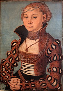
Maria of Saxony was a member of the Ernestine line of the house Wettin and a Princess of Saxony by birth and by marriage a Duchess of Pomerania.
Duchy of Pomerania-Barth was a feudal duchy of the Holy Roman Empire located in Western Pomerania that existed in the Middle Ages between 1376 and 1478, and between 1569 and 1625. The state consisted of its capital, Barth, and nearby areas. Duchy had separated from Pomerania-Wolgast in 1376 and was incorporated into Duchy of Pomerania in 1478. It was reestablished in 1569 by separation from Pomerania-Wolgast-Stolp and existed until 1625, when it was incorporated into Duchy of Pomerania.

Historical Western Pomerania, also called Cispomerania,Fore Pomerania, Front Pomerania or Hither Pomerania, is the western extremity of the historic region of Pomerania forming the southern coast of the Baltic Sea, Western Pomerania's boundaries have changed through the centuries as it belonged to various countries such as Poland, the Duchy of Pomerania, Sweden, Denmark, as well as Prussia which incorporated it as the Province of Pomerania.
The Wars of the Rügen Succession were two early 14th century conflicts fought primarily between Mecklenburg and Pomerania for control of the Danish Principality of Rügen on the southern Baltic Sea coast.
Erich Gülzow was a German local historian, philologist and publisher. He wrote books on the history of Vorpommern and the Rügen island. Through his publications on Ernst Moritz Arndt he became known beyond the borders of Pomerania.
