Schortens

Last updated
Schortens
Stephans-Kirche Schortens.jpg
Church of Saint Stephen
Flagge Schortens.svg
DEU Schortens COA.svg
Location of Schortens within Friesland district
Schortens in FRI.svgBockhornSande
Germany adm location map.svg
Red pog.svg
Schortens
Lower Saxony location map.svg
Red pog.svg
Schortens
Coordinates: 53°32′N7°57′E / 53.533°N 7.950°E / 53.533; 7.950 Coordinates: 53°32′N7°57′E / 53.533°N 7.950°E / 53.533; 7.950
Country Germany
State Lower Saxony
District Friesland
Subdivisions12 districts
Government
   Mayor (201924) Gerhard Böhling [1] (Ind.)
Area
  Total68.67 km2 (26.51 sq mi)
Elevation
6 m (20 ft)
Population
 (2020-12-31) [2]
  Total20,483
  Density300/km2 (770/sq mi)
Time zone UTC+01:00 (CET)
  Summer (DST) UTC+02:00 (CEST)
Postal codes
26419
Dialling codes 04421–23, 04461, 04468
Vehicle registration FRI
Website www.schortens.de

Schortens is a town in the district of Friesland in Lower Saxony, Germany. [3]

Contents

Division of the town

The town currently consists of the following districts: Schortens, Heidmühle, Grafschaft, Accum, Sillenstede, Schoost, Roffhausen, Middelsfähr, Addernhausen, Oestringfelde, Ostiem and Upjever. [4]

History

Graves discovered during excavations in the 1970s indicate the existence of an early human settlement in the area of Schortens already during the 5th century. [5]

In 1158 Schortens was first mentioned as "Scrotinh" in a document of Pope Adrian IV. Later the name changed to "Scrotinghe". In 1400 the place was called "Schortense". [6]

The St. Stephan Church in Schortens was built shortly after 1153 as a result of a victory of the Östringer against a superior army. [7]

In the Middle Ages, the monastery of Oestringfelde, which was also used as an asylum, was well known for its horse breeding.

During the second half of the 1900s, the naval base Wilhelmshaven contributed greatly to the development of the town. Many workers settled down in what would become central Schortens, a railway connection to Jever, established in 1871 also contributed to the development of the town. After the end of World War I, the production of warships ceased and unemployment escalated. From 1946, a steady stream of refugees have moved to Schortens, increasing the population greatly. The deployment of the Olympia-Werke typewriter factory in Roffhausen just after World War II is also seen as an important stage in the development of the town. Around 1970, this factory had jobs for 12,000 people, thus preventing unemployment in the entire region. The Olympia works had to shut down in 1992.

In 1933 Schortens united with the towns of Cleverns and Sande to form the Greater Oestringen, this union was however dissolved during World War II.

In 1936 an air force base in Upjever was opened, which is still in use today.

Schortens received municipal rights on January 21, 2005. Since June 1, 2005, the city of Schortens is an independent municipality.

Related Research Articles

Wilhelmshaven is a coastal town in Lower Saxony, Germany. It is situated on the western side of the Jade Bight, a bay of the North Sea, and has a population of 76,089. Wilhelmshaven is the centre of the "JadeBay" business region and is Germany's main military port.

Wolfenbüttel Town in Lower Saxony, Germany

Wolfenbüttel is a town in Lower Saxony, Germany, the administrative capital of Wolfenbüttel District. It is best known as the location of the internationally renowned Herzog August Library and for having the largest concentration of timber-framed buildings in Germany. It is an episcopal see of the Evangelical Lutheran Church in Brunswick. It is also home to the Jägermeister distillery, houses a campus of the Ostfalia University of Applied Sciences, and the Landesmusikakademie of Lower Saxony.

Osterholz-Scharmbeck Town in Lower Saxony, Germany

Osterholz-Scharmbeck is a town and the capital of the district of Osterholz, in Lower Saxony, Germany. Osterholz-Scharmbeck is situated in between the cities of Bremen and Bremerhaven.

Lingen, Germany Town in Lower Saxony, Germany

Lingen, officially Lingen (Ems), is a town in Lower Saxony, Germany. In 2008, its population was 52,353, and in addition there were about 5,000 people who registered the city as their secondary residence. Lingen, specifically "Lingen (Ems)" is located on the river Ems in the southern part of the Emsland District, which borders North Rhine-Westphalia in the south and the Netherlands in the west.

Butjadingen Municipality in Lower Saxony, Germany

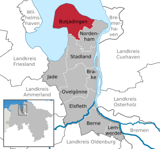
Butjadingen is a peninsula and municipality in the Wesermarsch district, in Lower Saxony, Germany.

Bremervörde Town in Lower Saxony, Germany

Bremervörde is a town in the north of the district (Landkreis) of Rotenburg, in Lower Saxony, Germany. It is situated on the Oste river near the centre of the "triangle" formed by the rivers Weser and Elbe, roughly equidistant from the cities of Hamburg, Bremen and Cuxhaven.

Papenburg Town in Lower Saxony, Germany

Papenburg is a city in the district of Emsland, Lower Saxony, Germany, situated at the river Ems. It is known for its large shipyard, the Meyer-Werft, which specializes in building cruise liners.

Rastede Municipality in Lower Saxony, Germany

Rastede is a municipality in the Ammerland district, in Lower Saxony, Germany. It is situated approximately 12 km north of Oldenburg. It is the site of the Schloss Rastede.

Faßberg Municipality in Lower Saxony, Germany

Faßberg is a municipality in the district of Celle, in Lower Saxony, Germany. It is situated approximately 35 km north of Celle, and 30 km west of Uelzen.

Bockhorn, Lower Saxony Municipality in Lower Saxony, Germany

Bockhorn is a municipality in the district of Friesland, in Lower Saxony, Germany. It is approximately 15 km southwest of Wilhelmshaven, and 30 km northwest of Oldenburg.

Langelsheim Place in Lower Saxony, Germany

Langelsheim is a town in the district of Goslar in Lower Saxony, Germany.

Winsen (Luhe) Town in Lower Saxony, Germany

Winsen (Luhe) is the capital of the district of Harburg, in Lower Saxony, Germany. It is situated on the small river Luhe, near its confluence with the Elbe, approx. 25 km southeast of Hamburg, and 20 km northwest of Lüneburg.

Lüchow Town in Lower Saxony, Germany

Lüchow (Wendland) is a city in northeastern Lower Saxony, in Germany. It is the seat of the Samtgemeinde Lüchow (Wendland), and is the capital of the district Lüchow-Dannenberg. Situated approximately 13 km north of Salzwedel, Lüchow is located on the German Framework Road. In the Polabian language, Lüchow is called Ljauchüw.

Dissen, Lower Saxony Town in Lower Saxony, Germany

Dissen am Teutoburger Wald is an old charactered town in the district of Osnabrück, in Lower Saxony, Germany. It is situated in the Teutoburg Forest, approximately 20 km southeast of Osnabrück.

Lehrte Town in Hanover, Lower Saxony, Germany

Lehrte is a town in the district of Hanover, in Lower Saxony, Germany. It is situated approximately 17 km east of Hanover. In the 19th century Lehrte was the most important railway junction in the former Kingdom of Hanover. As of the 21st century, it has a population of 43,000.

Lichtenberg, Bavaria Town in Bavaria, Germany

Lichtenberg is a town in northeastern Bavaria, lying in the district of Hof in Upper Franconia.

Mittelstenahe Municipality in Lower Saxony, Germany

Mittelstenahe is a municipality in the district of Cuxhaven, in Lower Saxony, Germany.

Burweg Municipality in Lower Saxony, Germany

Burweg is a municipality in the district of Stade, Lower Saxony, Germany.

Engelschoff Municipality in Lower Saxony, Germany

Engelschoff is a municipality in the district of Stade, Lower Saxony, Germany.

Großenwörden Municipality in Lower Saxony, Germany

Großenwörden is a municipality in the district of Stade, Lower Saxony, Germany.

References

  1. "Verzeichnis der direkt gewählten Bürgermeister/-innen und Landräte/Landrätinnen". Landesamt für Statistik Niedersachsen. April 2021.
  2. Landesamt für Statistik Niedersachsen, LSN-Online Regionaldatenbank, Tabelle A100001G: Fortschreibung des Bevölkerungsstandes, Stand 31. Dezember 2020.
  3. "Schortens - Entwicklung von der Gemeinde zur Stadt" . Retrieved 10 October 2019.
  4. "Ortsteile von Schortens". Website Stadt Schortens. Retrieved 10 October 2019.
  5. Brune, Werner, ed. (1987). Wilhelmshavener Heimatlexikon, Dritter Band. Wilhelmshaven: Brune Druck und Verlagsgesellschaft. p. 74.
  6. Brune, Werner, ed. (1987). Wilhelmshavener Heimatlexikon, Dritter Band. Wilhelmshaven: Brune Druck und Verlagsgesellschaft. p. 73.
  7. "St.-Stephanus Kirche". Ev.-luth. Kirchengemeinde Schortens. Retrieved 11 October 2019.

Bibliography