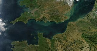
The English Channel, also called simply the Channel, is an arm of the Atlantic Ocean that separates Southern England from northern France and links to the southern part of the North Sea by the Strait of Dover at its northeastern end. It is the busiest shipping area in the world.
Sylt is an island in northern Germany, part of Nordfriesland district, Schleswig-Holstein, and well known for the distinctive shape of its shoreline. It belongs to the North Frisian Islands and is the largest island in North Frisia. The northernmost island of Germany, it is known for its tourist resorts, notably Westerland, Kampen and Wenningstedt-Braderup, as well as for its 40-kilometre-long (25-mile) sandy beach. It is frequently covered by the media in connection with its exposed situation in the North Sea and its ongoing loss of land during storm tides. Since 1927, Sylt has been connected to the mainland by the Hindenburgdamm causeway. In later years, it has been a resort for the German jet set and tourists in search of occasional celebrity sightings.

The East Frisian Islands are a chain of islands in the North Sea, off the coast of East Frisia in Lower Saxony, Germany. The islands extend for some 90 kilometres (56 mi) from west to east between the mouths of the Ems and Jade / Weser rivers and lie about 3.5 to 10 km offshore. Between the islands and the mainland are extensive mudflats, known locally as Watten, which form part of the Wadden Sea. In front of the islands are Germany's territorial waters, which occupy a much larger area than the islands themselves. The islands, the surrounding mudflats and the territorial waters form a close ecological relationship. The island group makes up about 5% of the Lower Saxony Wadden Sea National Park.

The Thames Estuary is where the River Thames meets the waters of the North Sea, in the south-east of Great Britain.

The Heligoland Bight, also known as Helgoland Bight, is a bay which forms the southern part of the German Bight, itself a bay of the North Sea, located at the mouth of the Elbe river. The Heligoland Bight extends from the mouth of the Elbe to the islands of Heligoland and lies between the East Frisian island of Wangerooge and the North Frisian peninsula of Eiderstedt.

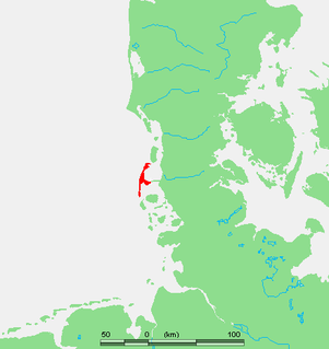
Wangerooge is one of the 32 Frisian Islands in the North Sea located close to the coasts of the Netherlands, Germany and Denmark. It is also a municipality in the district of Friesland in Lower Saxony in Germany.

The Port of Karachi is one of South Asia's largest and busiest deep-water seaports, handling about 60% of the nation's cargo located in Karachi, Pakistan. It is located on the Karachi Harbour, between Kiamari, Manora, and Kakapir, and close to Karachi's main business district and several industrial areas. The geographic position of the port places it in close proximity to major shipping routes such as the Strait of Hormuz. The administration of the port is carried out by the Karachi Port Trust, which was established in 1857.

Spiekeroog is one of the East Frisian Islands, off the North Sea coast of Germany. It is situated between Langeoog to its west, and Wangerooge to its east. The island belongs to the district of Wittmund, in Lower Saxony in Germany. The only village on the island is also called Spiekeroog. The island is part of the Wadden Sea World Heritage Site by the UNESCO and the Wittbülten National Park.
The Port of Dover is a cross-channel ferry, cruise terminal, maritime cargo and marina facility situated in Dover, Kent, south-east England. It is the nearest English port to France, at just 34 kilometres (21 mi) away, and is one of the world's busiest maritime passenger ports, with 11.7 million passengers, 2.6 million lorries, 2.2 million cars and motorcycles and 80,000 coaches passing through it in 2017, and with an annual turnover of £58.5 million a year. This contrasts with the nearby Channel Tunnel, the only fixed link between the island of Great Britain and the European mainland, which now handles an estimated 20 million passengers and 1.6 million trucks per year.
Fisherman's Gat is a much-deepened channel in the North Sea, between the final long line of shoals loosely associated with the Thames Estuary. The channel cuts across Long Sand. In the west it opens onto the nominal cut-off point of Knock Deep (north) or the Princes Channel (south) which links to the Strait of Dover. In the west it opens to Black Deep, a Thames approach.
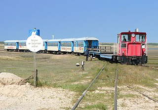
The single track Wangerooge Island Railway is an unelectrified narrow gauge railway with a track gauge of 1,000 mm located on the East Frisian island of Wangerooge off the northwestern coast of Germany. It is the most important means of transport on the island and is the only narrow gauge railway operated today by the Deutsche Bahn.
DB AutoZug GmbH was a German rail transport company that provided automobile (Motorail) and night passenger train services for Deutsche Bahn AG. It was based in Dortmund and was a wholly owned subsidiary of Deutsche Bahn AG. On 30 September 2013 the company was merged into DB AG's long-distance division DB Fernverkehr.
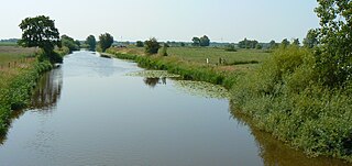
The Harle is a river of Lower Saxony, Germany, in the district of Wittmund in East Frisia.
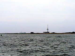
Minsener Oog, also Minser Oog or Minsener Oldeoog, is an uninhabited East Frisian island that belongs to the parish of Wangerooge in the north German district of Friesland in the state of Lower Saxony. It has been artificially enlarged through the construction of groynes.

A gat is a strait that is constantly eroded by currents flowing back and forth, such as tidal currents. It is usually a relatively narrow but deep, up to 30 m (100 ft) passage between land masses or shallow bars in an area of mudflats. A gat is sometimes a shallower passage on lagoon coasts, including those without any tidal range.

Harlesiel is a resort town on the East Frisian coast of Germany, at the mouth of the Harle River. It lies in the Wittmund district, about 1 kilometre (0.62 mi) north of Carolinensiel. It is a small town, with a population of 809 in 2009, swelled by some 4800 tourists in season.
The Norderneyer Seegatt or (officially) Norderneyer Seegat is a gat in the southern North Sea.

The Otzumer Balje is a gat in the North Sea.

The Blaue Balje is a gat in the southeastern North Sea in the outer estuary of the Jade.
