Norderneyer Seegatt

Last updated
Norderneyer Seegat between the islands of Juist and Norderney Ostfriesische Inseln (Karte).png
Norderneyer Seegat between the islands of Juist and Norderney

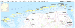
The Norderneyer Seegatt or (officially) Norderneyer Seegat is a gat in the southern North Sea.

The gat runs in a north–south direction between the East Frisian Islands of Juist to the west and Norderney to the east. There are two marked shipping channels for craft navigating from the North Sea into the Norderneyer Seegatt. From the west the gat is approached along the Schluchter and from the east the Dovetief. The Norderneyer Seegatt is subject to marked morphological changes as a result of tidal action, so that the location and depth of the channels changes continuously.

Coordinates: 53°42′16″N7°07′55″E / 53.7044°N 7.1319°E / 53.7044; 7.1319


Related Research Articles

Aurich (district) District in Lower Saxony, Germany

Aurich is a district (Landkreis) in Lower Saxony, Germany. It is bounded by the North Sea, the districts of Wittmund and Leer, and the city of Emden.

East Frisian Islands

The East Frisian Islands are a chain of islands in the North Sea, off the coast of East Frisia in Lower Saxony, Germany. The islands extend for some 90 kilometres (56 mi) from west to east between the mouths of the Ems and Jade / Weser rivers and lie about 3.5 to 10 km offshore. Between the islands and the mainland are extensive mudflats, known locally as Watten, which form part of the Wadden Sea. In front of the islands are Germany's territorial waters, which occupy a much larger area than the islands themselves. The islands, the surrounding mudflats and the territorial waters form a close ecological relationship. The island group makes up about 5% of the Lower Saxony Wadden Sea National Park.

Frisian Islands

The Frisian Islands, also known as the Wadden Islands or the Wadden Sea Islands, form an archipelago at the eastern edge of the North Sea in northwestern Europe, stretching from the northwest of the Netherlands through Germany to the west of Denmark. The islands shield the mudflat region of the Wadden Sea from the North Sea.

Thames Estuary Estuary in which the River Thames meets the waters of the North Sea

The Thames Estuary is where the River Thames meets the waters of the North Sea, in the south-east of Great Britain.

Norderney Town in Lower Saxony, Germany

Norderney is one of the seven populated East Frisian Islands off the North Sea coast of Germany.

Nore Sandbank at the mouth of the Thames Estuary

The Nore is a long bank of sand and silt running along the south-centre of the final narrowing of the Thames Estuary, England. Its south-west is the very narrow Nore Sand. Just short of the Nore's easternmost point where it fades into the channels it has a notable point once marked by a lightship on the line where the estuary of the Thames nominally becomes the North Sea. A lit buoy today stands on this often map-marked divisor: between Havengore Creek in east Essex and Warden Point on the Isle of Sheppey in Kent.

Geography of England Geographical features of England

England comprises most of the central and southern two-thirds of the island of Great Britain, in addition to a number of small islands of which the largest is the Isle of Wight. England is bordered to the north by Scotland and to the west by Wales. It is closer to continental Europe than any other part of mainland Britain, divided from France only by a 33 km (21 mi) sea gap, the English Channel. The 50 km (31 mi) Channel Tunnel, near Folkestone, directly links England to mainland Europe. The English/French border is halfway along the tunnel.

Juist Municipality in Lower Saxony, Germany

Juist is an island and municipality in the district of Aurich in Lower Saxony in Germany. The island is one of seven East Frisian Islands at the edge of the Lower Saxon Wadden Sea in the southern North Sea. It is located between Borkum Island (west), Memmert Island (southwest) and Norderney (east). The island is 17 km (11 mi) long and from 500 metres (1,600 ft) to 1 kilometre (0.62 mi) wide, depending on the tide levels. There are two villages on the island: the main village Juist, and Loog. The island is separated from Norderney by the Norderneyer Seegatt.

Wangerooge Municipality in Lower Saxony, Germany

Wangerooge is one of the 32 Frisian Islands in the North Sea located close to the coasts of the Netherlands, Germany and Denmark. It is also a municipality in the district of Friesland in Lower Saxony in Germany.

Baltrum Municipality in Lower Saxony, Germany

Baltrum is a barrier island off the coast of East Frisia, in Germany, and is a municipality in the district of Aurich, Lower Saxony. It is located in-between the chain of the seven inhabited East Frisian Islands. Baltrum is the smallest island in this chain by area and inhabitants. It has a land area of 6.5 square kilometres, and a population in (2011) of just over 500 resident inhabitants.

Spiekeroog Municipality in Lower Saxony, Germany

Spiekeroog is one of the East Frisian Islands, off the North Sea coast of Germany. It is situated between Langeoog to its west, and Wangerooge to its east. The island belongs to the district of Wittmund, in Lower Saxony in Germany. The only village on the island is also called Spiekeroog. The island is part of the Wadden Sea World Heritage Site by the UNESCO and the Lower Saxon Wadden Sea National Park.

Buise was one of the East Frisian Islands off the North Sea coast of Germany that was almost entirely engulfed by the sea in the second half of the 17th century. The only remaining part is the eastern end, known today as the island of Norderney. Buise itself was formed by the breakup of a bigger island. Two possible origins are mentioned: the breakup of the island Burchana in the flood of 1219, and the breakup of the island Bant in 1170, which also formed Juist, Borkum and Memmert.

Fisherman's Gat is a much-deepened channel in the North Sea, between the final long line of shoals loosely associated with the Thames Estuary. The channel cuts across Long Sand. In the west it opens onto the nominal cut-off point of Knock Deep (north) or the Princes Channel (south) which links to the Strait of Dover. In the west it opens to Black Deep, a Thames approach.

Lower Saxon Wadden Sea National Park National Park in Lower Saxony, Germany

The Lower Saxon Wadden Sea National Park was established in 1986 and embraces the East Frisian Islands, mudflats and salt marshes between the Bay of Dollart on the border with the Netherlands in the west and Cuxhaven as far as the Outer Elbe shipping channel in the east. The national park has an area of about 345,800 hectares (1,335 sq mi). The National Park organisation is located in Wilhelmshaven. In June 2009, the National Park became a UNESCO World Heritage Site along with the Schleswig-Holstein Wadden Sea and the Dutch Wadden Sea, highlighting its unique intertidal ecosystem and high biodiversity.

Gat (landform) Relatively narrow but deep strait that is constantly eroded by currents

A gat is a strait that is constantly eroded by currents flowing back and forth, such as tidal currents. It is usually a relatively narrow but deep, up to 30 m (100 ft) passage between land masses or shallow bars in an area of mudflats. A gat is sometimes a shallower passage on lagoon coasts, including those without any tidal range.

Harle (gat)

The Harle or the Harle Seegatt is a gat in the North Sea.

Wichter Ee

The Wichter Ee is a gat between the East Frisian Islands of Norderney and Baltrum.

Otzumer Balje

The Otzumer Balje is a gat in the North Sea.

Blaue Balje

The Blaue Balje is a gat in the southeastern North Sea in the outer estuary of the Jade.