Wittmund

Last updated
Wittmund
Flagge Wittmund.svg
DEU Wittmund COA.svg
Location of Wittmund within Wittmund district
Wittmund in WTM.svgEsensBlombergDunum
Germany adm location map.svg
Red pog.svg
Wittmund
Lower Saxony location map.svg
Red pog.svg
Wittmund
Coordinates: 53°34′30″N7°46′51″E / 53.57500°N 7.78083°E / 53.57500; 7.78083
Country Germany
State Lower Saxony
District Wittmund
Subdivisions14 districts
Government
   Mayor (202126) Rolf Claußen [1]
Area
  Total210 km2 (80 sq mi)
Elevation
4 m (13 ft)
Population
 (2021-12-31) [2]
  Total20,433
  Density97/km2 (250/sq mi)
Time zone UTC+01:00 (CET)
  Summer (DST) UTC+02:00 (CEST)
Postal codes
26409
Dialling codes 04462
Vehicle registration WTM
Website www.wittmund.de
Wittmund Wittmund 2005 c.jpg
Wittmund


Wittmund is a town and capital of the district of Wittmund, in Lower Saxony, Germany.

Contents

Geography

Wittmund is a town of 21,000 inhabitants located in Germany's historic coastal district of East Frisia, between the towns of Aurich and Jever. The town's borough covers an area of 52,000 acres (210 km2) which make it one of the largest boroughs in Lower Saxony.

While the town of Wittmund is about 9 miles (14 km) from the North Sea coast, its borough includes the little port of Harlesiel which is the starting point for ferries to the island of Wangerooge. Harlesiel is named after the Harle, a small river that starts and finishes within Wittmund borough. (A siel is a sluice in a dyke. At low tide, water from the river may flow into the sea.)

Villages: - Ardorf - Asel - Blersum - Berdum - Burhafe - Buttforde - Carolinensiel - Eggelingen - Funnix - Hovel - Leerhafe - Uttel - Willen

Towns: - Wittmund

Mayor

Since November 1, 2006, Rolf Claußen is the mayor of Wittmund. He was reelected in 2014.

History

The town of Wittmund, on the edge of the geest, and its surroundings are an ancient area of settlement. It was linked to inland East Frisia's network of roads early on and commercially oriented to the nearby coast. Around 1200, Wittmund was the hub of the rural parish (Landgemeinde) of Wangerland and was called Wiedemund or Wiedemundheim at that time. The territorial units of the rural parishes were based roughly on old Frisian districts. Esens was the administrative centre of the Harlingerland.

The chieftain family of Kankena lived in a castle in the town in the late 14th century. Around 1400, Hamburg forces occupied the castle grounds as a result of allegations that the Kankenas had supported piracy against the Hanseatic city. The release of the castle into the hands of the ruling chieftain family of tom Brok saw the Kankenas regaining possession of their estate.

The subsequent ruler of the Brokmerland, Focko Ukena, cleverly took advantage of the weakness of the Kankenas and enlisted them for military operations in the Battle of the Wild Fields, which he won. In 1454 the castle fell to the ruler of Harlingerland, Sibet Attena. In the same year, Sibet Attena united the rulers of Esens, Stedesdorf and Wittmund in order to ensure the independence of Harlingerland against the East Frisian counts. Not until 1600 was the Harlingerland, including Wittmund, finally joined to East Frisia through political and family mergers.

In 1584, the place is recorded on a card as Witmondt. Later, the town was given a district (Amt) constitution and made into an Amt as part of the new comital order. In 1730 Witmundt is recorded within the Amt of Witmundt on another map. In 1744, East Frisia was absorbed by Prussia, and then, after a brief period under Dutch/French rule, became part of the Kingdom of Hanover in 1815.

Under Hanoverian rule, the Landdrostei emerged, with the Landdrost as the highest state representative in the province. In 1866, East Frisia once again became part of Prussia. The state of Prussia initially took over the Amt structure with its existing Ämter of Aurich, Berum, Emden, Esens, Leer, Stickhausen, Weener and Wittmund. From 1884 they were transferred into the new district (Landkreis) structure. In East Frisia the new districts of Aurich, Emden (independent), Leer, Norden, Weener and Wittmund (1885) were created. Even the former Hanoverian Landdrostei were transformed into administrative provinces (Regierungsbezirke). The district hall was built in Wittmund in 1903.

Wittmund was given town rights as early as 1567 by Agnes, Countess of Rietberg. In the 17th century these rights were rescinded and were not granted again until 1929.

The Luftwaffe's 71st Tactical Fighter Squadron ( Taktisches Luftwaffengeschwader 71 "Richthofen") is based at Wittmundhafen Air Base.

Shows

N417FS N417FS.jpg
N417FS
Sculpture Stehende (2000) by Cornelia Weihe Funnix Weihe Stehende.JPG
Sculpture Stehende (2000) by Cornelia Weihe

A public event is organized each year by the Luftwaffe.

International twinnings

Wittmund is twinned with:

Notable people

See also

Related Research Articles

<span class="mw-page-title-main">Aurich (district)</span> District in Lower Saxony, Germany

Aurich is a district (Landkreis) in Lower Saxony, Germany. It is bounded by the North Sea, the districts of Wittmund and Leer, and the city of Emden.

<span class="mw-page-title-main">Wittmund (district)</span> District in Lower Saxony, Germany

Wittmund is a Landkreis (district) in the northwestern part of Lower Saxony, Germany. It is situated in East Frisia, on the North Sea coast. Neighboring districts are Friesland, Leer and Aurich.

Leer is a district (Landkreis) in Lower Saxony, Germany. It is bounded by the city of Emden, the districts of Aurich, Wittmund, Friesland, Ammerland, Cloppenburg and Emsland, and by the Netherlands.

<span class="mw-page-title-main">East Frisia</span> Historic region in Lower Saxony, Germany

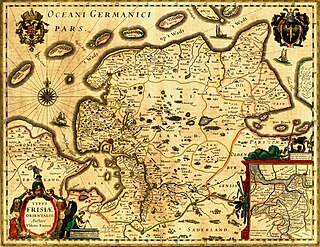
East Frisia or East Friesland is a historic region in the northwest of Lower Saxony, Germany. It is primarily located on the western half of the East Frisian peninsula, to the east of West Frisia and to the west of Landkreis Friesland.

<span class="mw-page-title-main">Leer, Lower Saxony</span> Town in Lower Saxony, Germany

Leer is a town in the district of Leer, in the northwestern part of Lower Saxony, Germany. It is situated on the river Leda, a tributary of the river Ems, near the border with the Netherlands. With 34,958 inhabitants (2021), it is the third-largest city in East Frisia after Emden and Aurich.

<span class="mw-page-title-main">Aurich</span> Town in Lower Saxony, Germany

Aurich is a town in the East Frisian region of Lower Saxony, Germany. It is the capital of the district of Aurich and is the second largest City in East Frisia, both in population, after Emden, and in area, after Wittmund.

Ems-Oriental was a department of the First French Empire in present-day Germany. It was formed in 1810, when the Kingdom of Holland was annexed by France. Its territory is part of the present-day German region of East Frisia in Lower Saxony. Its capital was Aurich. The department was subdivided into the following arrondissements and cantons :

Hero Oomkens von Esens was a Frisian nobleman, the Earl of Harlingerland. He inherited the title upon the death of his father, Sibet Attena von Esens, in 1473.

<span class="mw-page-title-main">Bunde, Germany</span> Municipality in Lower Saxony, Germany

Bunde is a municipal district in East Frisia, in Lower Saxony, Germany, about 20 km (12 mi) south of Emden, Germany, and 50 km (30 mi) east of Groningen, Netherlands. It lies on the southern tip of the Dollart, a bay of the North Sea between Germany and the Netherlands, and has a land border with the Netherlands.

<span class="mw-page-title-main">Esens, Lower Saxony</span> Town in Lower Saxony, Germany

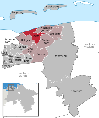
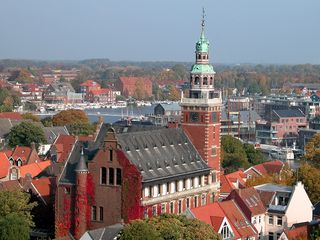
Esens is a municipality in the district of Wittmund, in Lower Saxony, Germany. It is situated near the North Sea coast, approx. 14 km northwest of Wittmund, and 20 km northeast of Aurich.

<span class="mw-page-title-main">County of East Frisia</span> Territory in the Holy Roman Empire

The County of East-Frisia was a county in the region of East Frisia in the northwest of the present-day German state of Lower Saxony.

<span class="mw-page-title-main">Ulrich I, Count of East Frisia</span> Counts of East Frisia

Ulrich I of East Frisia, first count of East Frisia was a son of the chieftain Enno Edzardisna of Norden and Greetsiel, and Gela of Manslagt.

<span class="mw-page-title-main">Cirksena</span> Ruling family of East Frisia

The House of Cirksena was the name of the ruling family of East Frisia. They descended from a line of East Frisian chieftains from Greetsiel.

tom Brok family

The tom Brok family were a powerful East Frisian line of chieftains, originally from the Norderland on the North Sea coast of Germany. From the second half of the 14th century, the tom Broks tried to gain control of East Frisia over the other chieftain families. The line of tom Brok died out in 1435.

<span class="mw-page-title-main">History of East Frisia</span>

The history of East Frisia developed rather independently from the rest of Germany because the region was relatively isolated for centuries by large stretches of bog to the south, while at the same time its people were oriented towards the sea. Thus in East Frisia in the Middle Ages there was little feudalism, instead a system of fellowship under the so-called Friesian Freedom emerged. It was not until 1464, that the House of Cirksena was enfeoffed with the Imperial County of East Frisia. Nevertheless absolutism had been, and continued to be, unknown in East Frisia. In the two centuries after about 1500, the influence of the Netherlands is discernable - politically, economically and culturally. In 1744, the county lost its independence within the Holy Roman Empire and became part of Prussia. Following the Vienna Congress of 1815, it was transferred to the Kingdom of Hanover, in 1866 it went back to Prussia and, from 1946, it has been part of the German state of Lower Saxony.

<span class="mw-page-title-main">East Frisia (peninsula)</span> All Frisian areas in Lower Saxony, Germany

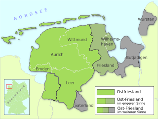
East Frisia is a collective term for all traditionally Frisian areas in Lower Saxony, Germany, which are primarily located on a peninsula between the Dollart and the Jade Bight. Along with West Frisia and North Frisia, it is one of the most commonly used subdivisions of Frisia.

The Treaty of Berum was a treaty concluded on 28 January 1600 at Berum Castle between the Count Enno III of East Frisia and the County of Rietberg, which regulated the sale of the Harlingerland to East Frisia.

<span class="mw-page-title-main">Sibet Attena</span>

Sibet Attena was an East Frisian chieftain. He was a son of Sibet of Dornum and Frouwa of Manslagt, a daughter of Enno Cirksena.

The Saxon feud was a military conflict in the years 1514–1517 between the East Frisian Count Edzard I, 'West Frisian' rebels, the city of Groningen, and Charles II, Duke of Guelders on the one hand and the Imperial Frisian hereditary governor George, Duke of Saxony – replaced by Charles V of Habsburg in 1515 – and 24 German princes. The war took place predominantly on East Frisian soil and destroyed large parts of the region.

References

  1. "Direktwahlen in Niedersachsen vom 12. September 2021" (PDF). Landesamt für Statistik Niedersachsen. 13 October 2021.
  2. "LSN-Online Regionaldatenbank, Tabelle A100001G: Fortschreibung des Bevölkerungsstandes, Stand 31. Dezember 2021" (in German). Landesamt für Statistik Niedersachsen.