Nankana Sahib is a city and capital of Nankana Sahib District in the Punjab province of Pakistan. It is named after the first Guru of the Sikhs, Guru Nanak, who was born in the city and first began preaching here. Nankana Sahib is among the most important religious sites for the Sikh religion. It is located about 91 km (57 mi) west of Lahore and about 75 km (47 mi) east of Faisalabad. According to the census of 2017 the city has a population of 110,135 inhabitants. Until 2005, it was a part of the Sheikhupura District.

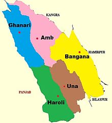
Una district is a district in the Indian state of Himachal Pradesh. Una shares its border with the Hoshiarpur and Rupnagar districts of Punjab and Kangra, Hamirpur, and Bilaspur districts of Himachal Pradesh. The terrain is generally plain with semi hills.
Hoshiarpur district is a district of Punjab state in northern India. Hoshiarpur, one of the oldest districts of Punjab, is located in the North-east part of the Punjab state and shares common boundaries with Gurdaspur district in the north-west, Jalandhar district and Kapurthala district in south-west, Kangra district and Una district of Himachal Pradesh in the north-east. Hoshiarpur district comprises 4 sub-divisions, 10 community development blocks, 9 urban local bodies and 1417 villages. The district has an area of 3365 km2. and a population of 1,586,625 persons as per census 2011.

Batala is the eighth largest city in the state of Punjab, India in terms of population after Ludhiana, Amritsar, Jalandhar, Patiala, Bathinda, Mohali and Hoshiarpur. Batala ranks as the second-oldest city after Bathinda. It is a municipal corporation in Gurdaspur district in the Majha region of the state of Punjab. It is located about 32 km from Gurdaspur, the headquarters of the district. It is also a Police district. Batala holds the status of the most populated town of the district with 31% of the district's total population. It is the biggest industrial town in the district.

Safdarabad, is city in Sheikhupura District in the Punjab province of Pakistan. The city of Safdar Abad is the capital of Safdarabad Tehsil. Its Postal code or ZIP code is 39540. Its urban area is approximately 600 acres. Until 2005 it was a tehsil of Sheikhupura District, but in that year Sheikhpura was bifurcated and the district of Nankana Sahib was created. - with Safdarabad as one of its tehsils. Now at present, once again Safdarabad has been rejoined with Sheikhupura as a Tehsil of it. The city of Safdarabad lies 95 km from Lahore the provincial capital of Punjab. The area has a population of more than 40,000 the majority of whom are Muslims. There are many engineering and medical students from Safdarabad admitted to different universities across Pakistan, including UET, Lahore.

Shaheed Bhagat Singh Nagar district is one of twenty-three districts of state of Punjab, India. It is located in Doaba region. It consists of three subdivisions, Nawanshahr, Banga, and Balachaur. There are three legislative seats in the district, Nawanshahr, Balachaur and Banga. They fall under the Anandpur Sahib Lok Sabha Constituency. Nawanshahr, the district headquarters is about 92 kilometres (57 mi) from Chandigarh, the state's capital.

Doaba, also known as Bist Doab or the Jalandhar Doab, is the region of Punjab, India that lies between the Beas River and the Sutlej River. People of this region are given the demonym "Doabia". The dialect of Punjabi spoken in Doaba is called "Doabi". The term "Doaba" or "Doab" is derived from Persian دو آب meaning "land of two rivers". The river Sutlej separates Doaba from the Malwa region to its south and the river Beas separates Doaba from the Majha region to its north.

Nawanshahr is a municipal council in Shaheed Bhagat Singh Nagar district in the Indian state of Punjab. It was previously a town that became a district in 1995.
Garhshankar is a city in Hoshiarpur district in the state of Punjab, India.
Nadaun is a historical town and a nagar panchayat in the Hamirpur district of Himachal Pradesh, India. Previously a part of the princely state of Kangra, Nadaun is presently an independent small town located on NH 3 and NH 303 in the Sivalik range foothills. It is situated on the banks of the Beas.
The Khangura is a gotra of Jat community from the Punjab region in India.
Amb is a town situated in the district of Una in Himachal Pradesh state of India. It is situated in the Shivalik region of Indian subcontinent. It is a sub-division and tehsil of Una district. The town was named Amb after the name of the goddess Amba, deity situated in nearby Chintpurni.

Bharatpur State, which is also known as the Jat State of Bharatpur historically known as the Kingdom of Bharatpur, was a Hindu Kingdom in the northern part of the Indian subcontinent. It was ruled by the Sinsinwar clan of the Hindu Jats. At the time of reign of king Suraj Mal (1755–1763) revenue of the state was 17,500,000 rupees per annual.The major architecture of this state include Lohagarh Fort and Deeg Palace.
Moranwali is a village near Banga, Punjab, India but falls in Tehsil Garhshankar (Hoshiarpur), Hoshiarpur district, in Punjab state.

The Himachal Pradesh Police is the law enforcement agency for the state of Himachal Pradesh in India. It has one state headquarters at Shimla and 12 district headquarters in the state.

Pathankot district is the northernmost district of the Indian state of Punjab. Pathankot is the district headquarters. The district was created on July 27, 2011.
Indora is a town that serves as a tehsil headquarter in the Kangra district at the borders of Himachal Pradesh, India along the dried Beas rivulet, to which Pathankot is a nearer city in plains of Punjab, while Nurpur, a town in Himachal, is farther in the hills. One can reach Indora by train up to Kandrori (KNDI) or Pathankot (PTX). Alternatively, the MDR 42 road passes through Indora connecting NH 44 with NH 503, nearest airport is Pathankot Airport.
Nagrota Surian is a town in Nagrota Surian Mandal, Kangra District, in the Indian state of Himachal Pradesh. Nagrota Surian is 45.2 km from the district headquarters Dharamshala. It is about 260 km from the state capital Shimla. Block Head office is also available in Nagrota surian.

Ramgarhia Misl was a sovereign state (misl) in the Sikh Confederacy of Punjab region in present-day India and Pakistan. The misl's name is derived from Qila Ramgarh, a place located in Ramsar, near Amritsar, which was fortified and redesigned by Ramgarhia Misl chief Jassa Singh Ramgarhia. The Ramgarhia Misl was one of the twelve major Sikh misls, and held land near Amritsar.