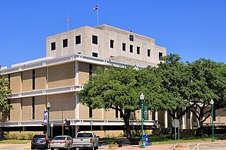
Montgomery County is a county in the U.S. state of Texas. As of the 2020 U.S. census, the county had a population of 620,443. The county seat is Conroe. The county was created by an act of the Congress of the Republic of Texas on December 14, 1837, and is named for the town of Montgomery. Between 2000 and 2010, its population grew by 55%, the 24th-fastest rate of growth of any county in the United States. Between 2010 and 2020, its population grew by 36%. According to the U.S. Census Bureau, the estimated population is 711,354 as of July 1, 2023.

Aldine is a census-designated place (CDP) in unincorporated central Harris County, Texas, United States, located within the extraterritorial jurisdiction of Houston. The population was 15,999 at the 2020 census. The community is located on the Hardy Toll Road, Union Pacific Railroad, and Farm to Market Road 525. The Aldine area is near Houston's George Bush Intercontinental Airport, the second largest aviation facility in Texas.

Humble is a city located in the Houston metropolitan area. Humble became an oil boomtown in the early 20th century when oil was first discovered there in 1904. By 1905, the Humble oilfield was the largest producing oilfield in Texas. Humble was home of the Humble Oil and Refining Company, a predecessor of Exxon.

Spring is a census-designated place (CDP) within the extraterritorial jurisdiction of Houston in Harris County, Texas, United States, part of the Houston–The Woodlands–Sugar Land metropolitan area. The population was 62,559 at the 2020 census. While the name "Spring" is popularly applied to a large area of northern Harris County and a smaller area of southern Montgomery County, the original town of Spring, now known as Old Town Spring, is at the intersection of Spring-Cypress and Hardy roads and encompasses perhaps 1 square kilometer (0.39 sq mi).

Chester W. Nimitz Senior High School is a public secondary school made up of two campuses located in unincorporated Harris County, Texas, United States. The campuses have Houston addresses. The school is located directly across the street from Lone Star College–North Harris and west of Bush Intercontinental Airport The school serves portions of Houston, the Aldine Independent School District portion of Humble, and unincorporated areas of Harris County. Nimitz is one of five comprehensive high schools in Aldine ISD. The main campus serves 10th through 12th grade, while Nimitz Ninth Grade Center serves 9th grade.
The Aldine Independent School District is a public school district based in unincorporated Harris County, Texas, United States. It serves portions of Houston and unincorporated Harris County. Aldine ISD serves the communities of Aldine, most of Greenspoint, most of East Aldine, and portions of Airline, Acres Homes, Kinwood, Bordersville, and Inwood Forest. The district is part of the taxation base for the Lone Star College System. As of 2020, Dr. LaTonya Goffney serves as superintendent of schools.

Lone Star College (LSC) is a public community college system serving the northern portions of the Greater Houston, Texas, area. In 2017, it enrolled about 95,000 students. The headquarters of the Lone Star College System are located in The Woodlands and in unincorporated Montgomery County, Texas.

Acres Homes is a neighborhood located in northwest Houston, Texas. The 9-square-mile (23 km2) mile area is loosely bounded by the city limits and West Gulf Bank Road to the north; Pinemont Drive to the south; North Shepherd Drive to the east; and Alabonson Drive to the west. Historically, it has been predominantly African American. Unincorporated for decades, it was annexed to Houston in 1967.
Spring Independent School District is a school district based in the Gordon M. Anderson Leadership Center in unincorporated Harris County, Texas, United States. It is located in north Harris County.

Inwood Forest is a community about a 3/4 mile west of historic Acres Homes in northwest Houston, Texas, United States.

Greater Greenspoint, also referred to as the North Houston District, is a 7-square-mile (18 km2) business district and a suburban neighborhood in northern Harris County, Texas, United States, located mostly within the city limits of Houston. Centered around the junction of Interstate 45 and Texas State Highway Beltway 8 near George Bush Intercontinental Airport, the area is a classic example of a planned edge city. The initial 2,000-acre (8.1 km2) retail and office development centered around Greenspoint Mall was a project of the Friendswood Development Company during the 1970s and early 1980s.

Farm to Market Road 1960 is a farm-to-market road in the U.S. state of Texas, maintained by the Texas Department of Transportation. Its western terminus is at an intersection with U.S. Highway 290 (US 290) and State Highway 6 (SH 6) in northwestern Harris County. It travels generally to the east, ending at SH 321 in Dayton in western Liberty County. FM 1960 has long been an artery in Greater Houston, though it has been shortened and re-routed over the years. Once consisting of most of the current SH 6 in West Houston as well as its current northern route, it still traverses 26 ZIP codes north of the Houston city limits.

Mercer Botanic Gardens is a public botanical gardens that includes landscaped garden beds and natural areas located at 22306 Aldine Westfield Road in northern Harris County, Texas, United States. The gardens are managed by Harris County Precinct 3 and open daily with free admission.
Westfield is an unincorporated community in Harris County, Texas, United States, located along Interstate 45 and the Union Pacific Railroad nineteen miles (30 km) north of Downtown Houston.

Bordersville is a predominantly African American community on Farm to Market Road 1960 in northeast Harris County, Texas, United States. The community, located less than one half-mile from George Bush Intercontinental Airport, has about 80% of its territory in the City of Houston and the rest in an unincorporated area.
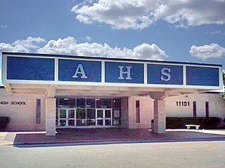
Aldine Senior High School is a public high school located in the Greenspoint district of northern Houston, Texas, United States. It is part of the Aldine Independent School District. The senior high school campus serves grades 10 through 12. The separate Aldine Ninth Grade School hosts students in grade 9.

East Aldine is a state management district in Harris County, Texas, United States, mostly in unincorporated areas, with some territory in the City of Houston. The East Aldine Improvement District, also known as the Aldine Management District, governs the area. Portions of the district coincide with the boundaries of the Aldine census-designated place. One park owned by the City of Houston, Keith-Wiess Park, is within the district limits.

The Northside is a district of Houston, Texas, United States. It is within the Greater Northside Management District.
The Airline Improvement District is a management district in unincorporated Harris County, Texas, United States, in Greater Houston and is located entirely within the postal zip code of 77037.
Harris County Housing Authority (HCHA) is the low-income housing and public housing authority of Harris County, Texas in Greater Houston. Its headquarters are in southern Houston. It mainly serves areas outside of Houston, as the Houston Housing Authority serves that city.
