
St Mary's is the largest and most populous island of the Isles of Scilly, an archipelago off the southwest coast of Cornwall in England.
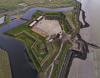
Tilbury Fort, also known historically as the Thermitage Bulwark and the West Tilbury Blockhouse, is an artillery fort on the north bank of the River Thames in England. The earliest version of the fort, comprising a small blockhouse with artillery covering the river, was constructed by King Henry VIII to protect London against attack from France as part of his Device programme. It was reinforced during the 1588 Spanish Armada invasion scare, after which it was reinforced with earthwork bastion, and Parliamentary forces used it to help secure the capital during the English Civil War of the 1640s. Following naval raids during the Anglo-Dutch Wars, the fort was enlarged by Sir Bernard de Gomme from 1670 onwards to form a star-shaped defensive work, with angular bastions, water-filled moats and two lines of guns facing onto the river.

The Device Forts, also known as Henrician castles and blockhouses, were a series of artillery fortifications built to defend the coast of England and Wales by Henry VIII. Traditionally, the Crown had left coastal defences in the hands of local lords and communities but the threat of French and Spanish invasion led the King to issue an order, called a "device", for a major programme of work between 1539 and 1547. The fortifications ranged from large stone castles positioned to protect the Downs anchorage in Kent, to small blockhouses overlooking the entrance to Milford Haven in Pembrokeshire, and earthwork bulwarks along the Essex coast. Some forts operated independently, others were designed to be mutually reinforcing. The Device programme was hugely expensive, costing a total of £376,000 ; much of this was raised from the proceeds of the Dissolution of the Monasteries a few years before.

Hurst Castle is an artillery fort established by Henry VIII on the Hurst Spit in Hampshire, England, between 1541 and 1544. It formed part of the king's Device Forts coastal protection programme against invasion from France and the Holy Roman Empire, and defended the western entrance to the Solent waterway. The early castle had a central keep and three bastions, and in 1547 was equipped with 26 guns. It was expensive to operate due to its size, but it formed one of the most powerful forts along the coast. During the English Civil War of the 1640s, Hurst was held by Parliament and was used briefly to detain King Charles I before his execution in 1649. It continued in use during the 18th century but fell into disrepair, the spit being frequented by smugglers.

Yarmouth Castle is an artillery fort built by Henry VIII in 1547 to protect Yarmouth Harbour on the Isle of Wight from the threat of French attack. Just under 100 feet (30 m) across, the square castle was initially equipped with 15 artillery guns and a garrison of 20 men. It featured an Italianate "arrow-head" bastion on its landward side; this was very different in style from the earlier circular bastions used in the Device Forts built by Henry and was the first of its kind to be constructed in England.
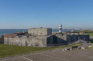
Southsea Castle, historically also known as Chaderton Castle, South Castle and Portsea Castle, is an artillery fort originally constructed by Henry VIII on Portsea Island, Hampshire, in 1544. It formed part of the King's Device programme to protect against invasion from France and the Holy Roman Empire, and defended the Solent and the eastern approach to Portsmouth. The castle had a square central keep, two rectangular gun platforms to the east and west, and two angled bastions to the front and rear, and was an early English example of the trace italienne-style of fortification popular on the Continent. The Cowdray engraving of the Battle of the Solent in 1545 depicted Henry VIII visiting the castle. Despite several serious fires, it remained in service and saw brief action at the start of the English Civil War in 1642 when it was stormed by Parliamentary forces.

Portland Castle is an artillery fort constructed by Henry VIII on the Isle of Portland, Dorset, between 1539 and 1541. It formed part of the King's Device programme to protect against invasion from France and the Holy Roman Empire, and defended the Portland Roads anchorage. The fan-shaped castle was built from Portland stone, with a curved central tower and a gun battery, flanked by two angular wings. Shortly after its construction it was armed with eleven artillery pieces, intended for use against enemy shipping, operating in partnership with its sister castle of Sandsfoot on the other side of the anchorage. During the English Civil War, Portland was taken by the Royalist supporters of King Charles I, and then survived two sieges before finally surrendering to Parliament in 1646.
Pendennis Castle is an artillery fort constructed by Henry VIII near Falmouth, Cornwall, England between 1540 and 1542. It formed part of the King's Device programme to protect against invasion from France and the Holy Roman Empire, and defended the Carrick Roads waterway at the mouth of the River Fal. The original, circular keep and gun platform was expanded at the end of the century to cope with the increasing Spanish threat, with a ring of extensive stone ramparts and bastions built around the older castle. Pendennis saw service during the English Civil War, when it was held by the Royalists, and was only taken by Parliament after a long siege in 1646. It survived the interregnum and Charles II renovated the fortress after his restoration to the throne in 1660.

Star Castle is a fortress on St Mary's, Isles of Scilly, built in 1593 by Robert Adams, Surveyor of the Royal Works (d.1595) and Francis Godolphin, Captain of the Scilly Isles, during the "Spanish invasion scare."

Kingswear Castle is an artillery fort, built to protect Dartmouth harbour in Devon, England. It was constructed between 1491 and 1502 in response to the threat of French attack and was one of the first purpose-built artillery forts in Britain. By the end of the 16th century, however, improvements in the range of artillery weapons had reduced the utility of the castle. It took part in the English Civil War and continued to be armed until the early 18th century, but fell into ruin. Restored as a summer house in 1855, in the 21st century it is managed by the Landmark Trust as a holiday let.

Bayard's Cove Fort, also known historically as Berescove or Bearscore Castle, is an English 16th-century artillery blockhouse, built to defend the harbour entrance at Dartmouth in Devon. Constructed in the early part of the century, it had eleven gunports for heavy artillery and was intended to engage enemy vessels that broke past the external defences of the Dartmouth and Kingswear castles. It remained armed during the English Civil War, but was neglected in the 18th century and used for storage. The fort was restored in the late 19th century and is now managed by English Heritage and open to visitors.

Cromwell's Castle is an artillery fort overlooking New Grimsby harbour on the island of Tresco in the Isles of Scilly. It comprises a tall, circular gun tower and an adjacent gun platform, and was designed to prevent enemy naval vessels from entering the harbour. The castle was built in two phases; Sir Robert Blake constructed the tower between 1651 and 1652 in the aftermath of the Parliamentary invasion of the islands at the end of the English Civil War, and Master Gunner Abraham Tovey added the gun platform during the War of Jenkins' Ear around 1739. The tower fell into disuse soon afterwards, and in the 21st century is managed by English Heritage and open to visitors.
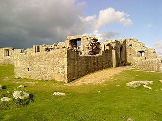
King Charles's Castle is a ruined artillery fort overlooking New Grimsby harbour on the island of Tresco in the Isles of Scilly. Built between 1548 and 1551 to protect the islands from French attack, it would have held a battery of guns and an accompanying garrison, designed to prevent enemy vessels from entering the harbour. The castle is polygonal in design, constructed from granite stone, with the gun battery at the front, and a dining room, kitchen and living accommodation at the rear. An additional defensive earthwork was constructed around it during the 17th century. The design of the castle is unusual for the period, and is only seen elsewhere in blockhouses along the River Thames.
Andrew Downing Saunders was an internationally recognised expert in artillery fortifications and Chief Inspector of Ancient Monuments and Historic Buildings in England between 1973 and 1989.

A Carnot wall is a type of loop-holed wall built in the ditch of a fort or redoubt. It takes its name from the French mathematician, politician, and military engineer, Lazare Carnot. Such walls were introduced into the design of fortifications from the early nineteenth century. As conceived by Carnot they formed part of an innovative but controversial system of fortification intended to defend against artillery and infantry attack. Carnot walls were employed, together with other elements of Carnot's system, in continental Europe in the years after the final defeat of Napoleon in 1815, especially by the Prussians, other Germans and Austrians. Their adoption was initially resisted by the French themselves and by the British.

The Old Blockhouse, also known as the Dover Fort, is a 16th-century fortification on the island of Tresco in the Isles of Scilly. It was built between 1548 and 1551 by the government of Edward VI to protect the islands against French attack.

Oliver's Battery is a ruined artillery battery on the island of Tresco in the Isles of Scilly off of Cornwall, England. It was built by the Parliamentarian admiral, Sir Robert Blake, after he invaded Tresco in April 1651 during the years of the interregnum. It was used to bombard the neighbouring island of St Mary's, which was still held by an opposing Royalist army, and forced its surrender several weeks later. The battery comprised a triangle of ramparts, constructed using earth and rubble, which, combined with the natural stone features on the site, produced a substantial, if crude, fortification. It is now ruined, and owned by the Duchy of Cornwall.

The East and West Blockhouses were Device Forts built by King Henry VIII in 1539 to protect the harbour of Milford Haven in Wales. The two blockhouses were positioned on either side of the Milford Haven Waterway in the villages of Angle and Dale respectively, overlooking the sea. The East Blockhouse was never completed, but the remains were reused as a defensive site in the Second World War. The West Blockhouse was described by contemporaries as forming a round tower with gunports, but it was demolished when West Blockhouse Fort was built on the same site in the 19th century.
Allan Brodie is a British historian and architectural historian. His expertise includes medieval ecclesiastical architecture and the history of tourism in Britain. He studied for his MA at the Courtauld Institute of Art, University of London in 1982, the subject of his dissertation being the chronology of the East End of Rochester Cathedral. Photographs contributed by Allan Brodie to the Courtauld's Conway Library archive are currently being digitised as part of the Courtauld Connects project. In 2021 he completed his Ph.D. at the University of Westminster on The Urban Character of the Early English Seaside Resort 1700–1847. The award was based on a new commentary, seven published papers and two books.


