A megalith is a large stone that has been used to construct a prehistoric structure or monument, either alone or together with other stones. There are over 35,000 structures or arrangements in Europe alone, located widely from Sweden to the Mediterranean sea.

The court cairn or court tomb is a megalithic type of chambered cairn or gallery grave. During the period, 3900–3500 BC, more than 390 court cairns were built in Ireland and over 100 in southwest Scotland. The Neolithic monuments are identified by an uncovered courtyard connected to one or more roofed and partitioned burial chambers. Many monuments were built in multiple phases in both Ireland and Scotland and later re-used in the Early Bronze Age.

A gallery grave is a form of megalithic tomb built primarily during the Neolithic Age in Europe in which the main gallery of the tomb is entered without first passing through an antechamber or hallway. There are at least four major types of gallery grave, and they may be covered with an earthen mound or rock mound.

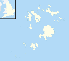
Entrance grave is a type of Neolithic and early Bronze Age chamber tomb found primarily in Great Britain. The burial monument typically consisted of a circular mound bordered by a stone curb, erected over a rectangular burial chamber and accessed by a narrow, stone lined entrance. Entrance graves have been discovered in the Isles of Scilly, west Cornwall, southeast Ireland, southwest Scotland, Brittany and the Channel Islands. They are often referred to as the Scillonian Group, named for the Scillonian Islands where the majority of entrance graves have been discovered.

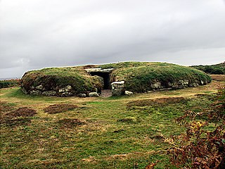
Bant's Carn is a Bronze Age entrance grave located on a steep slope on the island of St Mary's in the Isles of Scilly, England. The tomb is one of the best examples of a Scillonian entrance grave. Below Bant's Carn, lies the remains of the Iron Age village of Halangy Down.
Porth Hellick Down is a Neolithic and Bronze Age archeological site located on the island of St Mary's, in the Isles of Scilly in Great Britain. The ancient burial monument encompasses a large cairn cemetery that includes at least six entrance graves, other unchambered cairns, and a prehistoric field system. The site is notable for having the largest assembly of surviving entrance graves.

Denghoog is a Neolithic passage grave dating from around 3000 BC on the northern edge of Wenningstedt-Braderup on the German island of Sylt. The name Denghoog derives from the Söl'ring Deng (Thing) and Hoog (Hill).

Chapel Carn Brea is an elevated Hercynian granite outcrop, owned by the National Trust at the southern edge of the civil parish of St Just, Cornwall, England, United Kingdom. The hill is 5 kilometres (3.1 mi) south of St Just and 3.5 kilometres (2.2 mi) east of Sennen Cove, and just to the north of the A30 London to Land's End road, which runs through the village of Crows-an-Wra. It should not be confused with another Carn Brea, the hill overlooking the Camborne–Redruth area.
This article describes several characteristic architectural elements typical of European megalithic structures.

The dolmens of Jersey are Neolithic sites, including dolmens, in Jersey. They range over a wide period, from around 4800 BC to 2250 BC, these dates covering the periods roughly designated as Neolithic, or “new stone age”, to Chalcolithic, or “copper age”.

The Tumulus of Bougon or Necropolis of Bougon is a group of five Neolithic barrows located in Bougon, near La-Mothe-Saint-Héray, between Exoudun and Pamproux in Nouvelle-Aquitaine, France.

Parc Cwm long cairn, also known as Parc le Breos burial chamber, is a partly restored Neolithic chambered tomb, identified in 1937 as a Severn-Cotswold type of chambered long barrow. The cromlech, a megalithic burial chamber, was built around 5,850 years before present (BP), during the early Neolithic. It is about seven 1⁄2 miles (12 km) west south–west of Swansea, Wales, in what is now known as Coed y Parc Cwm at Parc le Breos, on the Gower Peninsula.

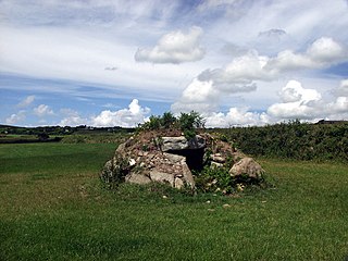
Obadiah's Barrow or Obadiah's Grave is a Neolithic entrance grave located on the island of Gugh in the Isles of Scilly. The grave sits on a steep slope on the southwestern side of Kittern Hill, the highest point on Gugh. The grave was excavated in 1901 by British archaeologist, George Bonsor.

Nordic megalith architecture is an ancient architectural style found in Northern Europe, especially Scandinavia and North Germany, that involves large slabs of stone arranged to form a structure. It emerged in northern Europe, predominantly between 3500 and 2800 BC. It was primarily a product of the Funnelbeaker culture. Between 1964 and 1974, Ewald Schuldt in Mecklenburg-Western Pomerania excavated over 100 sites of different types: simple dolmens, extended dolmens, passage graves, great dolmens, unchambered long barrows, and stone cists. In addition, there are polygonal dolmens and types that emerged later, for example, the Grabkiste and Röse. This nomenclature, which specifically derives from the German, is not used in Scandinavia where these sites are categorised by other, more general, terms, as dolmens, passage graves and stone cists.

The architecture of Scotland in the prehistoric era includes all human building within the modern borders of Scotland, before the arrival of the Romans in Britain in the first century BCE. Stone Age settlers began to build in wood in what is now Scotland from at least 8,000 years ago. The first permanent houses of stone were constructed around 6,000 years ago, as at Knap of Howar, Orkney and settlements like Skara Brae. There are also large numbers of chambered tombs and cairns from this era, particularly in the west and north. In the south and east there are earthen barrows, often linked to timber monuments of which only remnants remain. Related structures include bank barrows, cursus monuments, mortuary enclosures and timber halls. From the Bronze Age there are fewer new buildings, but there is evidence of crannogs, roundhouses built on artificial islands and of Clava cairns and the first hillforts. From the Iron Age there is evidence of substantial stone Atlantic roundhouses, which include broch towers, smaller duns. There is also evidence of about 1,000 hillforts in Scotland, most located below the Clyde-Forth line.
Brane Barrow, or Chapel Euny Barrow, is a Neolithic entrance grave located near the hamlet of Brane, Cornwall, England, UK. It is considered to be one of the smallest and best preserved burial monuments in Britain.

Tholos de El Romeral, situated 2.5 kilometres (1.6 mi) north east of the town of Antequera (Andalusia), is one of the most important examples of early Bronze Age architecture in southern Europe. Tholos de El Romeral, also known as Cueva de Romeral and Dolmen de Romeral, is a megalithic burial site built circa 1800 BCE. It is one of three tombs in the region, the others being Dolmen de Menga and Dolmen de Viera, both situated to the south west.

Din Dryfol is a Neolithic burial chamber on Anglesey, in Wales. It is a scheduled monument and is maintained by Cadw. The monument is near Bethel. Three phases of use have been identified, all dating from the Neolithic period.

Halangy Down is a prehistoric settlement located on the island of St Mary's, in the Isles of Scilly. The ancient site covers the lower slope of Halangy Down hill, overlooking the coastal inlet between the island of St. Mary's and Tresco Island. On the site are the remains of an Iron Age village, two entrance graves, prehistoric field systems, standing stones, post-medieval breastworks, and a Victorian kelp pit. The settlement was in continuous use for 500 years, from the late Iron Age until the end of the Roman occupation in Britain.

Huntersquoy chambered cairn is a Neolithic chambered cairn located on the island of Eday, in Orkney, Scotland. The monument dates from the 3rd millennium BC and is an Orkney–Cromarty type chambered cairn. Huntersquoy is a distinctive two-story burial monument with overlapping chambers. Historic Environment Scotland established the site as a scheduled monument in 1936.