Porth Hellick Down

Last updated

Porth Hellick Down
Porth Hellick Down - geograph.org.uk - 1036.jpg
Great Tomb at Porth Hellick Down
Isles of Scilly UK location map.svg
Archaeological site icon (red).svg
Shown within Isles of Scilly
Region Isles of Scilly
Coordinates 49°55′06″N6°16′52″W / 49.91829°N 6.28113°W / 49.91829; -6.28113
TypeEntrance grave
History
Foundedc.2000-1500 BC
Site notes
Excavation dates1899
ArchaeologistsGeorge Bonsor
Official namePorth Hellick Down
Designated1975
Reference no.304047 [1]

Porth Hellick Down is a Neolithic and Bronze Age archeological site located on the island of St Mary's, in the Isles of Scilly in Great Britain. The ancient burial monument encompasses a large cairn cemetery that includes at least six entrance graves, other unchambered cairns, and a prehistoric field system. The site is notable for having the largest assembly of surviving entrance graves.

Contents

Site description

Porth Hellick Down is located on the island of St Mary's in the Isles of Scilly, overlooking Porth Hellick Bay. [2] The Neolithic and Bronze Age monument encompasses a large cairn cemetery containing several burial cairns, including at least six entrance graves. It also includes an ancient linear boundary and a prehistoric field system, which stretches across the northern and north western section of the Down. It is the largest surviving group of entrance graves in the world. [1] [3]

The Great Tomb

The largest and best preserved entrance grave on the ancient site is a Bronze Age grave (2000-1500 BC) located on the northwestern slope of Porth Hellick Down. The burial monument is situated close to the boundary of a prehistoric field system. The site was excavated by the antiquarian, George Bonsor in 1899. He named the entrance grave, "The Great Tomb". Earlier unrecorded excavations at the site had left the burial chamber empty, except for a piece of pumice and a few remnants of late Bronze Age pottery fragments. Bonsor's excavation is the first excavation in Scilly to be recorded in detail. [4]

The entrance grave sits on a low, circular platform. It consists of a mound that is 12.25m in diameter and up to 1.6m in height. The mound is retained by a kerb of large slabs. The burial chamber measures 3.5m by 1.5m wide and is 1m high. The grave is roofed by four capstones, 2.5m long and 1.25m wide. The burial chamber is D-shaped with two sides that incline westwards to intersect the inner end of the passage. The entrance passage is uncovered. The Great Tomb was restored by the Ministry of Works, which included protecting the burial chamber with new turf. The restoration project damaged the tomb when they removed the grave's outer kerb. It is now in the care of English Heritage. [5] [6]

Selected monuments

The entrance grave that is positioned the furthest west on Porth Hellick Down is the grave known as the "coffin grave". The remains of the burial monument include part of the stone kerb and four capstones covering a coffin-shaped chamber. The mound contains a kerb of large stones, measuring 8.3m by 8m. The burial chamber is oriented east-west, with the entrance facing east. The chamber interior measures 7m by almost 1.5m wide across the middle, with a boat or coffin-shaped layout, the sides curving in slightly to 1m wide at the western end and 0.65m wide at the entrance. The entrance is partially blocked. The chamber walls are lined with stone slabs. Four capstones make up the chamber roof. The chamber of this entrance grave is considered to be an excellent example of a coffin or boat-shaped chamber. [7]

One of the entrance graves on Porth Hellick Down has a burial chamber that is constructed along a massive rock outcrop. The rock is integrated into the grave's structure. The burial chamber consists of a circular mound of stacked rubble, 13m in diameter and 1m high. The southern end of the chamber is lined with large slabs on its west side and a large boulder on the east side. Another large slab sits on the slab walls and provides a roof for the chamber. This grave has survived mostly intact, retaining its original form and layout. It has lost one of its capstones. The incorporation of natural rock outcropping into the grave's structure is an unusual feature of a Scillonian entrance grave. [8]

Porth Hellick Down is the site of a prehistoric linear boundary which traverses its eastern slope. The linear boundary progresses as a nearly straight line of small upright stones, up to 0.5m high and 1.5m to 6m apart. Beginning at the eastern edge of the Down, the linear boundary stretches southeast to northwest for 17m, and then continues for another 23m. The boundary measures up to 1m wide, 0.1 m high and is mainly covered by heather turf. Not typically found in prehistoric Britain, The Isles of Scilly is the setting for a number of linear boundaries that are directly associated with groupings of prehistoric burial monuments. [9]

See also

Related Research Articles

<span class="mw-page-title-main">St Mary's, Isles of Scilly</span> Human settlement in England

St Mary's is the largest and most populous island of the Isles of Scilly, an archipelago off the southwest coast of Cornwall in England, United Kingdom.

<span class="mw-page-title-main">Megalith</span> Large stone used to build a structure or monument

A megalith is a large stone that has been used to construct a prehistoric structure or monument, either alone or together with other stones. There are over 35,000 in Europe alone, located widely from Sweden to the Mediterranean sea.

<span class="mw-page-title-main">Gallery grave</span> Form of megalithic tomb

A gallery grave is a form of megalithic tomb built primarily during the Neolithic Age in Europe in which the main gallery of the tomb is entered without first passing through an antechamber or hallway. There are at least four major types of gallery grave, and they may be covered with an earthen mound or rock mound.

<span class="mw-page-title-main">Entrance grave</span> Prehistoric burial monument found primarily on the Isles of Scilly, England

Entrance grave is a type of Neolithic and early Bronze Age chamber tomb found primarily in Great Britain. The burial monument typically consisted of a circular mound bordered by a stone curb, erected over a rectangular burial chamber and accessed by a narrow, stone lined entrance. Entrance graves have been discovered in the Isles of Scilly, west Cornwall, southeast Ireland, southwest Scotland, Brittany and the Channel Islands. They are often referred to as the Scillonian Group, named for the Scillonian Islands where the majority of entrance graves have been discovered.

<span class="mw-page-title-main">Bant's Carn</span> Scillonian entrance grave

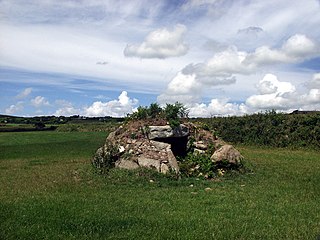
Bant's Carn is a Bronze Age entrance grave located on a steep slope on the island of St Mary's in the Isles of Scilly, England. The tomb is one of the best examples of a Scillonian entrance grave. Below Bant's Carn, lies the remains of the Iron Age village of Halangy Down.

This article describes several characteristic architectural elements typical of European megalithic structures.

<span class="mw-page-title-main">Jersey dolmens</span> Neolithic sites in Jersey

The dolmens of Jersey are neolithic sites, including dolmens, in Jersey. They range over a wide period, from around 4800 BC to 2250 BC, these dates covering the periods roughly designated as Neolithic, or “new stone age”, to Chalcolithic, or “copper age”.

<span class="mw-page-title-main">St Helen's, Isles of Scilly</span>

St Helen's is one of the fifty or so uninhabited islands in the archipelago of the Isles of Scilly and has an approximate area of 0.1885 square kilometres. On the south side of the island is one of the earliest Christian sites in Scilly, an early medieval religious complex, which is thought to be the remains of St Elidius Hermitage, an 8th-century chapel lived in by Saint Lide,. There are also the remains of an isolation hospital used to quarantine sailors with plague. The island is the major part of a Site of Special Scientific Interest and some features have been given the designation of scheduled ancient monument. Access to the island is through chartered or private boat, although there are some season trips throughout the summer. St Helen's is currently managed by the Isles of Scilly Wildlife Trust.

<span class="mw-page-title-main">Paul Ashbee</span>

Paul Ashbee was a leading British archaeologist, noted for his many excavations of barrows, or burial mounds, and for co-directing the Sutton Hoo digs from 1964 to 1972. He was also president of the Just William Society. He died of cancer on 19 August 2009, aged 91.

<span class="mw-page-title-main">Obadiah's Barrow</span> Neolithic entrance grave on the Isles of Scilly

Obadiah's Barrow or Obadiah's Grave is a Neolithic entrance grave located on the island of Gugh in the Isles of Scilly. The grave sits on a steep slope on the southwestern side of Kittern Hill, the highest point on Gugh. The grave was excavated in 1901 by British archaeologist, George Bonsor.

<span class="mw-page-title-main">Goldbusch</span>

The Goldbusch is a great dolmen, a type prehistoric grave site, that lies between Altensien and Moritzdorf on the German Baltic Sea island of Rügen. The megalithic tomb with Sprockhoff No. 508 was built between 3500 and 2800 B. C. in the New Stone Age as a megalithic site of the Funnelbeaker culture (TBK).

<span class="mw-page-title-main">Brane Barrow</span> Neolithic entrance grave in Cornwall

Brane Barrow, or Chapel Euny Barrow, is a Neolithic entrance grave located near the hamlet of Brane, Cornwall, England, UK. It is considered to be one of the smallest and best preserved burial monuments in Britain.

<span class="mw-page-title-main">Innisidgen</span> Two entrances graves in the Isles of Scilly

Innisidgen is the site of two Bronze Age entrance graves on the island of St Mary's in the Isles of Scilly. The two burial monuments, lie on a steep slope of Innisidgen Hill overlooking Crow Sound with a view towards the Eastern Isles.

<span class="mw-page-title-main">The Grey Mare and her Colts</span> Long Barrow in Dorset, England

The Grey Mare and her Colts is a megalithic chambered long barrow located near Abbotsbury in Dorset, England. It was built during the Early and Middle Neolithic periods. The tomb was partially excavated in the early nineteenth century, and was found to contain human bones and several pottery fragments.

<span class="mw-page-title-main">British megalith architecture</span> Study of those ancient cultures that built megalithic sites on the British Isles

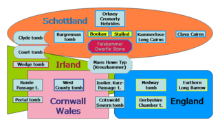
British megalith architecture is the study of those ancient cultures that built megalithic sites on the British Isles, including the research and documentation of these sites. The classification sometimes used of these cultures based on geological criteria is problematic.

<span class="mw-page-title-main">Pawton Quoit</span> Burial monument south of St. Breock, in Cornwall region, England

Pawton Quoit is a prehistoric portal dolmen, which dates to the Early and Middle Neolithic period in England. The burial monument is located near Haycrock Farm, south of St Breock, in Cornwall, England.

This is a list of scheduled monuments in Cornwall, United Kingdom. Monuments are listed by Historic England as part of the National Heritage List for England. For the scope of this list, the Isles of Sicily are included and the ceremonial county boundaries are used.

<span class="mw-page-title-main">Lesquite Quoit</span> Portal dolmen in Cornwall, United Kingdom

Lesquite Quoit, is a portal dolmen, located near Lanivet in Cornwall, United Kingdom. It is a ceremonial funerary monument built around 3500 - 2600 BC and used by Britain's early farming communities. There are only 20 portal dolmens surviving in the United Kingdom. Many have suffered from stone-robbing and degradation over time. This example is well preserved, and is a scheduled monument. In 1870, J. Polsue recorded that the local tradition was of the stones "having been thrown to their present location from Helman Tor by the Devil playing quoits."

<span class="mw-page-title-main">Halangy Down</span> Iron Age village on the island of St. Marys, in the Isles of Scilly

Halangy Down is a prehistoric settlement located on the island of St Mary's, in the Isles of Scilly. The ancient site covers the lower slope of Halangy Down hill, overlooking the coastal inlet between the island of St. Mary's and Tresco Island. On the site are the remains of an Iron Age village, two entrance graves, prehistoric field systems, standing stones, post-medieval breastworks, and a Victorian kelp pit. The settlement was in continuous use for 500 years, from the late Iron Age until the end of the Roman occupation in Britain.

<span class="mw-page-title-main">Quanterness chambered cairn</span> Neolithic chambered cairn located on Mainland, Orkney, Scotland

Quanterness chambered cairn is a Neolithic burial monument located on Mainland, Orkney in Scotland. An Iron Age roundhouse built into the cairn was discovered during excavation in the early 1970s. The dwelling was constructed around 700 BC. Also found during excavation, were the remains of 157 people, pottery remnants and other artefacts. Historic Environment Scotland established the site as a scheduled monument in 1929.

References

  1. 1 2 "Monument No. 304047". Historic England: Pastscape. Retrieved 18 July 2020.
  2. "Porth Hellick Down Burial Chamber". MapCarta. Retrieved 18 July 2020.
  3. "Kerbed platform cairn 90m north west of Old Rock, Porth Hellick Down, St Mary's". Historic England. Retrieved 18 July 2020.
  4. "Porth Hellick Down Burial Chamber, St Marys, Isles of Scilly". Historic England. Retrieved 18 July 2020.
  5. "Porth Hellick Down Burial Chamber". English Heritage. Retrieved 18 July 2020.
  6. "Prehistoric entrance grave and regular field system on north western Porth Hellick Down, St Mary's". Historic England. Retrieved 18 July 2020.
  7. "Entrance grave 80m SSE of Basin Rock, Porth Hellick Down, St Mary's". Historic England. Retrieved 19 July 2020.
  8. "Entrance grave 47m north west of Old Rock, Porth Hellick Down, St Mary's". Historic England. Retrieved 19 July 2020.
  9. "Prehistoric linear boundary south east of Horse Rock on Porth Hellick Down, St Mary's". Historic England. Retrieved 19 July 2020.