
Pulaski County is a county located in the central portion of the U.S. state of Georgia. As of the 2020 census, the population was 9,855. The county seat is Hawkinsville.
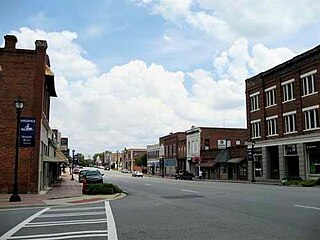
Hawkinsville is a city in and the county seat of Pulaski County, Georgia, United States. The population was 4,589 at the 2010 census.
Juno is an unincorporated community in Dawson County, Georgia, United States. It lies along State Route 183 to the northwest of the city of Dawsonville, the county seat of Dawson County. Its elevation is 1,493 feet (455 m).
Morris is an unincorporated community in southeastern Quitman County, Georgia, United States. Its elevation is 249 feet (76 m). It has a ZIP code of 39867. The community lies a short distance to the south of U.S. Route 82, to the southeast of the city of Georgetown, the county seat of Quitman County.
Elmodel is an unincorporated community in northern Baker County, Georgia, United States. It lies on State Route 37 to the northeast of the city of Newton, the county seat of Baker County. Its elevation is 161 feet (49 m).
Fruitland is an unincorporated community in northeastern Echols County, Georgia, United States. It lies on State Route 187 to the northeast of the unincorporated community of Statenville, the county seat of Echols County. Its elevation is 161 feet (49 m).
Donald is an unincorporated community in northwestern Long County, Georgia, United States. It lies a short distance away from the concurrent U.S. Routes 25 and 301, to the northwest of the city of Ludowici, the county seat of Long County. Its elevation is 79 feet (24 m).
Rockingham is an unincorporated community and census-designated place in central Bacon County, Georgia, United States. It lies along State Route 32 to the east of the city of Alma, the county seat of Bacon County. Its elevation is 194 feet (59 m). As of the 2010 census it had a population of 248.
Lothair is an unincorporated community in Treutlen County, Georgia, United States. It lies along State Route 199 (SR 199) and SR 199 Spur, a short distance north of its intersection with State Route 46, to the southwest of the city of Soperton, the county seat of Treutlen County. Its elevation is 217 feet (66 m).
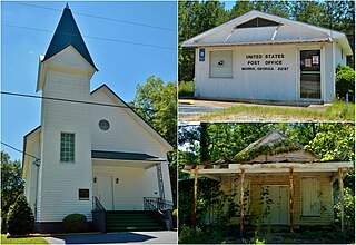
Perkins is a census-designated place and unincorporated community in Jenkins County, Georgia, United States. As of the 2010 census it had a population of 91.
Queensland is an unincorporated community in Ben Hill County, Georgia, United States. It lies along U.S. Route 129 north of the city of Fitzgerald, the county seat of Ben Hill County. Its elevation is 249 feet (76 m). The community is part of the Fitzgerald Micropolitan Statistical Area.
Jewell is an unincorporated community in Warren County, Georgia, United States. It lies along Georgia Piedmont Scenic Byway State Route 16 to the southwest of the city of Warrenton, the county seat of Warren County. Jewell's elevation is 420 feet (128 m). It has a post office with the ZIP code 31045. It is by the Ogeechee River, which is the western border of Warren County at this point.
Culverton is an unincorporated community in Hancock County, Georgia, United States. It lies along State Route 16 to the east of the city of Sparta, the county seat of Hancock County. Its elevation is 554 feet (169 m). The community is part of the Milledgeville Micropolitan Statistical Area.

Juniperjuu-nih-pər is an unincorporated community in Marion County, Georgia, United States. It lies along State Route 355 on the Talbot County line, to the north of the city of Buena Vista, the county seat of Marion County. Its elevation is 413 feet (126 m). It is part of the Columbus, Georgia Metropolitan Area.
Murrays Crossroads was an unincorporated community in Schley County, Georgia, United States. It was located at the intersection of U.S. Route 19 with State Route 240, to the north of the city of Ellaville, the county seat of Schley County. The elevation of the location is 440 feet (134 m). In the late 19th century it was a "prosperous country settlement", which had its own post office by 1884. Thomas E. Watson gave a speech at Murray's Crossroads in 1893. In 1959, it was referred to as a "town". By 2021, however, it was referred to as a "past example" of a rural community.
Willard is an unincorporated community in western Putnam County, Georgia, United States. It lies along State Route 16 between Eatonton and Monticello at an elevation of 554 feet (169 m).
Cottle is an unincorporated community in Morgan County, Kentucky, United States. It lies along U.S. Route 460 southeast of the city of West Liberty, the county seat of Morgan County. Its elevation is 801 feet (244 m).
Townsend is an unincorporated community in McIntosh County, Georgia, United States. It lies along State Route 57 northwest of the city of Darien, the county seat. Its elevation is 20 feet (6 m). It has a post office with the ZIP code 31331.
Crescent is an unincorporated community and census-designated place (CDP) in McIntosh County, Georgia, United States. It lies along State Route 99, 12 miles (19 km) north of the city of Darien, the county seat of McIntosh County. Its elevation is 30 feet (9.1 m) above sea level. It has a post office with the ZIP code 31304.


