York County is located in west-central New Brunswick, Canada. The county contains the provincial capital, Fredericton. Outside the city, farming and forestry are two major industries in the county, which is bisected by the Saint John River. The Southwest Miramichi River flows through the northern section of the county.

Woodstock is a town in Carleton County, New Brunswick, Canada on the Saint John River, 103 km upriver from Fredericton at the mouth of the Meduxnekeag River. It is near the Canada–United States border and Houlton, Maine and the intersection of Interstate 95 and the Trans-Canada Highway making it a transportation hub. It is also a service centre for the potato industry and for more than 26,000 people in the nearby communities of Hartland, Florenceville-Bristol, Centreville, Bath, Meductic, and Canterbury for shopping, employment and entertainment.
Carlingford is a Canadian rural community in Victoria County, New Brunswick on the Canada–United States border between Maine and New Brunswick. Carlingford is midway between Perth-Andover and Fort Fairfield on Route 190, also known as the Fort Road, which ends at the Canada Border Services Agency inspection station.
The Tobique River is a river in northwestern New Brunswick, Canada. The river rises from Nictau Lake in Mount Carleton Provincial Park and flows for 148 kilometres to its confluence with the Saint John River near Perth-Andover.
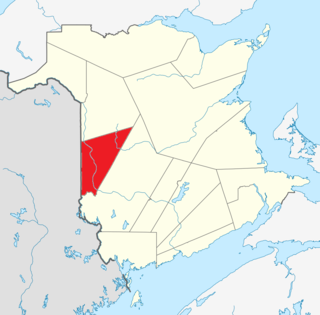
Knoxford is a Canadian rural community in Carleton County, New Brunswick. There are two parts to Knoxford: Upper Knoxford (agricultural) and Lower Knoxford (residential). It is located 3.16 km NE of Royalton. There are two churches located in Knoxford, one in Lower Knoxford and one in Upper Knoxford. Lower Knoxford is home to the Praying Band Church. While the United Baptist Church is located in Upper Knoxford.

Somerville is a Canadian rural community in Carleton County, New Brunswick.
Wakefield is in Wakefield parish in Carleton County, New Brunswick.
Peel is a Canadian rural community in Carleton County, New Brunswick. It is located on the east side of the Saint John River, 5.71 km NNW of Hartland, on the road to Stickney. It is part of Peel Parish.

Avondale is a community in the Canadian province of New Brunswick. With a population of about 100, is located off the Trans-Canada Highway about 15 km from Hartland, famous for its very long covered bridge. Avondale is about an hour's drive west from Fredericton N.B. and 30 minutes from the start of Interstate 95 in Houlton, Maine.
Grafton is a community just outside Woodstock in the Canadian province of New Brunswick. It is situated in Northampton, a parish of Carleton County.
Lakeville is a community in the Canadian province of New Brunswick. This small village is located between Centreville and Woodstock. It is located on Route 560 in Carleton County. It has two churches, a convenience store, a post office, a fire hall, a park, and a community center. In the center of this village is the Williamstown Lake.
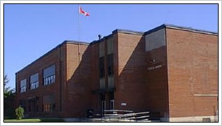
Tobique Valley Middle High School (TVMHS) is a school located in Plaster Rock, New Brunswick, Canada, that serves students from grades 6 through 12, and is within the Anglophone West School District. Constructed in 1947, TVMHS was formerly known as Tobique Valley High School until the mid-1990s when it began to house classes from grades lower than the junior high level.
Sisson Ridge is a settlement in New Brunswick 5 km (3.1 mi) west of Plaster Rock. Adjacent communities include Crombie Settlement, Anfield, Weaver, North View and Linton Corner.

New Brunswick Bible Institute (NBBI), is a conservative, evangelical Bible college that exists to educate Christian students in a thorough knowledge of the Bible as well as provide them with practical vocational training for ministry.
Coldstream is a Canadian community in Brighton Parish, New Brunswick.
Route 575 is a 15-kilometre (9.3 mi) long east-west secondary highway in the western portion of New Brunswick, Canada.
Bedell or Bedell Settlement is a settlement in Carleton County, New Brunswick.
The Becaguimec Stream is a minor tributary of the Saint John River in the Canadian Province of New Brunswick. It rises in the hilly,woods along the county line dividing Carleton County, Canada from York County, Canada in the western region of the province. Its watershed is adjacent to the South Branch of the Southwest Miramichi River, the Nashwaak River, the Keswick River and the Nackawic Stream.