Related Research Articles
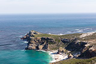
The Cape of Good Hope is a rocky headland on the Atlantic coast of the Cape Peninsula in South Africa.

The Gulf of St. Lawrence is the outlet of the North American Great Lakes via the St. Lawrence River into the Atlantic Ocean. The gulf is a semi-enclosed sea, covering an area of about 226,000 square kilometres (87,000 sq mi) and containing about 34,500 cubic kilometres (8,300 cu mi) of water, at an average depth of 152 metres (500 ft).
Lee County is located in Southwest Florida on the Gulf Coast. As of the 2020 census, the population was 760,822. The county seat is Fort Myers, and the largest city is Cape Coral with an estimated 2020 population of 194,016. The county comprises the Cape Coral–Fort Myers, FL Metropolitan Statistical Area.
Forbes Islands is a national park in Queensland, Australia, 1,962 km northwest of Brisbane in the Great Barrier Reef Marine Park Queensland and is located about 40 km North East of Kutini-Payamu National Park and Lockhart River in the Cape Weymouth area in the Coral Sea just off the small locality of Portland Roads.
Hope Islands National Park is a national park in Queensland (Australia) 1,521 km north-west of Brisbane. The park consists of four islands: East Hope and West Hope, Snapper Island and Struck Island.
Three Islands and Three Islands Reef are part of the Three Islands Group National Park in Far North Queensland, Australia, in the Coral Sea, 1,581 km (982 mi) northwest of Brisbane, about 44 km (27 mi) north-northeast of Cooktown.
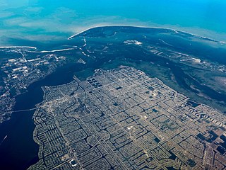
Cape Coral is a city located in Lee County, Florida, United States, on the Gulf of Mexico. Founded in 1957 and developed as a planned community, the city's population has grown to 194,016 as of the 2020 Census, a rise of 26% from the 2010 Census, making it the 130th most populous city in the United States. With an area of 120 square miles (310 km2), Cape Coral is the largest city between Tampa and Miami in both population and area. It is the largest and principal city in the Cape Coral – Fort Myers, Florida Metropolitan Statistical Area. The city has over 400 mi (640 km) of navigable waterways, more than any other city on earth.
Cape Vincent is a town in Jefferson County, New York, United States. The population was 2,777 at the 2010 census.

The Alaska Maritime National Wildlife Refuge is a United States National Wildlife Refuge comprising 2,400 islands, headlands, rocks, islets, spires and reefs in Alaska, with a total area of 4.9 million acres (20,000 km2), of which 2.64 million acres (10,700 km2) is wilderness. The refuge stretches from Cape Lisburne on the Chukchi Sea to the tip of the Aleutian Islands in the west and Forrester Island in the southern Alaska Panhandle region in the east. The refuge has diverse landforms and terrains, including tundra, rainforest, cliffs, volcanoes, beaches, lakes, and streams.

The South East Cape is a cape located at the southernmost point of the main island of Tasmania, the southernmost state of Australia. The cape is situated in the southern and south-eastern corner of the Southwest National Park, part of the Tasmanian Wilderness World Heritage Area, approximately 94 kilometres (58 mi) southwest of Hobart in Tasmania and about 65 kilometres (40 mi) east and a little south of the South West Cape.
Ravine Des Casoars Wilderness Protection Area is a protected area located on the west end of Kangaroo Island in South Australia about 80 km (50 mi) west of Kingscote. It was established in 1993 on land previously part of the Flinders Chase National Park.

Algoa Bay is a maritime bay in the Eastern Cape, South Africa. It is located in the east coast, 683 kilometres (424 mi) east of the Cape of Good Hope.
Cape Scott Provincial Park extends from Shushartie in the east, then westward around Cape Scott and south to San Josef Bay. This coastline comprises the northern tip of Vancouver Island, British Columbia. The 22,294-hectare (55,090-acre) provincial park is about 563 km (350 mi) northwest of Victoria.

Century City is a 250 ha suburb of Cape Town, South Africa. Century City is structured as a mixed-use development including entertainment, residential, retail and office components. It is located 10 km to the north-east of central Cape Town along the N1 motorway and is traversed by numerous waterways, wetlands and canals.
Mitirinchi Island is a national park in the Great Barrier Reef Marine Park Queensland, Australia, 1,947 km (1,210 mi) northwest of Brisbane. It is situated about 30 km (19 mi) north-east of Kutini-Payamu National Park and Lockhart River in the Cape Weymouth area near Portland Roads.

Cape Melville is a headland on the eastern coast of the Cape York Peninsula in Australia. To its west lies Princess Charlotte Bay. It is part of the Cape Melville National Park. Cape Melville was named Stoney Cape in 1815 by Lieutenant Charles Jeffreys on the HM Kangaroo but later renamed by him as Cape Melville

The 1999 Atlantic hurricane season was an event in the annual tropical cyclone season in the north Atlantic Ocean. This Atlantic hurricane season saw a near-average number of named tropical storms, though five of them became dangerous hurricanes of Category 4 intensity on the 5-level Saffir–Simpson scale, the most in a single season since 1886. The season officially began on June 1, 1999 and ended on November 30, 1999. These dates, adopted by convention, historically describe the period in each year when most tropical systems form. This season's first storm, Tropical Storm Arlene, formed on June 11, while the last, Hurricane Lenny, dissipated on November 23.
Lesueur Conservation Park, formerly the Cape Hart Conservation Park and the Cape Hart National Park, is a protected area in the Australian state of South Australia located on the Dudley Peninsula on Kangaroo Island.

Cape Borda is a locality in the Australian state of South Australia located on Kangaroo Island about 192 kilometres south-west of the state capital of Adelaide.

Western Kangaroo Island Marine Park is a marine protected area in the Australian state of South Australia located in the state’s coastal waters adjoining both the west coast of Kangaroo Island and Lipson Reef, an islet located to the south of Kangaroo Island.
References
| | This Queensland protected areas related article is a stub. You can help Wikipedia by expanding it. |