Hasbaya District | |
|---|---|
District | |
 Hasbaya District | |
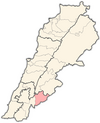
 Location in Lebanon | |
| Country | |
| Governorate | Nabatiyeh Governorate |
| Capital | Hasbaya |
| Area | |
• Total | 102 sq mi (265 km2) |
| Population | |
• Estimate (31 December 2017) | 37,784 |
| Time zone | UTC+2 (EET) |
| • Summer (DST) | UTC+3 (EEST) |
The Hasbaya District is one of the four districts in the Nabatiyeh Governorate of Lebanon. It lies in the southeast, bordering Syria to the east and Israel to the south. The capital of the district is Hasbaya, a town with a population that is mostly Druze oriented and some Christians.