
Bridgwater is a large historic market town and civil parish in Somerset, England. Its population currently stands at around 41,276 as of 2022. Bridgwater is at the edge of the Somerset Levels, in level and well-wooded country. The town lies along both sides of the River Parrett; it has been a major inland port and trading centre since the industrial revolution. Most of its industrial bases still stand today. Its larger neighbour, Taunton, is linked to Bridgwater via a canal, the M5 motorway and the GWR railway line.

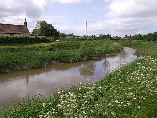
The River Parrett flows through the counties of Dorset and Somerset in South West England, from its source in the Thorney Mills springs in the hills around Chedington in Dorset. Flowing northwest through Somerset and the Somerset Levels to its mouth at Burnham-on-Sea, into the Bridgwater Bay nature reserve on the Bristol Channel, the Parrett and its tributaries drain an area of 660 square miles (1,700 km2) – about 50 per cent of Somerset's land area, with a population of 300,000.

The River Avon is a river in the south west of England. To distinguish it from a number of other rivers of the same name, it is often called the Bristol Avon. The name 'Avon' is a cognate of the Welsh word afon, meaning 'river'.
The River Tone is a river in the English county of Somerset. The river is about 33 kilometres (21 mi) long. Its source is at Beverton Pond near Huish Champflower in the Brendon Hills, and is dammed at Clatworthy Reservoir. The reservoir outfall continues through Taunton and Curry and Hay Moors, which are designated as a Site of Special Scientific Interest. Finally, it flows into the River Parrett at Burrowbridge.

Watchet is a harbour town, civil parish and electoral ward in the county of Somerset, England, with a population in 2011 of 3,785. It is situated 15 miles (24 km) west of Bridgwater, 15 miles (24 km) north-west of Taunton, and 9 miles (14 km) east of Minehead. The town lies at the mouth of the Washford River on Bridgwater Bay, part of the Bristol Channel, and on the edge of Exmoor National Park.

Pulteney Bridge is a bridge over the River Avon in Bath, England. It was completed by 1774, and connected the city with the land of the Pulteney family which it wished to develop. Designed by Robert Adam in a Palladian style, it is highly unusual in that it has shops built across its full span on both sides. It has been designated as a Grade I listed building.

Dunster is a village, civil parish and former manor within the English county of Somerset, today just within the north-eastern boundary of the Exmoor National Park. It lies on the Bristol Channel coast 2.5 miles (4 km) south-southeast of Minehead and 20 miles (32 km) northwest of Taunton. The United Kingdom Census of 2011 recorded a parish population of 817.

Brympton is a civil parish and electoral ward in Somerset, England. The parish is situated on the north-west edge of Yeovil in the South Somerset district. The parish/ward has a population of 7,308. The civil parish covers the western part of the Yeovil built up area, including the stadium of Yeovil Town F.C. at Huish Park, and also includes the hamlets of Brympton D'Evercy, Lufton, Thorne Coffin and Alvington as well as part of Chilthorne Domer.

Donyatt is a village and civil parish in Somerset, England, situated at the source of the River Isle 5 miles (8.0 km) north of Chard in the South Somerset district. The village has a population of 347. The parish includes the hamlet of Peasmarsh.

Haselbury Plucknett is a village and civil parish on the River Parrett in Somerset, England, situated 6 miles (9.7 km) south west of Yeovil in the South Somerset district. The village has a population of 744.

East Harptree is a village and civil parish in Somerset, England. It is situated 5 miles (8.0 km) north of Wells and 15 miles (24.1 km) south of Bristol, on the northern slope of the Mendip Hills overlooking the Chew Valley. The parish has a population of 644. The parish includes the hamlet of Coley.

The River Brue originates in the parish of Brewham in Somerset, England, and reaches the sea some 50 kilometres (31 mi) west at Burnham-on-Sea. It originally took a different route from Glastonbury to the sea, but this was changed by Glastonbury Abbey in the twelfth century. The river provides an important drainage route for water from a low-lying area which is prone to flooding which man has tried to manage through rhynes, canals, artificial rivers and sluices for centuries.

Stopham is a hamlet and civil parish in the District of Chichester in West Sussex, England, about 1.5 miles (2.4 km) west of Pulborough on the A283 road. It is in the civil parish of Fittleworth.

Stoke sub Hamdon Priory is a complex of buildings and ruins which initially formed a 14th-century college for the chantry chapel of St Nicholas, and later was the site of a farm in Stoke-sub-Hamdon, Somerset, England. The only building remaining from the college is a great hall and attached dwelling, dating from the late 15th century. The hall is designated by English Heritage as a Grade I listed building, while the outbuildings and gateway are Grade II listed. The whole site has been scheduled as an ancient monument. A number of the farm buildings are in poor condition, and have been added to the Heritage at Risk Register.

Vicars' Close, in Wells, Somerset, England, is claimed to be the oldest purely residential street with original buildings surviving intact in Europe. John Julius Norwich called it "that rarest of survivals, a planned street of the mid-14th century". It comprises numerous Grade I listed buildings, comprising 27 residences, built for Bishop Ralph of Shrewsbury, a chapel and library at the north end, and a hall at the south end, over an arched gate. It is connected at its southern end to the cathedral by way of a walkway over Chain Gate.

The Gallox Bridge in Dunster, Somerset, England dates from the 15th century. It has been designated as a Grade I listed building and scheduled monument. The bridge is in the guardianship of English Heritage.

The Abbot's Fish House in Meare, Somerset, England, was built in the 14th century and has been designated as a Grade I listed building and Scheduled Ancient Monument. It is the only surviving monastic fishery building in England.
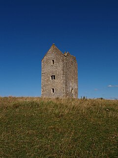
The Bruton Dovecote is a limestone tower that was built between the 15th and 17th century in Bruton in the English county of Somerset. The structure was once used as a dovecote, and may have been a watchtower or prospect tower prior to this. It is a Grade II* listed building and scheduled monument.

Landacre Bridge carries Landacre Lane across the River Barle near Withypool on Exmoor in the English county of Somerset. It has been scheduled as an ancient monument and Grade II* listed building.
