Related Research Articles
An optical telegraph is a line of stations, typically towers, for the purpose of conveying textual information by means of visual signals. There are two main types of such systems; the semaphore telegraph which uses pivoted indicator arms and conveys information according to the direction the indicators point, and the shutter telegraph which uses panels that can be rotated to block or pass the light from the sky behind to convey information.

Hindhead is a village in Surrey, England. It is the highest village in Surrey, with buildings at between 185 and 253 metres above sea level. It is best known as the location of the Devil's Punch Bowl, a beauty spot and site of special scientific interest, and as the site of the Hindhead crossroads, a formerly notorious congestion spot, where the A3 between Portsmouth and London was crossed by the A287 between Hook and Haslemere. The A3 now passes under Hindhead in the Hindhead Tunnel and its route along the Punch Bowl has been removed and landscaped, but the crossroads still exists for local traffic.
East Horsley is a village and civil parish in Surrey, England, 21 miles southwest of London, on the A246 between Leatherhead and Guildford. Horsley and Effingham Junction railway stations are on the New Guildford line to London Waterloo. The two-halves of ancient Horsley are similar in having substantial woodland and some chalky lower slopes, in the south, of the North Downs.
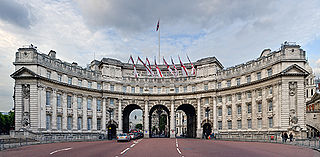
Admiralty Arch is a landmark building in London providing road and pedestrian access between The Mall, which extends to the southwest, and Trafalgar Square to the northeast. Admiralty Arch, commissioned by King Edward VII in memory of his mother, Queen Victoria, and designed by Aston Webb, is now a Grade I listed building. In the past, it served as residence of the First Sea Lord and was used by the Admiralty. Until 2011, the building housed government offices. In 2012, the government sold the building on a 125-year lease for £60m for a proposed redevelopment into a Waldorf Astoria luxury hotel and four apartments.

Haslemere is a town in the borough of Waverley in Surrey, England. It is north-east of the tripoint with Hampshire and West Sussex, approximately 12 miles (19 km) southwest of Guildford, and is the most southerly town in Surrey. The town is in the upper Wey valley and east of the A3, the major road between London and Portsmouth.
Witley is a village and civil parish in the Borough of Waverley in Surrey, England centred 2.6 miles (4 km) south west of the town of Godalming and 6.6 miles (11 km) southwest of the county town, Guildford. The land is made up of mixed rural and suburban areas.

Coombe is a historic neighbourhood in the Royal Borough of Kingston upon Thames in London, England. As the name implies it sits on high ground, east of the Norbiton area of Kingston upon Thames. The neighbourhood as to its southern bulk or entirety, depending on how Kingston Hill is defined, was part of the former Municipal Borough of Malden and Coombe before local government re-organisation in 1965. It now shares borders with the boroughs of Merton and Sutton with two others almost neighbouring; to the north are the small, inter-related neighbourhoods of Kingston Hill and Kingston Vale beyond which is Richmond Park in Richmond and Roehampton/Putney Vale in Wandsworth. To the east are public playing fields for hire and club use and Wimbledon Common.

Claygate is a suburban village in Surrey, England, 13 miles south-west of central London. It is the only civil parish in the borough of Elmbridge. Surrounded by green belt, it lies outside the Greater London Built-up Area.

Binsted is a village and large civil parish in the East Hampshire district of Hampshire, England. It lies about 4.1 miles (6.6 km) east of Alton, its nearest town. The parish is one of the largest in northern Hampshire and covers almost 7,000 acres (2,800 ha). It contains two villages, Bucks Horn Oak and Holt Pound, as well as two hamlets, Wyck and Wheatley. The parish also covers the entirety of the Alice Holt Forest, a royal forest situated near the border with Surrey. The nearest railway station is 1.8 miles (2.9 km) northeast of the village, at Bentley. According to the 2011 census, the parish had a population of 1,817 people.

The Deal Timeball is a Victorian maritime Greenwich Mean Time signal located on the roof of a waterfront four-storey tower in the coastal town of Deal, in Kent, England. It was established in 1855 by the Astronomer Royal George Biddell Airy in collaboration with Charles V. Walker, superintendent of telegraphs for the South Eastern Railway Company. It was built by the Lambeth firm of engineers Maudslay and Field. The time ball, which, like the Greenwich time ball, fell at 1 pm precisely, and was triggered by an electric signal directly from the Royal Observatory.
Fawkham is a village and civil parish in the Sevenoaks District of Kent, England. Fawkham is defined as a hamlet by Sevenoaks District Council, with a population of 429. Fawkham is a low density, linear settlement along the bottom of a dry chalk valley some three miles in length, with secondary lanes intersecting. There is no discernible village centre, although clusters of buildings occur near the Church/junction with Castle Hill, and around the village green and public house at the junction with Fawkham Green Road. There are around 220 houses.

Whitwell and Reepham railway station, also known as Whitwell station, is a former station situated in Norfolk, England. The station closed in 1959 and is a notable stop on the Marriott's Way long-distance footpath. It is being restored as a railway museum, including the re-laying of track.

The Greensand Ridge is an extensive, prominent, often wooded, mixed greensand/sandstone escarpment in south-east England. It runs to and from the East Sussex coast, around the Weald, a former dense forest in Sussex, Surrey and Kent. It reaches its highest elevation, 294 metres (965 ft), at Leith Hill in Surrey—the second highest point in south-east England, while another hill in its range, Blackdown, is the highest point in Sussex at 280 metres (919 ft). The eastern end of the ridge forms the northern boundary of Romney Marsh.

Malden Rushett is a small village in the Royal Borough of Kingston upon Thames, London. It is located at the southernmost tip of the Royal Borough, surrounded by woodland and farmland, and between the larger suburban villages and towns of Claygate, Chessington, Epsom, Ashtead, Leatherhead and Oxshott.

HMS Mercury was a shore establishment of the Royal Navy, and the site of the Royal Navy Signals School and Combined Signals School. There was also a subsidiary branch, HMS Mercury II.

Chatley Heath is part of 336 hectare reserve including Wisley Common, Ockham and parts of Hatchford. It is an area with a mixed habitats including heathland, ancient woodland and conifer woodland. On the top of Chatley heath is a tower built as part of the Royal Navy Semaphore line.

Hascombe Hill or Hascombe Camp is the site of an Iron Age multivallate hill fort close to the village of Hascombe in Surrey, England.

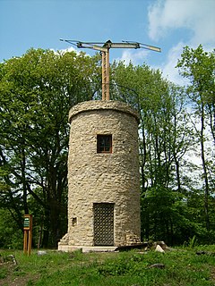
Pewley Hill is a hill, and a street so named, near Guildford in England. It links to the open space at Pewley Down and was used as the site of a semaphore station and a defensive fort in the nineteenth century. In the late 19th and early 20th centuries much of the land was built upon.
Camp Down is a location at Portsdown Hill, Hampshire, which was used as an Admiralty semaphore station and later as a redoubt on the line of Palmerston Forts, Portsmouth.

Compton Down is an extent of high ground near Compton, West Sussex where there was an Admiralty semaphore station.
References
| Next station upwards | Admiralty Semaphore line 1822 | Next station downwards |
| Bannicle Hill | Haste Hill | Holder Hill |
Coordinates: 51°04′56″N0°42′04″W / 51.0822°N 0.7012°W
| This Surrey location article is a stub. You can help Wikipedia by expanding it. |