
Etne is a municipality in Hordaland county, Norway. It is located in the traditional district of Sunnhordland, although it is also sometimes considered to be part of the district of Haugaland. The administrative centre of the municipality is the village of Etnesjøen. Other villages in the municipality include Skånevik and Fjæra. The two largest villages in the municipality are Etnesjøen with 1,159 residents and Skånevik with 594 residents.

Jondal is a municipality in Hordaland county, Norway. It is located on the Folgefonna peninsula in the Hardanger district, on the eastern shore of the Hardangerfjorden. The administrative centre of the municipality is the village of Jondal. Other villages in Jondal include Herand, Kysnesstranda, and Torsnes.
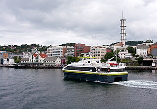
Leirvik is a town and the administrative centre of Stord municipality in Hordaland county, Norway. The town lies along the southern coast of the large island of Stord, along the Hardangerfjorden. The town gained "town status" in 1997. The town includes the Eldøyane peninsula where the large Kværner Stord industrial area is located.

Rosendal is the administrative centre of the municipality of Kvinnherad in Hordaland county, Norway. The village is located on the southern shore of the Hardangerfjorden, about 4 kilometres (2.5 mi) north of the village of Dimmelsvik and about 10 kilometres (6.2 mi) straight west of the vast Folgefonna glacier which sits inside the nearby Folgefonna National Park. The village is especially known for the Barony Rosendal, a historic estate located in the village. Kvinnherad Church is also located in this village.
Onarheimsvatnet or Opsangervatnet is a lake in the municipality of Kvinnherad in Hordaland county, Norway. The 2.25-square-kilometre (0.87 sq mi) lake is located between the villages of Husnes and Sunde.

Fjelberg is a former municipality in Hordaland county, Norway. The municipality existed from 1838 until 1965 when it was dissolved. In 1965, the municipality covered 79.8 square kilometres (30.8 sq mi), mostly islands and a small area on the mainland. It encompassed part of the present day municipalities of Kvinnherad and Vindafjord, primarily the islands of Fjelbergøya, Borgundøya, and Halsnøya, as well as some surrounding areas on the mainland. The administrative centre of the municipality was the small village located on the island of Fjelbergøya where Fjelberg Church is located.

Sagvåg is a village in Stord municipality in Hordaland county, Norway. The village is located on the southwest coast of the island of Stord, about 5 kilometres (3.1 mi) west of the town of Leirvik. The Stord Airport, Sørstokken lies about 2 kilometres (1.2 mi) northwest of Sagvåg. Nysæter Church was built here in 1991 to serve the population of the village. The small mining village of Litlabø lies just northeast of Sagvåg.

Gjetingsdalen is a village in the Mauranger area of Kvinnherad municipality in Hordaland county, Norway. The village is located in the Gjetingsdalen valley, on a hillside overlooking the Maurangsfjorden. The village of Austrepollen lies about 5 kilometres (3.1 mi) to the east, across the fjord. There is only one road leading into and out of the village, making it rather isolated, but its close proximity to the Jondal Tunnel and Folgefonna Tunnel, give it good access to nearby urban areas. There is a hydroelectric power plant located along the river which runs through this valley.

Husnes is the largest village in Kvinnherad municipality in Hordaland county, Norway. The village is located on the southern shore of the Hardangerfjorden on the Folgefonna peninsula, about 8 kilometres (5.0 mi) south of the village of Herøysund and immediately north of the villages of Sunde and Valen. The lake Onarheimsvatnet lies along the southwestern part of the village between Husnes and Sunde.
Valen is a village in Kvinnherad municipality in Hordaland county, Norway. The village is located on the mainland coast overlooking the island of Halsnøy to the south. The undersea Halsnøy Tunnel connects Halsnøy island to the mainland just to the west of Valen, in the neighboring village of Sunde.
Uskedal or Uskedalen is a village in Kvinnherad municipality in Hordaland county, Norway. The village is located in a small valley along the southern shore of the Hardangerfjorden, about 7 kilometres (4.3 mi) southwest of the village of Dimmelsvik and about 4 kilometres (2.5 mi) east of the village of Herøysund.

Våge is the largest village in Tysnes municipality in Hordaland county, Norway. The village is located on the northern shore of the island of Tysnesøya, about 4 kilometres (2.5 mi) north of the municipal centre of Uggdal. The 1.03-square-kilometre (250-acre) village has a population (2015) of 690, giving the village a population density of 663 inhabitants per square kilometre (1,720/sq mi). The village is the site of Tysnes Church. The village has a ferry quay that has regular connections to Haljem on the mainland of Os municipality on the other side of the Bjørnafjorden.
Skånevik is a village in Etne municipality in Hordaland county, Norway. The village is located along the Skånevikfjorden, near the entrance to the Åkrafjorden. The village lies across the fjord from the village of Utåker in neighboring Kvinnherad municipality. The municipal centre of Etnesjøen lies about 8 kilometres (5.0 mi) straight south across a mountain, although one must drive about 22 kilometres (14 mi) around the mountain to get there.

Sæbøvik is a village in Kvinnherad municipality in Hordaland county, Norway. The village is located on the narrow, western part of the island of Halsnøya, about 6 kilometres (3.7 mi) west of the village of Høylandsbygd and immediately east of the village of Eidsvik. The village is located at the southern end of the Halsnøy Tunnel.
Eidsvik is a village in Kvinnherad municipality in Hordaland county, Norway. The village is located on the northwestern end of the island of Halsnøya, just west of the village of Sæbøvik. The village lies on a thin, narrow isthmus-like peninsula sticking out into the Hardangerfjorden.
Sunde is a village in Kvinnherad municipality in Hordaland county, Norway. The village is located along the Hardangerfjorden, just north of the island of Halsnøya. The northern entrance to the Halsnøy Tunnel is located in Sunde. The large urban village of Husnes lies just to the north of Sunde, on the other end of the lake Onarheimsvatnet.
Dimmelsvik is a village in Kvinnherad municipality in Hordaland county, Norway. The village is located on the south shore of the Hardangerfjorden, about 4 kilometres (2.5 mi) south of the municipal centre of Rosendal and about 7 kilometres (4.3 mi) northeast of the village of Uskedal.
Herøysund is a village in Kvinnherad municipality in Hordaland county, Norway. The village is located on the southeastern shore of the Hardangerfjorden, about half-way between the villages of Husnes and Uskedal. The 0.48-square-kilometre (120-acre) village has a population (2013) of 486, giving the village a population density of 1,013 inhabitants per square kilometre (2,620/sq mi).

Hatlestrand Church is a parish church in Kvinnherad municipality in Hordaland county, Norway. It is located in the village of Hatlestrand. The church is part of the Hatlestrand parish in the Sunnhordland deanery in the Diocese of Bjørgvin. The church was built in 1885 by the architects Conrad Fredrik von der Lippe and Kjartan Imsland. The white, wooden church seats about 140 people.


