
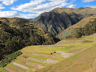
Espinar Province is one of thirteen provinces in the Cusco Region in the southern highlands of Peru.
Ocoruro or Uqururu is one of eight districts of the Espinar Province in Peru.
Suykutambo District is one of eight districts of the Espinar Province in Peru.
Kanamarka or Kanamarca is an archaeological site in Peru. It is located in the Cusco Region, Espinar Province, Alto Pichigua District.
Kunturqucha is a lake in Peru located in the Ayacucho Region, Paucar del Sara Sara Province, Oyolo District. It lies southwest of the lakes Tipiqucha, Huch'uy Tipiqucha, Hatun Tipiqucha and Chawpi Tipiqucha, and east of the lake Yanaqucha.
Quriwayrachina, Quri Wayrachina, Hatun Quriwayrachina or Hatun Quri Wayrachina is an archaeological site of the Inca period in Peru located in the Ayacucho Region, Lucanas Province, Carmen Salcedo District. It lies near the mountain Inka Pallanka which is venerated as an apu by the people of the area. There are two platforms which are known as Hatun Quri Wayrachina and Huch'uy Quri Wayrachina by the locals. On April 20, 2011, the site was declared a National Cultural Heritage by Resolución Viceministerial No. 459-2011-VMPCIC-MC.

Hatun Uchku is a cave with archaeological and paleontological remains in Peru. It was declared a National Cultural Heritage by Resolución Directoral No. 441/INC on May 23, 2002. Hatun Uchku is situated in the Huánuco Region, Ambo Province, Ambo District, about 500 m south of the main square of Ambo, at a height of 2,206 metres (7,238 ft).
Hatun Machay is a rock forest with archaeological remains in Peru. It was declared a National Cultural Heritage by Resolución Directoral No. 944/INC-2010 on May 7, 2010. Hatun Mach'ay is situated on the western side of the Cordillera Negra in the Ancash Region, Recuay Province, Pampas Chico District, at a height of about 4,200 metres (13,780 ft).
Hatunmarka is an archaeological site in Peru. It is located in the Junín Region, Jauja Province, Marco District. The site was declared a National Cultural Heritage by Resolución Directoral Nacional No. 1346 in November 2000.
Hatun Luychu is a mountain in the Andes of Peru, about 4,400 metres (14,436 ft) high. It lies in the Cusco Region, Urubamba Province, on the border of the districts of Chinchero and Hayllabamba, northeast of Chinchero. The mountain southeast of Hatun Luychu is named Wallata Wachana
Hatun Qillqa is a mountain in the Wansu mountain range in the Andes of Peru, about 5,000 metres (16,404 ft) high. It is situated in the Apurímac Region, Antabamba Province, Antabamba District. Hatun Qillqa lies southeast of Qillqa, southwest of Sisiwa and Yuraq Urqu and northwest of Wank'ayuq Saywa.
Hatun Ch'aqu is a mountain in the Andes of Peru, about 5,000 metres (16,404 ft) high. It is located in the Cusco Region, Canchis Province, Pitumarca District, and in the Quispicanchi Province, Cusipata District. It lies south-west of the mountain Ch'aqu, west of the mountain Yanaqaqa, north-west of the mountain Tiklla Q'asa and north of the mountain Tuqtu. Its ridge stretches to the north-west.
Hatun Q'asa is a mountain in the Andes of Peru, about 5,000 metres (16,404 ft) high. It is situated in the Apurímac Region, Antabamba Province, Oropesa District. It lies south of Mallmanya, northwest of Sura Kallanka and southeast of Kimsaqucha. East of Hatun Q'asa there is a lake named Suraqucha (Soracocha).
Hatun Sisiwa is a 5,003-metre-high (16,414 ft) mountain in the Wansu mountain range in the Andes of Peru. It is situated in the Arequipa Region, La Unión Province, Huaynacotas District. Hatun Sisiwa lies northeast of Sullu Marka.
Hatun Rit'i is a mountain in the Andes of Peru, about 4,800 metres (15,748 ft) high. It lies in the Huancavelica Region, Angaraes Province, Lircay District.
Hatun Usnu is an archaeological site in Peru on a mountain of the same name (Jatunhosno). It is located in the Ayacucho Region, Huamanga Province, Chiara District.
Hatun Misapata or Misapata is an archaeological site in the Ayacucho Region in Peru. It was declared a National Cultural Heritage by Resolución Viceministerial Nº 459-2011-VMPCIC-MC of April 20, 2011. Hatun Misapata is situated in the Lucanas Province, Aucara District.
Hatun Pukara is a mountain in the Andes of Peru, about 4,000 metres (13,123 ft) high. It is located in the Cusco Region, Calca Province, on the border of the districts of Coya and Taray, southwest of Taray. It lies south of the Willkanuta River.
Wanu Wanu is a mountain in the Andes of Peru, about 4,800 m (15,700 ft) high. It is located in the Cusco Region, Espinar Province, on the border of the districts of Condoroma and Ocoruro. It lies northeast of Atawallpa and southeast of Hatun Chhuka.
Hatun Kunka is a mountain in the Cordillera Negra in the Andes of Peru which reaches a height of approximately 4,400 m (14,436 ft). It is located in the Ancash Region, Huaylas Province, Pamparomas District, and in the Yungay Province, Quillo District.


