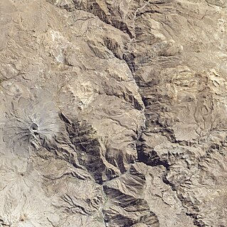
The General Sánchez Cerro Province is the smallest of three provinces in the Moquegua Region of Peru. The capital of the province is Omate. The province was named after the former Peruvian army officer and president Luis Miguel Sánchez Cerro.

Ichuña District is one of eleven districts of the General Sánchez Cerro Province in Peru.

Chojata District is one of eleven districts of the General Sánchez Cerro Province in Peru.
Matalaque District is one of eleven districts of the General Sánchez Cerro Province in Peru.

Ubinas District is one of eleven districts of the province General Sánchez Cerro in the Moquegua Region in Peru.
Jatun Mayu or Hatun Mayu may refer to:

Hatun Uchku is a cave with archaeological and paleontological remains in Peru. It was declared a National Cultural Heritage by Resolución Directoral No. 441/INC on May 23, 2002. Hatun Uchku is situated in the Huánuco Region, Ambo Province, Ambo District, about 500 m south of the main square of Ambo, at a height of 2,206 metres (7,238 ft).
Hatunmarka is an archaeological site in Peru. It is located in the Junín Region, Jauja Province, Marco District. The site was declared a National Cultural Heritage by Resolución Directoral Nacional No. 1346 in November 2000.
Jatun Q'asa or Hatun Q'asa may refer to:

Pachakutiq is a 5,173-metre-high (16,972 ft) mountain in the Andes of Peru. It is located southeast of Lake Salinas in the Arequipa Region, Arequipa Province, Tarucani District, and in the Moquegua Region, General Sánchez Cerro Province, Coalaque District. Pachakutiq lies northwest of Q'uwa Laki and Qillqata.

Pacoorcco erroneously also Poocoorco, is a 4,940-metre-high (16,207 ft) mountain in the Andes of Peru. The mountain is located in the Moquegua Region, General Sánchez Cerro Province, Ubinas District, north-east of the active volcano Ubinas and south of the mountain Pirhuane.
Hatun Urqu or Jatun Urqu may refer to:

Jatun Punta is a mountain in the Vilcanota mountain range in the Andes of Peru, about 5,200 metres (17,060 ft) high. It is situated in the Cusco Region, Quispicanchi Province, Ocongate District. Jatun Punta lies southwest of Callangate and west Puca Punta.

Hatun Pata is a 5,182-metre (17,001 ft) mountain in the Chunta mountain range in the Andes of Peru. It is located in the Huancavelica Region, Huancavelica Province, Ascensión District. Hatun Pata lies northwest of Pinqullu and northeast of Pata Pata. The river Kachimayu originates south of the mountain. It flows to the northeast as a tributary of Ichhu River.

Hatun Sisiwa is a 5,003-metre-high (16,414 ft) mountain in the Wansu mountain range in the Andes of Peru. It is situated in the Arequipa Region, La Unión Province, Huaynacotas District. Hatun Sisiwa lies northeast of Sullu Marka.

Nina Ukru is a mountain in the Paryaqaqa or Waruchiri mountain range in the Andes of Peru, about 5,400 metres (17,717 ft) high. It is situated in the Lima Region, Huarochirí Province, Quinti District. Nina Ukru lies southwest of Qullqip'ukru and west of Paryaqaqa.

Hatun Ukru is a mountain in the Cordillera Central in the Andes of Peru, about 4,800 m (15,748 ft) high. It is situated in the Lima Region, Huarochirí Province, Quinti District. Hatun Ukru lies southwest of a lake named P'itiqucha.

Jatun Huiscana is a mountain in the Urubamba mountain range in the Andes of Peru, about 4,600 metres (15,092 ft) high. It lies in the Cusco Region, Calca Province, Lares District. Jatun Huiscana is situated northwest of Ccerayoc and Yanaorcco, and northeast of Sahuasiray.

P'ukru is a mountain in the Andes of Peru, about 5,050 m (16,570 ft) high. It is located in the Lima Region, Cajatambo Province, Gorgor District, and in the Oyón Province, Oyón District.

Hatun Ukru is a 4,650-metre-high (15,260 ft) mountain in the Andes of Peru. It is located in the Pasco Region, Pasco Province, Ticlacayan District, northwest of the Waqurunchu mountain range.


