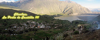
Matalaque | |
---|---|
District | |
Country | |
Region | Moquegua |
Province | General Sánchez Cerro |
Founded | August 28, 1920 |
Capital | Matalaque |
Government | |
• Mayor | Marcos Coaquira Felipe |
Area | |
• Total | 557.23 km2 (215.15 sq mi) |
Elevation | 2,538 m (8,327 ft) |
Population (2005 census) | |
• Total | 1,430 |
• Density | 2.6/km2 (6.6/sq mi) |
Time zone | PET (UTC-5) |
UBIGEO | 180207 |
Matalaque District is one of eleven districts of the General Sánchez Cerro Province in Peru. [1]
The districts of Peru are the third-level country subdivisions of Peru. They are subdivisions of the provinces, which in turn are subdivisions of the larger regions or departments. There are 1,838 districts in total.
The General Sánchez Cerro Province is the smallest of three provinces in the Moquegua Region of Peru. The capital of the province is Omate. The province was named after the former Peruvian army officer and president Luis Miguel Sánchez Cerro.
Peru, officially the Republic of Peru, is a country in western South America. It is bordered in the north by Ecuador and Colombia, in the east by Brazil, in the southeast by Bolivia, in the south by Chile, and in the west by the Pacific Ocean. Peru is a megadiverse country with habitats ranging from the arid plains of the Pacific coastal region in the west to the peaks of the Andes mountains vertically extending from the north to the southeast of the country to the tropical Amazon Basin rainforest in the east with the Amazon river.
One of the highest peaks of the district is Puka Saya at approximately 5,320 m (17,450 ft). Other mountains are listed below: [2]
Hatun P'ukru is a mountain in the Andes of southern Peru, about 5,153-metre (16,906 ft) high. It is situated in the Moquegua Region, General Sánchez Cerro Province, on the border of the districts of Chojata and Matalaque.
Qullpani is a mountain in the Andes of Peru which reaches a height of approximately 4,800 m (15,700 ft). It is located in the Arequipa Region, Arequipa Province, Tarucani District, and in the Moquegua Region, General Sánchez Cerro Province, Matalaque District. Qullpani lies southwest of the Ubinas volcano.
Q'uwa Laki is a mountain in the Andes of Peru, about 5,200 metres (17,060 ft) high. It is located in the Moquegua Region, General Sánchez Cerro Province, on the border of the districts Coalaque, Matalaque and Omate. Q'uwa Laki lies southeast of the peaks of Qillqata and Wilani.
Melgar Province is a province of the Puno Region in Peru. The capital of the province is the city of Ayaviri.
Lloque District is one of eleven districts of the province General Sánchez Cerro in Peru.
Ichuña District is one of eleven districts of the General Sánchez Cerro Province in Peru.
Coalaque District is one of eleven districts of the General Sánchez Cerro Province in Peru.
Chojata District is one of eleven districts of the General Sánchez Cerro Province in Peru.
Omate District is one of eleven districts of the province General Sánchez Cerro in Peru.
Puquina District is one of eleven districts of the General Sánchez Cerro Province in Peru.
Quinistaquillas District is one of eleven districts of the province General Sánchez Cerro in Peru.
Ubinas District is one of eleven districts of the province General Sánchez Cerro in the Moquegua Region in Peru.
Yunga District is one of eleven districts of the province General Sánchez Cerro in Peru.
Ituata District is one of ten districts of the Carabaya Province in Peru.
Ollachea District is one of ten districts of the province Carabaya in Peru.
Santa Lucía District is one of ten districts of the province Lampa in Peru.
Nuñoa District is one of nine districts of the Melgar Province in Peru.
Checacupe or Ch'iqa Kupi is one of eight districts of the Canchis Province in the Cusco Region in Peru.
Pitumarca District is one of eight districts of the province Canchis in Peru.
San Juan de Tarucani District is one of 29 districts of the province Arequipa in Peru.
Chachas District is one of fourteen districts of the province Castilla in Peru.
Lircay District is one of twelve districts of the Angaraes Province in Peru.
This Moquegua Region geography article is a stub. You can help Wikipedia by expanding it. |
Coordinates: 16°28′55″S70°49′34″W / 16.4820°S 70.8262°W
A geographic coordinate system is a coordinate system that enables every location on Earth to be specified by a set of numbers, letters or symbols. The coordinates are often chosen such that one of the numbers represents a vertical position and two or three of the numbers represent a horizontal position; alternatively, a geographic position may be expressed in a combined three-dimensional Cartesian vector. A common choice of coordinates is latitude, longitude and elevation. To specify a location on a plane requires a map projection.