Coalaque District

Last updated • a couple of secsFrom Wikipedia, The Free Encyclopedia
Coalaque
Bandera de Coalaque.png
Flag of Coalaque
Country Flag of Peru.svg  Peru
Region Moquegua
Province General Sánchez Cerro
FoundedJanuary 26, 1956
Capital Coalaque
Government
   Mayor Raul Rey Arambulo Alvarez
Area
  Total247.58 km2 (95.59 sq mi)
Elevation
2,283 m (7,490 ft)
Population
  Total1,595
  Density6.4/km2 (17/sq mi)
Time zone UTC-5 (PET)
UBIGEO 180203

Coalaque District is one of eleven districts of the General Sánchez Cerro Province in Peru. [1]

Geography

One of the highest peaks of the district is Qillqata at approximately 5,200 m (17,100 ft). Other mountains are listed below: [2]

Related Research Articles

<span class="mw-page-title-main">Tiabaya District</span> District in Arequipa, Peru

Tiabaya District is one of the twenty-nine districts of the Arequipa Province in Peru.

Querecotillo District is one of eight districts of the province Sullana in Peru.

San Pedro District is one of eight districts of the province Canchis in Peru.

<span class="mw-page-title-main">Santiago District, Cusco</span> District in Cusco, Peru

Santiago District is one of eight districts of the Cusco Province in Peru.

Wanchaq District is one of eight districts of the province Cusco in Peru. It includes Avenida de la Cultura, and Avenida de los Incas. It is home to 2 hospitals, and borders the district of San Sebastian.

Pichigua District is one of eight districts of the Espinar Province in Peru.

<span class="mw-page-title-main">La Joya District</span> District in Arequipa, Peru

La Joya District is one of twenty-nine districts of the province Arequipa in Peru.

Mollebaya District is one of twenty-nine districts of the province Arequipa in Peru.

Pocsi District is one of twenty-nine districts of the province of Arequipa in Peru.

<span class="mw-page-title-main">Polobaya District</span> District in Arequipa, Peru

Polobaya District is one of twenty-nine districts of the province Arequipa in Peru. The village of Chapi with the sanctuary of Our Lady of Chapi is located in this district.

<span class="mw-page-title-main">Quequeña District</span> District in Arequipa, Peru

Quequeña District is one of twenty-nine districts of the province of Arequipa in Peru.

<span class="mw-page-title-main">Sachaca District</span> District in Arequipa, Peru

Sachaca District is one of twenty-nine districts of the province Arequipa in Peru.

<span class="mw-page-title-main">Uchumayo District</span> District in Arequipa, Peru

Uchumayo or Uchumayu is one of twenty-nine districts of the province Arequipa in Peru.

<span class="mw-page-title-main">Vitor District</span> District in Arequipa, Peru

Vitor District is one of twenty-nine districts of the province Arequipa in Peru.

Yarabamba District is one of twenty-nine districts of the province Arequipa in Peru.

Yura District is one of twenty-nine districts of the Arequipa Province in Peru.

<span class="mw-page-title-main">Chivay District</span> District in Arequipa, Peru

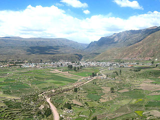
Chivay District is one of twenty districts of the province Caylloma in Peru.

Huanca District is one of twenty districts of the province Caylloma in Peru. 1450 people live in Huanca District to status data as June 30, 2015.

<span class="mw-page-title-main">Lari District</span> District in Arequipa, Peru

Lari District is one of twenty districts of the province Caylloma in Peru.

<span class="mw-page-title-main">Chavín de Huantar District</span> District in Ancash, Peru

Chavín de Huántar District is one of sixteen districts of the Huari Province in Peru.

References

  1. (in Spanish) Instituto Nacional de Estadística e Informática. Banco de Información Distrital Archived April 23, 2008, at the Wayback Machine . Retrieved April 11, 2008.
  2. escale.minedu.gob.pe/ UGEL map Mariscal Nieto Province (Moquegua Region)

16°38′56″S71°01′15″W / 16.6490°S 71.0209°W / -16.6490; -71.0209