Related Research Articles
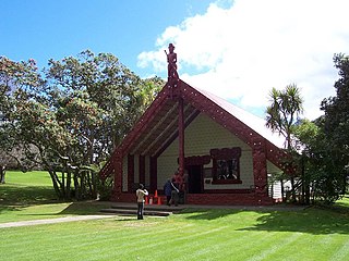
Waitangi is a locality on the north side of the Waitangi River in the Bay of Islands, 60 kilometres north of Whangarei, on the North Island of New Zealand. It is close to the town of Paihia, to which it is connected by a bridge near the mouth of the Waitangi River estuary. While Statistics New Zealand and NZ Post consider the southern boundary of Waitangi to be the river and estuary, with the area further south being part of Paihia, the area by Te Tī Bay, immediately south of the river, is sometimes referred to as part of Waitangi.

Moturoa / Rabbit Island is a small island that lies across the southernmost part of Tasman Bay / Te Tai-o-Aorere, on the northern coast of New Zealand's South Island. The long narrow island runs east–west for 8 kilometres (5 mi), and covers 15 km2 (5.8 sq mi).
Johann Karl Ernst Dieffenbach, also known as Ernest Dieffenbach, was a German physician, geologist and naturalist, the first trained scientist to live and work in New Zealand, where he travelled widely under the auspices of the New Zealand Company, returning in 1841–42 and publishing in English his Travels in New Zealand in 1843.

Paihia is the main tourist town in the Bay of Islands in the Northland Region of the North Island of New Zealand. It is 60 kilometres north of Whangārei, located close to the historic towns of Russell and Kerikeri. Missionary Henry Williams named the mission station Marsden's Vale. Paihia eventually became the accepted name of the settlement.

Te Haumi is a settlement south-east of Paihia and north-west of Opua in the Bay of Islands area of Northland Region, New Zealand.

The Hātea River is a river of New Zealand. It flows from the north-east of Whangarei southwards and into the northern head of Whangarei Harbour. Its lower length forms the eastern boundary of the city. The banks along the lower reaches are parks and bushland with a series of metalled walks suitable for all weathers.
The Hikurangi River is a river of Northland, New Zealand. A winding stretch of river, it can be considered an extension of the Kaikou River, being formed from the confluence of this river and the Moengawahine Stream. The Hikurangi flows south past the Pipiwai settlement for several kilometres before flowing into the Mangakahia River, 25 kilometres (16 mi) west of Whangarei.
The Karukaru River is a river of New Zealand. A tributary of the Wairua River, it rises west of Maungatapere and flows westward into that river south of Titoki.

The Kawakawa River is in the Northland Region of New Zealand's North Island. It flows predominantly eastward to Opua, where it joins the Waikare Inlet to flow into the Veronica Channel at the southern end of the Bay of Islands.
The Manawapou River is a river of the Taranaki Region of New Zealand's North Island. It flows southwest, from its origins in rough hill country to the northeast of Hāwera, to reach the South Taranaki Bight between Hāwera and Patea.
The Mangakahia River is a river of the Northland Region of New Zealand's North Island. It flows east from its sources in the Mataraua Forest, turning southeastward after about 20 kilometres (12 mi) on joining with the small Awarua River. It is joined by the Opouteke River near Pakotai, then turns east, until it is joined by the Hikurangi River. It then turns south again, passing Titoki and then joining with the Wairua River to form the Wairoa River approximately halfway between Whangarei and Dargaville.
The Mangapai River is a river of the Northland Region of New Zealand's North Island. It is perhaps better described as a silty arm of Whangarei Harbour, located 10 kilometres (6 mi) due south of Whangarei. Its average width is some 4 metres (13 ft), but the silty nature of its course means that the stream itself is far narrower.
The Māngere River is a river of the Northland Region of New Zealand's North Island. It flows generally westwards from its sources in hills northwest of Whangarei, meeting the Wairua River 10 kilometres (6 mi) northwest of Maungatapere.
The Ngunguru River is a river of the Northland Region of New Zealand's North Island. It initially flows southwest before turning east to flow into a long, wide estuary which empties into Ngunguru Bay to the northwest of Whangārei. The town of Ngunguru sits on the estuary's north bank at its opening to the bay.

The Ruakākā River is a river of the Northland Region of New Zealand's North Island. It flows north before turning east and finally south, reaching the sea at the township of Ruakākā on Bream Bay.

The Waingongoro River is a river of the Taranaki Region of New Zealand's North Island. It flows initially southeast from the slopes of Taranaki/Mount Egmont and passes through the town of Eltham before veering southwest to meet the Tasman Sea five kilometres west of Hawera, at Ohawe Beach.
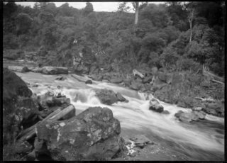
The Wairua River is a river of Northland, New Zealand. It flows south-west from Hikurangi and joins the Mangakahia River between Titoki and Tangiteroria to form the Wairoa River, which runs past Dargaville to the Kaipara Harbour.
The Whakapara River is a river of the Northland Region of New Zealand's North Island. One of the headwaters of the Wairua River, it flows generally east from its sources close to the North Auckland Peninsula's east coast, and reaches the Wairua 5 km (3.1 mi) west of Otonga.

The Waitangi River is a river of the Northland Region of New Zealand's North Island. It originates close to the northern shore of Lake Ōmāpere and flows eastwards to the Bay of Islands. It is considered to end either where it drops over Haruru Falls into a tidal estuary, or where the estuary opens into Te Tī Bay, just below the bridge between the historic locality of Waitangi and the town of Paihia.

Mair Park is in Whangārei, New Zealand, adjacent to the suburb of Mairtown. It is named for Robert Mair, who donated the land from his estate to the city in 1914. The park includes access to the Hātea River. Access to the park is off Rurumoki Street.
References
- ↑ "Place name detail: Haumi River". New Zealand Gazetteer. New Zealand Geographic Board . Retrieved 7 March 2023.
Coordinates: 35°17′53″S174°05′58″E / 35.298031°S 174.099531°E