
The Havel is a river in north-eastern Germany, flowing through the German states of Mecklenburg-Vorpommern, Brandenburg, Berlin and Saxony-Anhalt. It is a right tributary of the Elbe and 325 kilometres (202 mi) long. However, the direct distance from its source to its mouth is only 94 kilometres (58 mi).

Havelland is a district or county in Brandenburg, Germany. It is bounded by the districts of Ostprignitz-Ruppin and Oberhavel, the city-state of Berlin, the district of Potsdam-Mittelmark, the city of Brandenburg and the state of Saxony-Anhalt.

Nauen is a small town in the Havelland district, in Brandenburg, Germany. It is chiefly known for Nauen Transmitter Station, the world's oldest preserved radio transmitting installation.

Bundesautobahn 10 is an orbital motorway around the German capital city of Berlin. Colloquially called Berliner Ring, it is predominantly located in the state of Brandenburg, with a short stretch of 5 km in Berlin itself. It should not be confused with the Berliner Stadtring around Berlin's inner city.

The Province of Brandenburg was a province of Prussia from 1815 to 1945. Brandenburg was established in 1815 from the Kingdom of Prussia's core territory, comprised the bulk of the historic Margraviate of Brandenburg and the Lower Lusatia region, and became part of the German Empire in 1871. From 1918, Brandenburg was a province of the Free State of Prussia until it was dissolved in 1945 after World War II, and replaced with reduced territory as the State of Brandenburg in East Germany, which was later dissolved in 1952. Following the reunification of Germany in 1990, Brandenburg was re-established as a federal state of Germany, becoming one of the new states.
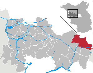
Rhinow is a town in the Havelland district (Landkreis), in Brandenburg, Germany. It is situated 16 km north of Rathenow, and 22 km south of Kyritz. Rhinow is the administrative seat (Verwaltungssitz) of the Rhinow district (Amt).
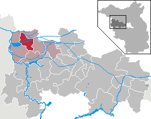
Schönwalde-Glien is a municipality in the Havelland district, in Brandenburg, Germany.

The Bezirk Potsdam was a district (Bezirk) of East Germany. The administrative seat and the main town was Potsdam.

Wustermark station is a railway station in the town of Wustermark in the Havelland region of the German state of Brandenburg, to the west of Berlin. The station is located on the Berlin–Lehrte railway and is connected with the Jüterbog–Nauen railway, part of which became part of the Berlin outer ring in the 1950s. It is classified by Deutsche Bahn as a category 5 station.

The Berlin/Brandenburg metropolitan region or capital region is one of eleven metropolitan regions of Germany, consisting of the entire territories of the state of Berlin and the surrounding state of Brandenburg. The region covers an area of 30,370 square kilometres (11,730 sq mi) with a total population of about 6 million.

Brandenburg an der Havel – Potsdam-Mittelmark I – Havelland III – Teltow-Fläming I is an electoral constituency represented in the Bundestag. It elects one member via first-past-the-post voting. Under the current constituency numbering system, it is designated as constituency 60. It is located in western Brandenburg, comprising the city of Brandenburg an der Havel, most of the Potsdam-Mittelmark district, and parts of the Havelland and Teltow-Fläming districts.

The Rhinluch is a fen landscape in the German state of Brandenburg, bisected by the river Rhin to which it owes its name. This wetland region lies north of Fehrbellin in the county of Ostprignitz-Ruppin. The upper Rhinluch covers an area of about 23,000 hectares. The suffix luch is used to describe several wet areas in the state of Brandenburg, in which, prior to the advent of modern drainage systems, water remained largely stagnant rather than flowing.
The Havelland Luch is a lowland area inside a bend of the River Havel west of Berlin, and forms the heart of the Havelland region.

Ländchen Friesack is a small ridge, up to 77 metres above sea level (NN). It is situated in Brandenburg, northwest of Germany's capital city, Berlin and southwest of the town of Friesack. The Ländchen extends for just under 5 kilometres in a north-south direction and separates the lowland and former marshes of the Rhinluch in the north from that of the Havelland Luch in the south. The upland is almost entirely forested. It is divided into the parishes of Friesack, Kleßen-Görne and Mühlenberge. Part of the Ländchen – around the lake of Görner See – is a nature reserve.
A Ländchen is the German name given to several Ice Age plateaux in the Havelland region, which climb to over 70 metres above the formerly marshy urstromtal levels of the Havelland Luch and the Rhinluch. The difference between these Ländchen and the surrounding countryside is even more marked because of the different land uses to which they are put. Extensive pastures in the lowlands contrast with the arable fields and woods on the low hills. Geologically they are largely complete formations of ground moraine from the Saale and Weichselian glaciations that, in places, are covered by gently rolling end moraines.

The Nauen Plateau is a low plateau in the German states of Brandenburg and Berlin. It rises above the surrounding countryside by an average of 15 metres (49 ft) and is a largely contiguous upland area that was formed during the Saale and Weichselian glaciations. It consists predominantly of ground moraine deposits, partly overlain by gently rolling end moraine formations. Whilst the neighbouring regions of Zauche to the south, the Teltow to the southeast and the Barnim to the northeast have the same name as their geological formation, the cultural landscape on the Nauen Plateau bears the historical and regional name of Havelland. That said, the river country of the Havelland extends beyond the plateau to include the Havel valley and other lowland areas.

Teltow [] is both a geological plateau and also a historical region in the German states of Brandenburg and Berlin. As an historical region, the Teltow was one of the eight territories out of which the March of Brandenburg was formed in the 12th and 13th centuries. As a result of the Teltow War (1239–1245) the question of territorial lordship of the newly created heart of the expanding march was finally decided here. Between 1835 and 1952 there was also a county, Teltow district; in addition a town immediately south of Berlin, in the present-day county of Potsdam-Mittelmark, bears the name Teltow.
The North Brandenburg Plateaux and Upland is a natural region in the northwest of Brandenburg and, to a lesser extent, the southwest of Mecklenburg-Vorpommern and northeast of Saxony-Anhalt in Germany. It is major unit group no. 77 in the natural regional divisions of Germany. The Brandenburg portion of the North Brandenburg Plateaux and Upland is largely coextensive with the natural region of Prignitz and Ruppin Land in the structural atlas of the state of Brandenburg.
The Central Brandenburg Plateaux and Lowlands form a natural region in the German state of Brandenburg and in parts of southwest Berlin and the east of Saxony-Anhalt. They are major unit group 81 in the system of natural regions of Germany and part of the East German Plateaux and Heathlands. The Brandenburg portion of the Central Brandenburg Plateaux and Lowlands is largely coincident with the natural region designated as the Central March in the structural atlas of the state of Brandenburg.


