
Hawthorne is an unincorporated community and census-designated place (CDP) in Mineral County, Nevada, United States. As of the 2020 census, the population was 3,118. It is the county seat of Mineral County. The nearby Hawthorne Army Depot is the primary economic base of the town.

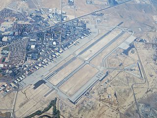
Tonopah is an unincorporated town in and the county seat of Nye County, Nevada, United States. Nicknamed the Queen of the Silver Camps for its mining-rich history, it is now primarily a tourism-based resort city, notable for attractions like the Mizpah Hotel and the Clown Motel.

The Nevada National Security Sites, popularized as the Nevada Test Site (NTS) until 2010, is a reservation of the United States Department of Energy located in the southeastern portion of Nye County, Nevada, about 65 mi (105 km) northwest of the city of Las Vegas.
Nellis Air Force Base is a United States Air Force installation in southern Nevada. Nellis hosts air combat exercises such as Exercise Red Flag and close air support exercises such as Green Flag-West flown in "Military Operations Area (MOA) airspace", associated with the nearby Nevada Test and Training Range (NTTR). The base also has the Combined Air and Space Operations Center-Nellis.

The Tonopah Test Range is a highly classified, restricted military installation of the United States Department of Defense, and United States Department of Energy located about 30 miles (48 km) southeast of Tonopah, Nevada. It is part of the northern fringe of the Nellis Range, measuring 625 sq mi (1,620 km2). Tonopah Test Range is located about 70 miles (110 km) northwest of Groom Lake, the home of the Area 51 facility.

Hawthorne Army Depot (HWAD) is a U.S. Army Joint Munitions Command ammunition storage depot located near the town of Hawthorne in western Nevada in the United States. It is directly south of Walker Lake. The depot covers 147,000 acres (59,000 ha) or 226 sq. mi. and has 600,000 square feet (56,000 m2) storage space in 2,427 bunkers. HWAD is the "World's Largest Depot". It is divided into three ammunition storage and production areas, plus an industrial area housing command headquarters, facilities, engineering shops, etc.

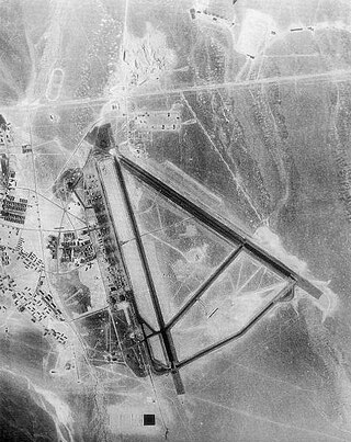
Tonopah Test Range Airport, at the Tonopah Test Range is 27 NM southeast of Tonopah, Nevada, and 140 mi (230 km) northwest of Las Vegas, Nevada. It is a major airfield with a 12,000 ft × 150 ft runway, instrument approach facilities, and nighttime illumination. The facility has over fifty hangars and an extensive support infrastructure.

The 1st Combat Evaluation Group was a Strategic Air Command (SAC) unit. It was formed on 1 August 1961 to merge the 3908th Strategic Standardization Group for SAC aircrew evaluation with the 1st Radar Bomb Scoring Group that had originated from the 263rd Army Air Force Base Unit which transferred from 15th AF to directly under Strategic Air Command c. 1946. The 1CEVG formed after SAC switched to low-level tactics to counter Soviet surface-to-air missiles and SAC had "developed a Radar Bomb Scoring field kit for use in NIKE Systems" in early 1960 for scoring SAC training missions against US Hercules SAM sites. The 1CEVG headquarters included an Office of History and a "standardization and evaluation school" for command examiners.

The Nevada Test and Training Range (NTTR) is one of two military training areas at the Nellis Air Force Base Complex in Nevada and used by the United States Air Force Warfare Center at Nellis Air Force Base. The NTTR land area includes a "simulated Integrated Air Defense System", several individual ranges with 1200 targets, and 4 remote communication sites. The current NTTR area and the range's former areas have been used for aerial gunnery and bombing, for nuclear tests, as a proving ground and flight test area, for aircraft control and warning, and for Blue Flag, Green Flag, and Red Flag exercises.

Babbitt was a populated place established in Mineral County, Nevada, as a 1941 government housing facility for workers of the neighboring Hawthorne Naval Ammunition Depot. Subsequently used as a Cold War radar station, remaining town structures include the school building at the intersection of 21st Street and Yorktown Avenue and numerous concrete building foundations. An RV park is located at the east side of the former community.
Tonopah Air Force Base is a Formerly Used Defense Site (FUDS) in the USA that was a Tonopah Basin military installation until shortly after it was designated an Air Force Base in 1948. Two of the runways still in use are maintained by Nye County, Nevada; and World War II building foundations and three hangars of the base remain at the municipal Tonopah Airport.

The Reeves AN/MSQ-77 Bomb Directing Central, Radar was a United States Air Force automatic tracking radar/computer system for command guidance of aircraft. It was often used during Vietnam War bomb runs at nighttime and during bad weather. Developed from the Reeves AN/MSQ-35, the AN/MSQ-77 reversed the process of Radar Bomb Scoring by continually estimating the bomb impact point before bomb release with a vacuum tube ballistic computer. Unlike "Course Directing Centrals" which guided aircraft to a predetermined release point, the AN/MSQ-77 algorithm continuously predicted bomb impact points during the radar track while the AN/MSQ-77's control commands adjusted the aircraft course. A close air support regulation prohibited AN/MSQ-77 Combat Skyspot bombing within 1,000 yd (910 m) of friendly forces unless authorized by a Forward Air Controller, and "on several occasions" strikes were as close as 273 yd (250 m).
Radar Bomb Scoring is a combat aviation ground support operation used to evaluate Cold War aircrews' effectiveness with simulated unguided bomb drops near radar stations of the United States Navy, the USAF Strategic Air Command, and Army Project Nike units. USAF RBS used various ground radar, computers, and other electronic equipment such as jammers to disrupt operations of the bomber's radar navigator, AAA/SAM simulators to require countermeasures from the bomber, and Radar Bomb Scoring Centrals for estimating accuracy of simulated bombings. Scores for accuracy and electronic warfare effectiveness were transmitted from radar sites such as those at Strategic Range Training Complexes.
RBS Express railroad trains were 3 mobile United States Air Force radar stations for 1CEVG Radar Bomb Scoring (RBS) of Strategic Air Command bomber crews beginning in March 1961. Electronic equipment included the "MSQ-39, TLQ-11, MPS-9, and the IFF/SIF for the MSQ-39" along with support railcars, and the trains were temporarily used at various rail sites with the radar antennas emplaced using hoists built onto flatcars. Pulled by a "contracted locomotive" that left the train at the site, and a North American B-25 Mitchell was used for calibration of the radar station.

The 99th Range Group is an inactive United States Air Force (USAF) unit. It was last stationed at Nellis AFB, Nevada, where it was responsible for the Nevada Test and Training Range (NTTR).
Test and Training Range may refer to:

The Nellis Air Force Base Complex is the southern Nevada military region of federal facilities and lands, e.g., currently and formerly used for military and associated testing and training such as Atomic Energy Commission atmospheric nuclear detonations of the Cold War. The largest land area of the complex is the Nevada Test and Training Range, and numerous Formerly Used Defense Sites remain federal lands of the complex. Most of the facilities are controlled by the United States Air Force and/or the Bureau of Land Management, and many of the controlling units are based at Creech and Nellis Air Force Bases. Initiated by a 1939 military reconnaissance for a bombing range, federal acquisition began in 1940, and McCarran Field became the World War II training area's 1st of 3 Nevada World War II Army Airfields and 10 auxiliary fields. The area's first military unit was initially headquartered in the Las Vegas Federal Building while the WWII Las Vegas Army Airfield buildings were constructed.
The Salt Lake City Radar Bomb Scoring Site is a Formerly Used Defense Site that was an automatic tracking (AUTOTRACK) radar station during the Cold War. Operated by Detachment 6 of the 11th Radar Bomb Scoring Squadron which had relocated from the Phoenix semi-mobile RBS station in December 1964, the military installation evaluated practice bomb runs by Strategic Air Command simulating attacks on the metropolitan area and on the Hill Air Force Range which had been the Salt Lake City Army Air Base Gunnery Range in World War II.
Havre Electronic Bomb Scoring Site is a Formerly Used Defense Site for USAF evaluation of aircrews on training missions. The site was initially established for the 1965 Fairchild Trophy, the Strategic Air Command Bombing and Navigation Competition. ; the RBS Express was stationed at a siding near Chinook, Montana; and a new "temporary mobile radar site" 35 mi (56 km) northeast of Havre, Montana, was announced in 1982. The 1983 site was in Hill County, Montana, with seven semi-trailers, and a new permanent site was approved by 1984 for also north of Havre "Upon decommissioning of [the mobile site at] Havre, MT Serial Number 7 went to Detachment 18, Forsyth, Montana for SAC Bomb-Comp 1987 and then to Detachment 20, 1 CEVG in early 1988."
