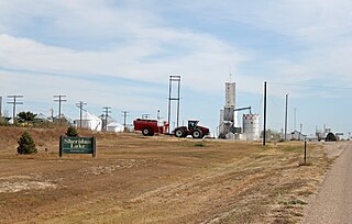
The Town of Sheridan Lake is a Statutory Town located in Kiowa County, Colorado, United States. The population was 88 at the 2010 census, up from 66 at the 2000 census.

The Laramie Mountains are a range of moderately high peaks on the eastern edge of the Rocky Mountains in the U.S states of Wyoming and Colorado. The range is the northernmost extension of the line of the ranges along the eastern side of the Rockies, and in particular of the higher peaks of the Front Range directly to the south. North of the range, the gap between the Laramie range and the Bighorn Mountains provided the route for historical trails, such as the Oregon Trail, the Mormon Trail, and the Pony Express.

Middle Park is a high basin in the Rocky Mountains of north-central Colorado in the United States. It is located in Grand County, on the southwest slope of Rocky Mountain National Park, approximately 50 miles (80 km) west of Boulder.

Divide is a census-designated place and a U.S. Post Office in Teller County, Colorado, United States. The population as of the 2010 Census was 127. Divide sits on the north slope of Pikes Peak on U.S. Highway 24. Ute Pass is immediately west of town. The Divide Post Office has the ZIP Code 80814.

Florissant is a census-designated place and a U.S. Post Office in Teller County, Colorado, United States. The population as of the 2010 Census was 104. Florissant, Colorado, was named after Florissant, Missouri, the hometown of Judge James Castello, an early settler. The word florissant is the gerund of the French verb fleurir, which roughly means to flourish, to flower, or to blossom.
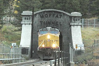
The Moffat Tunnel is a railroad and water tunnel that cuts through the Continental Divide in north-central Colorado. Named after Colorado railroad pioneer David Moffat, the tunnel's first railroad traffic passed through in February 1928.

Mosca is an unincorporated community and a U.S. Post Office in Alamosa County, Colorado, United States. It was named for the nearby Mosca Pass, which was named for the Spanish explorer, Luis de Moscoso Alvarado. The Mosca Post Office has the ZIP Code 81146.

Coaldale is a census-designated place and U.S. post office in Fremont County, Colorado, United States. The population as of the 2010 census was 255. The Coaldale Post Office has the ZIP Code 81222.

Howard is a census-designated place and a U.S. post office in Fremont County, Colorado, United States. The population as of the 2010 census was 723. The Howard Post Office has the ZIP code 81233.
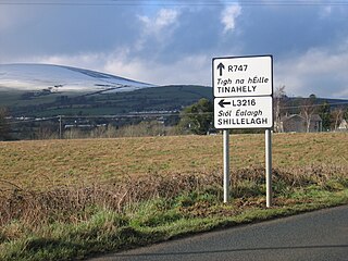
The R747 road is a regional road in Ireland running north-west/south-east from the M9 near Ballitore in County Kildare to Arklow in County Wicklow, a distance of 66 km (41 mi).

Buckskin Joe, also called Laurette or Lauret, is a deserted ghost town in Colorado, United States. It was an early mining town, and county seat of Park County, Colorado.

Jones Place is an unincorporated community in El Dorado County, California. It lies at an elevation of 4921 feet.
Golfland Entertainment Centers are a chain of family amusement centers, miniature golf courses, and water parks located in California and Arizona. The company was founded in 1953.
Ferry Farm is an unincorporated community in Stafford County, in the U.S. state of Virginia.
Centennial Correctional Facility (CCF) is located in the East Canon complex in Fremont County, just east of Canon City, Colorado. CCF consists of two separate buildings, North and South. The South facility, opened in 2011, is a Level V maximum security facility. All offenders in CCF South are in Administrative Segregation (AdSeg), also known as solitary confinement. CCF South is the counterpart of the Colorado State Penitentiary (CSP), also in the East Canon complex. The North facility is the original facility, and primarily houses Level IV maximum security offenders.

Hardscrabble Pass is a mountain pass in South-Central Colorado (USA). It lies between the Wet Mountain Valley to the west and the valley of the Arkansas River to the east. The pass traverses the Wet Mountains. State Highway 96 runs over the pass, linking the towns of Wetmore to the east and Westcliffe to the west.

Groveland is an unincorporated community in McPherson County, Kansas, United States.
Lead Mountain is a summit in Custer County, Colorado, in the United States. It is in the Wet Mountain Range. With an elevation of 9,731 feet (2,966 m), Lead Mountain is the 2343rd highest summit in the state of Colorado.
Coffeepot Pass, elevation 12,726 ft (3,879 m), is a mountain gap and footpath located in the Maroon Bells–Snowmass Wilderness of Colorado. The pass offers a traverse over the Elk Mountains and connects the two counties of Gunnison and Pitkin.


