Hayes Range

Last updated
Hayes Range
Denali Highway and Mt Hayes.JPG
Highest point
Peak Mount Hayes
Elevation 13,832 ft (4,216 m)
Coordinates 63°33′00″N147°53′00″W / 63.55000°N 147.88333°W / 63.55000; -147.88333
Dimensions
Length147 mi (237 km)
Area13,406 sq mi (34,720 km2)
Geography
Relief map of USA Alaska.png
Red triangle with thick white border.svg
Hayes Range
Location in Alaska
CountryUnited States
RegionAlaska

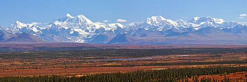
The Hayes Range is a part of the Alaska Range in Denali and the census area of Southeast Fairbanks, Alaska in the United States. The mountains are located to the east of Denali National Park and are located west of the Delta Mountains, from which they are separated by the Delta River. As the crow flies, the Hayes Range is located about 100 miles (160 km) south of Fairbanks, and 200 miles (320 km) northeast of Anchorage. The mountains extend about 147 miles (237 km) from east to west. [1]

The highest point of the range is Mount Hayes, 13,832 feet (4,216 m). [1] Other notable summits of the range include Mount Moffit (2nd-highest), Mount Shand (3rd), Moby Dick (4th), Mount Deborah (5th), Hess Mountain (7th), McGinnis Peak (8th), and Mount Balchen (9th).

Mt. Hayes and the eastern Alaska Range mountains.jpg
Hayes Range from the Denali Highway. Mt. Balchen, Mt. Hayes, Moby Dick, and Shand
The Hayes Range in the area of Monahan Flat and Nenana Mountain Monahan Flat and the eastern Alaska Range mountains.jpg
The Hayes Range in the area of Monahan Flat and Nenana Mountain

Related Research Articles

<span class="mw-page-title-main">Denali</span> Highest mountain in North America

Denali is the highest mountain peak in North America, with a summit elevation of 20,310 feet (6,190 m) above sea level. It is the tallest mountain in the world from base-to-peak on land, measuring 18,000 ft (5,500 m), and Earth's highest mountain north of 43°N. With a topographic prominence of 20,194 feet (6,155 m) and a topographic isolation of 4,621.1 miles (7,436.9 km), Denali is the third most prominent and third-most isolated peak on Earth, after Mount Everest and Aconcagua. Located in the Alaska Range in the interior of the U.S. state of Alaska, Denali is the centerpiece of Denali National Park and Preserve.

<span class="mw-page-title-main">Alaska Range</span> North American mountain range

The Alaska Range is a relatively narrow, 600-mile-long (950 km) mountain range in the southcentral region of the U.S. state of Alaska, from Lake Clark at its southwest end to the White River in Canada's Yukon Territory in the southeast. Denali, the highest mountain in North America, is in the Alaska Range. The range is part of the American Cordillera.

<span class="mw-page-title-main">Denali National Park and Preserve</span> National park in Alaska, US

Denali National Park and Preserve, formerly known as Mount McKinley National Park, is an American national park and preserve located in Interior Alaska, centered on Denali, the highest mountain in North America. The park and contiguous preserve encompass 6,045,153 acres which is larger than the state of New Hampshire. On December 2, 1980, 2,146,580-acre Denali Wilderness was established within the park. Denali's landscape is a mix of forest at the lowest elevations, including deciduous taiga, with tundra at middle elevations, and glaciers, snow, and bare rock at the highest elevations. The longest glacier is the Kahiltna Glacier. Wintertime activities include dog sledding, cross-country skiing, and snowmobiling. The park received 594,660 recreational visitors in 2018.

<span class="mw-page-title-main">Kuskokwim River</span> River in Alaska, United States

The Kuskokwim River or Kusko River is a river, 702 miles (1,130 km) long, in Southwest Alaska in the United States. It is the ninth largest river in the United States by average discharge volume at its mouth and seventeenth largest by basin drainage area. The Kuskokwim River is the longest river system contained entirely within a single U.S. state.

<span class="mw-page-title-main">Nenana River</span> River in Alaska, United States

The Nenana River is a tributary of the Tanana River, approximately 140 miles (230 km) long, in central Alaska in the United States. It drains an area on the north slope of the Alaska Range on the south edge of the Tanana Valley southwest of Fairbanks.

<span class="mw-page-title-main">Denali Highway</span> Highway in Alaska, USA

Denali Highway is a lightly traveled, mostly gravel highway in the U.S. state of Alaska. It leads from Paxson on the Richardson Highway to Cantwell on the Parks Highway. Opened in 1957, it was the first road access to Denali National Park. Since 1971, primary park access has been via the Parks Highway, which incorporated a section of the Denali Highway from Cantwell to the present-day park entrance. The Denali Highway is 135 miles (217 km) in length.

<span class="mw-page-title-main">Mount Hayes</span> Mountain in Alaska, United States

Mount Hayes is the highest mountain in the eastern Alaska Range, in the U.S. state of Alaska. Despite not being a fourteener, it is one of the largest peaks in the United States in terms of rise above local terrain. For example, the Northeast Face rises 8,000 feet (2,440 m) in approximately 2 miles (3.2 km). This large vertical relief contributes to Mount Hayes being the 51st most topographically prominent peak in the world.

<span class="mw-page-title-main">Tordrillo Mountains</span> Mountain range in Alaska, U.S.

The Tordrillo Mountains are a small mountain range in the Matanuska-Susitna and Kenai Peninsula Boroughs in the southcentral region of the U.S. state of Alaska. They lie approximately 75 miles (121 km) west-northwest of Anchorage. The range extends approximately 60 miles (97 km) north-south and 35 miles (56 km) east-west. The highest point is Mount Torbert. On a clear day, they are easily visible from Anchorage.

<span class="mw-page-title-main">Harry Karstens</span>

Henry Peter Karstens was the first superintendent of Denali National Park, from 1921 to 1928. He was the guide and climbing leader of the first complete ascent of Denali in 1913, with expedition members Hudson Stuck, Walter Harper and Robert Tatum. John Fredson and Esaias George were two young Gwich'in Alaska Natives who supported the party.

<span class="mw-page-title-main">Delta Mountains</span>

The Delta Mountains or Delta Range are a subrange of the Alaska Range, forming its eastern terminus. The mountains extend about 95 miles (153 km) from east to west, to the south of the Tanana River Valley, west of the Nebesna River and northwest of Wrangell-St. Elias National Park and the Copper River, and cover an area of 6,313 square miles (16,350 km2). The highest point of the range is Mount Kimball, at 10,300 feet (3,100 m).

<span class="mw-page-title-main">Mount Deception (Alaska)</span>

Mount Deception is a 11,539-foot (3,517 m) mountain in the Alaska Range, in Denali National Park and Preserve. Mount Deception lies 16 miles (26 km) east-southeast of Denali, overlooking Brooks Glacier. The glacier-covered mountain was named by a U.S. Army crash investigation party on November 13, 1944, who were the first to ascend the mountain while investigating an airplane crash that happened in September 1944.

<span class="mw-page-title-main">Mount Frances</span>

Mount Frances is a 10,450 ft (3,190 m) mountain summit located in the Kahiltna Glacier valley in the Alaska Range, in Denali National Park and Preserve, in the U.S. state of Alaska. It is situated north of the Kahiltna Glacier base camp for mountaineers attempting to climb Denali, Mount Foraker, or Mount Hunter. The summit of Mt. Frances is the best viewpoint from which to see all three giants from one location. Mount Frances is set 7.43 mi (12 km) southwest of Denali, 3.47 mi (6 km) northwest of Mount Hunter, and 1.3 mi (2 km) northwest of Radio Control Tower. Access to the area is via air taxi from Talkeetna. The mountain's name honors Frances Randall (1925-1984), the first Denali Base Camp manager for nine climbing seasons (1974-1983). She was planning a tenth season, but cancer claimed her life. Her expertise was instrumental in coordinating many rescues that saved lives and earned her the nicknames Guardian Angel of McKinley, and Kahiltna Queen. She was a member of the Fairbanks Symphony Orchestra, often playing the violin at base camp over the CB radio. In 1964 she became the sixth woman to reach the summit of Mount McKinley.

<span class="mw-page-title-main">McGinnis Peak (Alaska Range)</span>

McGinnis Peak is an 11,400 ft (3,470 m) elevation glaciated summit located at the head of McGinnis Glacier in the eastern Alaska Range, in Alaska, United States. It is the eighth-highest peak in the Hayes Range, a subset of the Alaska Range. This remote peak is situated 14 mi (23 km) southeast of Mount Hayes, and 95 mi (153 km) southeast of Fairbanks. Mount Moffit, the nearest higher neighbor, is set 3.33 mi (5 km) to the northwest, and Mount Shand is positioned 4.5 mi (7 km) to the west. The Richardson Highway is 15 mi (24 km) to the east, with Hayes, McGinnis, and Moffit dominating the landscape along the drive south.

<span class="mw-page-title-main">Mount Shand</span>

Mount Shand is a 12,660 ft (3,860 m) elevation glaciated summit located at the head of the Trident Glacier in the eastern Alaska Range, in Alaska, United States. It is the third-highest peak in the Hayes Range, a subset of the Alaska Range. This remote peak is situated 9.8 mi (16 km) east-southeast of Mount Hayes, and 93 mi (150 km) southeast of Fairbanks. Mount Moffit, the nearest higher neighbor, is set 2.3 mi (4 km) to the northeast, and McGinnis Peak is positioned 4.5 mi (7 km) to the east. This rarely climbed mountain has three large sweeping faces, the East, West, and South.

<span class="mw-page-title-main">Hess Mountain</span>

Hess Mountain, also known as Mount Hess, is an 11,940 ft (3,640 m) elevation glaciated summit located on the crest of the Alaska Range, in Alaska, United States. It is the seventh-highest peak in the Hayes Range which is a subrange of the Alaska Range. This remote peak is situated 13.3 mi (21 km) west of Mount Hayes, and 90 mi (145 km) south of Fairbanks. Mount Deborah, the nearest higher neighbor, is positioned 2.8 mi (5 km) to the west. Precipitation runoff from the mountain drains into tributaries of the Susitna and Tanana River drainage basins. The mountain's name was reported in 1912 by the United States Geological Survey. The first ascent was made May 24, 1951, by Alston Paige, Dick Holdren, Ed Huizer, Howard Bowman, and Elton Thayer. The first ascent via the North Ridge was made May 23, 1976, by Steven Hackett and Thomas Hillis.

<span class="mw-page-title-main">Moby Dick (Alaska)</span>

Moby Dick is a 12,360 ft (3,770 m) elevation glaciated summit located at the head of the Trident Glacier in the eastern Alaska Range, in Alaska, United States. It is the fourth-highest peak in the Hayes Range, a subset of the Alaska Range. This remote peak is situated 5.7 mi (9 km) southeast of Mount Hayes, and 92 mi (148 km) southeast of Fairbanks. Mount Shand, the nearest higher neighbor, is set 4.7 mi (8 km) to the east. The first ascent of this unofficially named mountain was made in 1964 by Christopher Goetze, Lydia Goetze, Tom Knott, and Larry Muir.

<span class="mw-page-title-main">Kahiltna Queen</span>

Kahiltna Queen is a 12,380-foot-elevation (3,773-meter) mountain summit in the U.S. state of Alaska.

<span class="mw-page-title-main">Mount Balchen (Alaska)</span>

Mount Balchen is an 11,205-foot-elevation (3,415-meter) mountain summit in Alaska, United States.

References

  1. 1 2 "Hayes Range". Peakbagger. 2004. Retrieved 2016-12-26.