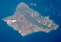
Oʻahu anglicized Oahu, known as "The Gathering Place", is the third-largest of the Hawaiian Islands. It is home to roughly one million people—about two-thirds of the population of the U.S. state of Hawaii. The state capital, Honolulu, is on Oʻahu's southeast coast. Including small associated islands such as Ford Island and the islands in Kāneʻohe Bay and off the eastern (windward) coast, its area is 596.7 square miles (1,545.4 km2), making it the 20th-largest island in the United States.

Ahuimanu or ʻĀhuimanu is a census-designated place (CDP) in the City & County of Honolulu, Hawaii, United States, on the island of Oahu. In Hawaiian ʻāhui-manu means "cluster of birds".

Heʻeia is a census-designated place comprising several neighborhoods located in the City & County of Honolulu and the Koʻolaupoko District on the island of Oʻahu north of Kāneʻohe. In Hawaiian the words heʻe ʻia mean "washed away", alluding to a victory achieved by the populace against others from leeward Oʻahu, aided by a tsunami that washed the combatants off the shore.
Kāneʻohe is a census-designated place (CDP) included in the City and County of Honolulu and located in Hawaiʻi state District of Koʻolaupoko on the island of Oʻahu. In the Hawaiian language, kāne ʻohe means "bamboo man". According to an ancient Hawaiian story a local woman compared her husband's cruelty to the sharp edge of cutting bamboo; thus the place was named Kāneʻohe or "Bamboo man". The population was 34,597 at the 2010 census. Kāneʻohe is the largest of several communities along Kāneʻohe Bay and one of the two largest residential communities on the windward side of Oʻahu. The commercial center of the town is spread mostly along Kamehameha Highway.
Marine Corps Base Hawaii (MCBH), formerly Marine Corps Air Station Kaneohe Bay and originally Naval Air Station Kaneohe Bay, is a U.S. Marine Corps facility and air station located on the Mokapu Peninsula of windward O'ahu in the City & County of Honolulu. For census purposes, the area is demarcated as the Kaneohe Station census-designated place, with a population at the 2010 Census of 9,517. Marine Corps Base Hawaii is home to Marines, sailors, their family members and civilian employees. The United States Marine Corps operates a 7,800-foot (2,400 m) runway at the base.
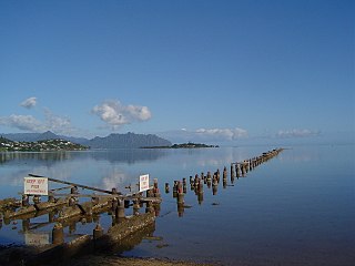
Kāneʻohe Bay, at 45 km², is the largest sheltered body of water in the main Hawaiian Islands. This reef-dominated embayment constitutes a significant scenic and recreational feature along the northeast coast of the Island of Oʻahu. The largest population center on Kāneʻohe Bay is the town of Kāneʻohe.

North Koʻolaupoko is an area in the County of Honolulu, Hawaii, United States, on the island of Oʻahu. It corresponds to the Waikane census-designated place, with a population of 778 at the 2010 census. In Hawaiian, koʻolau poko means "short windward", referring to the fact that this is the shorter of the two windward districts on the island. Koʻolaupoko extends from Makapuʻu Point on the southeast to Kaʻōʻio Point on the north. Included within the district, south of North Koʻolaupoko, are the largest windward towns of Kāneʻohe, Kailua, and Waimānalo.

Nuʻuanu Pali is a section of the windward cliff of the Koʻolau mountain located at the head of Nuʻuanu Valley on the island of Oʻahu. It has a panoramic view of the windward (northeast) coast of Oʻahu. The Pali Highway connecting Kailua/Kāneʻohe with downtown Honolulu runs through the Nuʻuanu Pali Tunnels bored into the cliffside.
Kamehameha Highway is one of the main highways serving suburban and rural O‘ahu in the U.S. state of Hawaii. Starting from Nimitz Highway near Pearl Harbor and Hickam Air Force Base in Honolulu, it serves the island's older western suburbs, turning north across the O‘ahu Central Valley to the North Shore. At the North Shore, Kamehameha Highway heads northeast around the northern tip of O‘ahu, then southeast to and just beyond Kāne‘ohe Bay on the windward coast. The road was named after King Kamehameha I.

Kualoa is a 4000-acre private nature reserve and working cattle ranch, as well as a popular tourist attraction and filming location on the windward coast of Oʻahu in Hawaiʻi. It is located about 24 miles from Honolulu, and 32 miles from Haleiwa. The ranch consists of 3 valleys: Kaʻaʻawa Valley, Kualoa Valley, and Hakipuʻu Valley. The ranch is located on Hawaii State Route 83 between Kaʻaʻawa and Waikane. The main street address is 49-560 Kamehameha Highway, Kāneʻohe, Hawaiʻi 96744.

Mokolii, commonly known as Chinaman's Hat, is a basalt islet in Kāneʻohe Bay, Hawaii. Mokoliʻi is part of Kualoa Regional Park and located 1⁄3 mile (0.54 km) offshore of Kualoa Point, Oahu. The 12.5-acre (5.1 ha) islet was at one time part of a basaltic ridge on Oahu before marine erosion separated it.

Marine Corps Air Station Kaneohe Bay or MCAS Kaneohe Bay is a United States Marine Corps airfield located within the Marine Corps Base Hawaii complex, formerly known as Marine Corps Air Facility (MCAF) Kaneohe Bay or Naval Air Station (NAS) Kaneohe Bay. It is located two miles northeast of the central business district of Kaneohe, in Honolulu County, Hawaii, United States. The airfield has one runway (4/22) with a 7,771 x 200 ft asphalt surface.

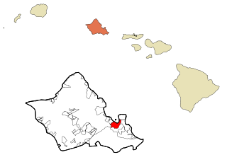
Honolulu County is a consolidated city–county in the U.S. state of Hawaii. The city–county includes both the city of Honolulu and the rest of the island of Oʻahu, as well as several minor outlying islands, including all of the Northwestern Hawaiian Islands except Midway Atoll.
The transportation system of Hawaii is a cooperation of complex systems of infrastructure.

This is a list of properties and districts on the Hawaiian island of Oahu that are listed on the National Register of Historic Places. Oahu is the only major island in Honolulu County. The location of the city of Honolulu, Oahu is the most populous island in the state. There are 166 properties and districts on the island, including 16 National Historic Landmarks. Three formerly listed sites were demolished and have been removed from the Register.

Ulupō Heiau on the eastern edge of Kawai Nui Marsh in Kailua, Hawaiʻi, is an ancient site associated in legend with the menehune, but later with high chiefs of Oʻahu, such as Kakuhihewa in the 15th century and Kualiʻi in the late 17th century. It may have reached the peak of its importance in 1750, before being abandoned after Oʻahu was conquered in the 1780s. The site became a territorial park in 1954, was partially restored in the early 1960s, marked with a bronze plaque by the State Commission on Historical Sites in 1962, and listed on the National Register of Historic Places in 1972.
The Sullivan Family of Companies is a privately run American supermarket, retailer and restaurant franchiser headquartered in Honolulu, Hawaii. The family-owned business is run by Jenai S. Wall, the daughter of Maurice J. "Sully" Sullivan, who founded the Foodland supermarket chain, which she expanded after his death. Although all of the properties are under the same roof, each is run separately.

Kualoa Regional Park is located at Kāneʻohe Bay, on the island of Oahu in the U.S. state of Hawaii. The park covers 153 acres across the road from the Pali-ku (cliffs) of the Koʻolau Range. The beach front is white sand and 1/3 mile offshore is the small basalt island of Mokoliʻi.

Moliʻi Fishpond is located southeast of Kamehameha Highway between Kualoa and Johnson Roads, near Kaneohe, on the island of Oahu, in the U.S. state of Hawaii. The pond encompasses 125 acres The locale is part of the ahupuaa of Hakipuu. The Molii pond is part of Kualoa Ranch. Tilapia, mullet and moi are found within the pond. Commercial fishing operations are contracted out.

Energy in Hawaii is complicated by the state's isolated location and lack of fossil fuel resources. The state relies heavily on imports of petroleum and coal for power although renewable energy is increasing. Hawaii is the state with the highest share of petroleum use in the United States, with about 62% of electricity coming from oil in 2017. As of 2016, 26.6% of electricity was from renewable sources, including solar, wind, hydro and geothermal.


